|
|
| Akiachak Airport |
 |
| IATA: none – ICAO: none – FAA LID: Z13 |
| Summary |
| Airport type |
Public |
| Owner |
State of Alaska DOT&PF |
| Serves |
Akiachak, Alaska |
| Elevation AMSL |
25 ft / 8 m |
| Coordinates |
60°54′17″N 161°25′21″W / 60.90472°N 161.4225°W / 60.90472; -161.4225 |
| Runways |
| Direction |
Length |
Surface |
| ft |
m |
| 11/29 |
1,649 |
503 |
Gravel |
| Statistics |
| Enplanements (2007) |
2,607 |
| Operations (2005) |
3,000 |
| Source: FAA |
Akiachak Airport (FAA LID: Z13) is a state-owned public-use airport located in Akiachak, in the Bethel Census Area of the U.S. state of Alaska.
As per Federal Aviation Administration records, this airport had 2,607 passenger boardings (enplanements) in calendar year 2007, an increase of 44% from the 1,811 enplanements in 2006. Facilities
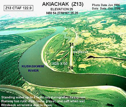
Akiachak Airport has one runway designated 11/29 with a 1,649 by 40 ft (503 x 12 m) gravel surface. For the 12-month period ending August 26, 2005, the airport had 3,000 aircraft operations, an average of 250 per month, all of which were air taxi.
The state has plans to acquire 236 acres (0.96 km) to relocate the airport and build a new 3,300-foot (1,000 m) runway.
Airlines
- Hageland Aviation Services
The above content comes from Wikipedia and is published under free licenses – click here to read more.
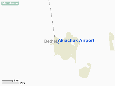
Location
& QuickFacts
| FAA Information Effective: |
2005-10-27 |
| Airport Identifier: |
Z13 |
| Longitude/Latitude: |
161-25-20.8000W/60-54-17.4000N
-161.422444/60.904833 (Estimated) |
| Elevation: |
25
ft / 7.62 m (Estimated) |
| Land: |
0
acres |
| From nearest city: |
0
nautical miles SE of Akiachak, AK |
| Location: |
Bethel
County, AK |
| Magnetic Variation: |
19E
(1985) |
Owner
& Manager
| Ownership: |
Publicly
owned |
| Owner: |
State
Of Alaska Dot |
| Address: |
2016
Airport Road
Anchorage, AK 99519-6900 |
| Phone number: |
907-269-0747 |
| Manager: |
Bethel
Arpt Mgr |
| Address: |
2016
Airport Road
Bethel, AK 99559 |
| Phone number: |
907-543-2495 |
Airport
Operations and Facilities
| Airport Use: |
Open
to public |
| Wind indicator: |
Yes
WINDSOCK ALSO FOR SPB. |
| Segmented Circle: |
No |
| Control Tower: |
No |
| Attendance Schedule: |
UNATNDD |
| Landing fee charge: |
No |
| Sectional chart: |
Mc
Grath |
| Region: |
AAL
- Alaska |
| Boundary ARTCC: |
ZAN
- Anchorage |
| Tie-in FSS: |
ENA
- Kenai |
| FSS on Airport: |
No |
| FSS Phone: |
800-478-3576 |
| FSS Toll Free: |
1-800-WX-BRIEF |
| NOTAMs Facility: |
BET
(NOTAM-d service avaliable) |
| Federal Agreements: |
N |
Airport
Communications
Airport
Services
| Airframe Repair: |
NONE |
| Power Plant Repair: |
NONE |
| Bottled Oxygen: |
NONE |
| Bulk Oxygen: |
NONE |
Runway
Information
Runway
11/29
| Dimension: |
1649
x 40 ft / 502.6 x 12.2 m |
| Surface: |
GRVL,
Fair Condition
HAS RUTS & DIPS - LOOSE GRVL ON SFC - SOFT WHEN WET. |
| |
Runway
11 |
Runway
29 |
| Longitude: |
161-25-35.5370W |
161-25-05.9937W |
| Latitude: |
60-54-21.0814N |
60-54-13.7393N |
| Elevation: |
22.00
ft |
23.00
ft |
| Alignment: |
117 |
127 |
| Traffic Pattern: |
Left |
Left |
| Obstruction: |
25
ft road, 250.0 ft from runway, 25 ft right of centerline,
10:1 slope to clear |
13
ft bushes, 220.0 ft from runway, 80 ft right of centerline,
16:1 slope to clear |
|
Radio
Navigation Aids
| ID |
Type |
Name |
Ch |
Freq |
Var |
Dist |
| ET |
NDB |
Bethel |
|
344.00 |
19E |
13.4
nm |
| OSE |
NDB |
Oscarville |
|
251.00 |
19E |
14.8
nm |
| BET |
VORTAC |
Bethel |
088X |
114.10 |
19E |
13.8
nm |
Remarks
- CAUTION:
RWY CONDITION NOT MONITORED; RECOMMEND VISUAL INSPECTION PRIOR TO
USING.
- STANDING
WATER 2 TO 4 INCHES ON RY DURING & AFTER HEAVY RAIN.
- THR
PANELS DAMAGED - MAY NOT BE CLEARLY VISIBLE.
Location: Bethel
County, AK
Tel: 907-543-2495
Images and information placed above are from
http://www.airport-data.com/airport/Z13/
We thank them for the data!
|
|