|
|
| Adak Airport |
| IATA: ADK – ICAO: PADK – FAA LID: ADK
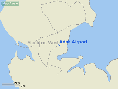
Location of airport in Alaska
|
| Summary |
| Airport type |
Public |
| Owner |
Alaska DOT&PF - Central Region |
| Serves |
Adak Island, Alaska |
| Location |
Adak |
| Elevation AMSL |
18 ft / 5 m |
| Coordinates |
51°52′41″N 176°38′46″W / 51.87806°N 176.64611°W / 51.87806; -176.64611 |
| Runways |
| Direction |
Length |
Surface |
| ft |
m |
| 5/23 |
7,790 |
2,374 |
Asphalt |
| 18/36 |
7,605 |
2,318 |
Asphalt |
| Statistics (2009) |
| Aircraft operations |
155 |
| Enplanements (2008) |
1,989 |
| Sources: Federal Aviation Administration |
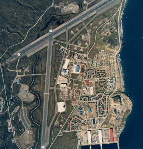
Adak Airport (IATA: ADK, ICAO: PADK, FAA LID: ADK), formerly Naval Air Station Adak, is a state-owned, public-use airport located west of Adak, on Adak Island in the U.S. state of Alaska. The airport is the farthest west for the entire United States at 176.64W.
As per Federal Aviation Administration records, the airport had 1,989 passenger boardings (enplanements) in calendar year 2008, a decrease of 5.38% from the 2,102 enplanements in 2007. This airport is included in the FAA's National Plan of Integrated Airport Systems for 2009–2013, which categorizes it as a general aviation facility.
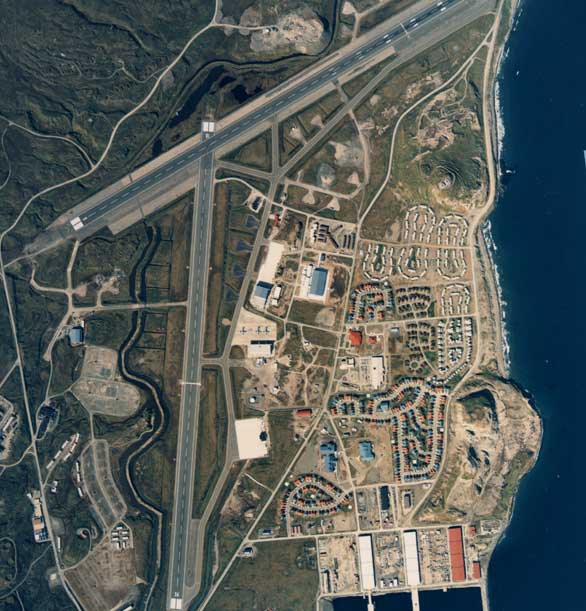
Adak's airport is one of the largest and most sophisticated airports in the Aleutian Islands. Built by the U.S. Navy for Naval air transport, the airport is a world-class facility consisting of a 7,800-foot (2,400 m) runway and a 7,600-foot (2,300 m) runway, equipped with an Instrument Landing System and glideslope which facilitate Instrument Flight Rules landings. Adak currently has scheduled jet service provided by Alaska Airlines. History
The military first developed an air station on Adak during World War II. Adak Army Airfield was used during the Aleutian Campaign by both USAAF and Naval Air units. Known units assigned were:
- 343d Fighter Group (March 7, 1943 – July 25, 1943)
- 28th Bombardment Group (March 14, 1943 – February 26, 1944)
- 42d Fighter Squadron (September 10 – December 12, 1942) (54th FG)
Adak was most recently run by the U.S. Navy as a deployment base for P-3 Orion maritime patrol aircraft, primarily to conduct antisubmarine warfare operations against submarines and surveillance of naval surface vessels of the former Soviet Union.
With the fall of the Soviet Union in the early 1990s, NAS Adak's operational viability as a front-line military installation began to wane, and in the mid-1990s a decision was made by the federal government to cease military flight operations there under the military's Base Realignment and Closure Program (BRAC). That decision made the land at NAS Adak eligible for transfer back to The Aleut Corporation. The military will remain on Adak, however, as part of its environmental monitoring and cleanup program.
Facilities and aircraft
Adak Airport has two asphalt paved runways: 5/23 is 7,790 by 200 feet (2,374 x 61 m) and 18/36 is 7,605 by 200 feet (2,318 x 61 m). For the 12-month period ending September 20, 2009, the airport had 155 aircraft operations, an average of 12 per month: 65% scheduled commercial, 32% general aviation, and 3% military.
Airline and destination
Airline service is subsidized by the Essential Air Service program. Alaska Airlines provides 2 flights weekly with Boeing 737 aircraft.
- Alaska Airlines (Anchorage)
The above content comes from Wikipedia and is published under free licenses – click here to read more.
Adak International Airport-in-waiting. Modern Airfield
facilities include: two 7,800 ft. runways, taxiways, aircraft parking
pavement, aircraft maintenance hangars, ground support equipment, control
tower, terminal building, aircraft crash/fire station at a cost to the
U.S. Government of more than 30 million dollars. Sitting strategically
halfway between Russia, Asia and the U. S. West Coast. Adak's modern airport
and facilities are Internationally important.
|
 |
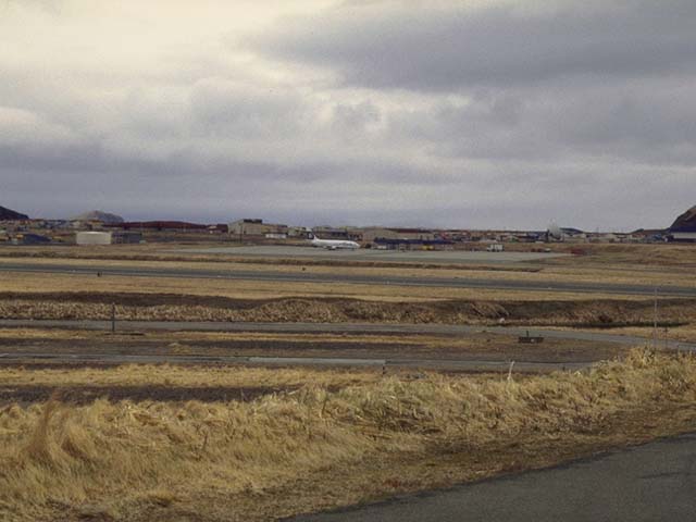
(Click on the photo to
enlarge) |
Reliable and efficient air transportation is important
for community operations on Adak. Adak's airport supports families and
businesses in the region. Adak is blessed with the largest and most sophisticated
airport in the Aleutian Islands…a multi million dollar facility
consisting of two, 78-hundred foot paved runways with advanced IFR electronic
navigation and weather reporting systems.
Additional airport support features include control tower
and terminal buildings, paved taxiways and aircraft parking areas, maintenance
hangers, and a fully equipped fire and crash station.
|
 |
(Click on the photo to
enlarge) |
Adak's unique geographic location and local fishing resources
makes it the perfect location for a logistical base supporting commercial
and charter flights between Alaska and Eastern Asia and the Russian Far
East. In addition to refueling services, the island facilities include
hangers for aircraft maintenance, warehouses for storage of supplies and
equipment, and housing for personnel.
Currently, the US Department of Transportation ensures
that Adak receives proper scheduled air service from Anchorage and Cold
Bay, Alaska. Pen Air currently serves Adak with twice weekly service from
Anchorage, and a new carrier, Evergreen International is scheduled to
re-implement passenger jet and cargo service between Anchorage and Adak
shortly.
Location & QuickFacts
|
FAA
Information Effective: |
2005-10-27 |
|
Airport Identifier: |
ADK |
|
Longitude/Latitude: |
176-38-45.7100W/51-52-40.6700N
-176.646031/51.877964 (Estimated) |
|
Elevation: |
18 ft / 5.49 m (Surveyed) |
|
Land: |
0
acres |
|
From nearest city: |
0 nautical miles
W of Adak Island, AK |
|
Location: |
Aleutian
Islands County, AK |
|
Magnetic Variation: |
09E (1985) |
Owner & Manager
|
Ownership: |
Publicly
owned |
|
Owner: |
State Of Alaska-dotpf-central
Rgn |
|
Address: |
P
O Box 196900
Anchorage, AK 99519 |
|
Phone number: |
907-842-5511 |
|
Manager: |
Norman
Heyano |
|
Address: |
P O Box 250
Dillingham, AK 99576 |
|
Phone number: |
907-592-8026 |
Airport Operations and Facilities
|
Airport
Use: |
Open
to public |
|
Wind indicator: |
Yes |
|
Segmented Circle: |
No |
|
Control Tower: |
No |
|
Attendance Schedule: |
ALL/ALL/0800-1600 |
|
Lighting Schedule: |
RDO-CTL
ACTVT PAPI RY 23 - CTAF. |
|
Beacon Color: |
Clear-Green (lighted
land airport) |
|
Sectional chart: |
W
Aleutian Isls |
|
Region: |
AAL - Alaska |
|
Boundary ARTCC: |
ZAN
- Anchorage |
|
Tie-in FSS: |
CDB - Cold Bay |
|
FSS on Airport: |
No |
|
FSS Phone: |
907-532-2454 |
|
FSS Toll Free: |
1-800-478-7250 |
|
Alternate FSS: |
ENA - Kenai |
|
Alt. FSS Toll Free: |
1-800-WX-BRIEF |
|
NOTAMs Facility: |
PADK (NOTAM-d service
avaliable) |
|
Certification type/date: |
??
11/2000
PPR 12 HRS FOR ALL AIR CARRIER OPERATIONS WITH MORE THAN 30 PASSENGER
SEATS, CONTACT AMGR AT 907-592-8092. |
|
Federal Agreements: |
N |
Airport Communications
Airport Services
|
Fuel
available: |
A1 |
|
Airframe
Repair: |
NONE |
|
Power
Plant Repair: |
NONE |
|
Bottled Oxygen: |
NONE |
|
Bulk Oxygen: |
NONE |
Runway Information
Runway 05/23
|
Dimension: |
7790
x 200 ft / 2374.4 x 61.0 m |
|
Surface: |
ASPH,
Good Condition |
|
Surface Treatment: |
Saw-cut or plastic Grooved |
|
Weight Limit: |
Single wheel: 80000 lbs.
Dual wheel: 145000 lbs.
Dual tandem wheel: 325000 lbs.
Dual dual tandem wheel: 770000 lbs. |
|
|
Runway 05 |
Runway 23 |
|
Longitude: |
176-39-26.9800W |
176-37-38.8600W |
|
Latitude: |
51-52-42.0200N |
51-53-19.7700N |
|
Elevation: |
17.00 ft |
15.00 ft |
|
Alignment: |
61 |
127 |
|
ILS Type: |
|
LOC/GS |
|
Traffic Pattern: |
Right |
Left |
|
Markings: |
Precision instrument, Poor Condition
RUNWAY MARKING IS FADED,NON-STANDARD AND WITHOUT REFLECTIVE
BEADS. |
Precision instrument, Poor Condition
RUNWAY MARKING IS FADED, NON-STANDARD AND WITHOUT REFLECTIVE
BEADS |
|
VASI: |
|
4-light PAPI on right side |
|
Approach lights: |
|
SALSF |
|
Centerline Lights: |
Yes |
No |
|
Touchdown Lights: |
No |
No |
|
Runway 18/36
|
Dimension: |
7605
x 200 ft / 2318.0 x 61.0 m |
|
Surface: |
ASPH,
|
|
Weight Limit: |
Single wheel: 80000 lbs.
Dual wheel: 145000 lbs.
Dual tandem wheel: 325000 lbs.
Dual dual tandem wheel: 770000 lbs. |
|
|
Runway 18 |
Runway 36 |
|
Longitude: |
176-38-52.3000W |
176-39-03.7000W |
|
Latitude: |
51-52-57.7300N |
51-51-43.0600N |
|
Elevation: |
6.00 ft |
4.00 ft |
|
Alignment: |
127 |
5 |
|
Traffic Pattern: |
Left |
Right |
|
Markings: |
Non-precision instrument, |
Non-precision instrument, |
|
Runway End Identifier: |
No |
No |
|
Radio Navigation Aids
|
ID |
Type |
Name |
Ch |
Freq |
Var |
Dist |
|
ADK |
NDB/DME |
Mount Moffett |
087X |
530.00 |
07E |
1.2
nm |
|
NUD |
TACAN |
Adak |
077X |
|
09E |
1.1
nm |
Remarks
-
PSBL WIND SHEARS LNDG/DEPARTING
ALL RYS.
-
GWT RY 18/36: S 80; T
145; TT 325; TDT 770.
-
ALL RWYS GRVD; DO NOT
MAKE LOCKED-BRAKE TURNS.
-
ARFF INDEX A, ARFF EQUIPMENT
STAFFED ONLY DURING AIR CARRIER OPS WITH MORE THAN 30 PASSENGER SEATS.
-
DUTY HOURS: 8AM TO 4PM,
UNATTENDED AFTER DUTY HOURS.
-
ARPT AREA SUBJECT TO
MODERATE TO EXTREME CONCENTRATIONS OF BIRDS.
-
PERSONNEL AND EQUIPMENT
MAY BE WORKING ON THE RWY AT ANY TIME.
-
SNOW AND ICE REMOVAL,
AND ARPT HAZARDOUS REPORTING ONLY PERFORMED DURING DUTY HRS UNLESS BY
PRIOR AGREEMENT IN WRITING WITH ARPT MANAGEMENT.
-
CLOSED TO AIR CARRIER
OPS WITH MORE THAN 30 PASSENGER SEATS EXCEPT PPR IN WRITING TO ARPT.
MANAGER P.O. BOX 250, DILLINGHAM,AK 99576.
-
RECOMMEND VISUAL INSPECTION
OF RUNWAY PRIOR TO USE.
-
PILOTS ARE REQUESTED
TO SELF-ANNOUNCE ON CTAF BEFORE TAXING ON THE RUNWAY FOR DEPARTURE,
LEAVING THE RUNWAY AND 10 NM WHEN APPROACHING TO LAND.
-
EXERCISE EXTREME VIGILANCE
DURG APCH TO ALL RYS; MOUNTAIN TRRN ALL QUADRANTS.
-
GWT RY 05/23: S 80; T
145; TT 325; TDT 770.
-
VOLCANO 5710 FT MSL 22.3
NM BEARING 059 DEGS.
-
JET ACFT STARTING UNITS;
1 - GTC-85 & 1 - NC-10.
Major Carriers Serving This
Airport
Most Popular Destinations
Most Popular Aircraft
|
N741AS |
19.2% |
|
N745AS |
15.4% |
|
N746AS |
15.4% |
|
N740AS |
11.5% |
|
N742AS |
11.5% |
|
000000 |
11.5% |
|
N747AS |
7.7% |
|
N730AS |
7.7% |
Operational Statistics
|
Aircraft
Operations: |
34/Month |
|
Air Carrier: |
25.0% |
|
General Aviation
Itinerant: |
12.5% |
|
Military: |
37.5% |
Adak Airport
Address: Aleutian
Islands County, AZ
Tel:
907-842-5511,
907-592-8026
E-mail: adak@adakisland.com
URL: http://www.alaska.net/~vwadak/airport.html
Images and information placed above are
from
http://www.airport-data.com/airport/ADK/
http://www.alaska.net/~vwadak/airport.html
We thank them for the data!
| General
Info |
| Country |
United
States |
| State |
ALASKA
|
| FAA ID |
ADK |
| Latitude |
51-52-40.670N
|
| Longitude |
176-38-45.710W
|
| Elevation |
18 feet
|
| Near City |
ADAK ISLAND
|
We don't guarantee the information is fresh and accurate. The data may be wrong or outdated.
For more up-to-date information please refer to other sources.
|
|