 |
|
| Weedon Field |
 |
| IATA: EUF – ICAO: KEUF – FAA LID: EUF |
| Summary |
| Airport type |
Public |
| Owner |
City of Eufaula |
| Serves |
Eufaula, Alabama |
| Elevation AMSL |
285 ft / 87 m |
| Coordinates |
31°57′05″N 085°07′44″W / 31.95139°N 85.12889°W / 31.95139; -85.12889 |
| Runways |
| Direction |
Length |
Surface |
| ft |
m |
| 18/36 |
5,000 |
1,524 |
Asphalt |
| Statistics (2008) |
| Aircraft operations |
36,638 |
| Based aircraft |
19 |
| Source: Federal Aviation Administration |
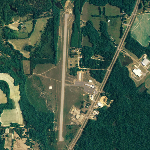
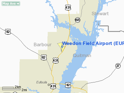
Weedon Field (IATA: EUF, ICAO: KEUF, FAA LID: EUF) is a city-owned public-use airport located three nautical miles (6 km) north of the central business district of Eufaula, a city in Barbour County, Alabama, United States.
Facilities and aircraft
Weedon Field covers an area of 208 acres (84 ha) at an elevation of 285 feet (87 m) above mean sea level. It has one runway designated 18/36 with an asphalt surface measuring 5,000 by 100 feet (1,524 x 30 m).
For the 12-month period ending November 12, 2008, the airport had 36,638 aircraft operations, an average of 100 per day: 74% general aviation and 26% military. At that time there were 19 aircraft based at this airport: 63% single-engine, 5% multi-engine, 5% jet, 5% helicopter and 21% ultralight.
The above content comes from Wikipedia and is published under free licenses – click here to read more.
Location
& QuickFacts
|
FAA Information Effective: |
2007-01-18 |
|
Airport
Identifier: |
EUF |
|
Airport
Status: |
Operational |
|
Longitude/Latitude: |
085-07-44.1300W/31-57-04.7490N
-85.128925/31.951319 (Estimated) |
|
Elevation: |
285 ft / 86.87 m (Surveyed) |
|
Land: |
208 acres |
|
From
nearest city: |
3 nautical miles N of Eufaula, AL |
|
Location: |
Barbour County, AL |
|
Magnetic Variation: |
01W (1985) |
Owner
& Manager
|
Ownership: |
Publicly owned |
|
Owner: |
City Of Eufaula |
|
Address: |
Box 219
Eufaula, AL 36027 |
|
Phone
number: |
334-687-1206 |
|
Manager: |
Don & Bill Dixon |
|
Address: |
Weedon Field 1730 Hwy 431 North
Eufaula, AL 36027 |
|
Phone number: |
334-687-2051 |
Airport
Operations and Facilities
|
Airport Use: |
Open to public |
|
Wind
indicator: |
Yes |
|
Segmented
Circle: |
Yes |
|
Control
Tower: |
No |
|
Lighting
Schedule: |
DUSK-DAWN
AFTER 2200, ACTVT MIRL RY 18/36 AND VASI RYS 18 & 36
- CTAF. |
|
Beacon
Color: |
Clear-Green (lighted land airport) |
|
Landing
fee charge: |
No |
|
Sectional
chart: |
New Orleans |
|
Region: |
ASO - Southern |
|
Boundary
ARTCC: |
ZTL - Atlanta |
|
Tie-in
FSS: |
ANB - Anniston |
|
FSS
on Airport: |
No |
|
FSS
Toll Free: |
1-800-WX-BRIEF |
|
NOTAMs
Facility: |
ANB (NOTAM-d service avaliable) |
|
Federal Agreements: |
NGY |
Airport
Communications
|
CTAF: |
122.800 |
|
Unicom: |
122.800 |
Airport
Services
|
Fuel available: |
100LLA |
|
Airframe Repair: |
MINOR |
|
Power Plant Repair: |
MINOR |
|
Bulk
Oxygen: |
NONE |
|
Runway Information
Runway 18/36
|
Dimension: |
5000 x 100 ft / 1524.0 x 30.5 m |
|
Surface: |
ASPH, Good Condition |
|
Weight
Limit: |
Single wheel: 16000 lbs. |
|
Edge
Lights: |
Medium |
|
|
Runway 18 |
Runway 36 |
|
Longitude: |
085-07-42.3000W |
085-07-45.9590W |
|
Latitude: |
31-57-29.4390N |
31-56-40.0590N |
|
Elevation: |
283.00
ft |
278.00
ft |
|
Alignment: |
127 |
4 |
|
Traffic
Pattern: |
Left |
Left |
|
Markings: |
Non-precision instrument, Good Condition |
Non-precision instrument, Good Condition |
|
VASI: |
2-box on left side |
2-box on left side |
|
Obstruction: |
62 ft trees, 764.0 ft from runway, 278 ft left
of centerline, 9:1 slope to clear |
52 ft trees, 900.0 ft from runway, 300 ft right
of centerline, 13:1 slope to clear |
|
Radio Navigation
Aids
|
ID |
Type |
Name |
Ch |
Freq |
Var |
Dist |
|
AWS |
NDB |
Lawson |
|
335.00 |
02W |
21.2 nm |
|
IWJ |
NDB |
Blaak |
|
344.00 |
03W |
33.7 nm |
|
HYE |
NDB |
Hanchey |
|
221.00 |
00E |
44.1 nm |
|
XNE |
NDB |
Spring Hill |
|
281.00 |
00E |
46.1 nm |
|
LOR |
NDB |
Lowe |
|
269.00 |
03W |
47.4 nm |
|
HEY |
VOR |
Hanchey |
|
110.60 |
02E |
43.8 nm |
|
LSF |
VOR/DME |
Lawson |
051X |
111.40 |
02W |
23.9 nm |
|
TGE |
VOR/DME |
Tuskegee |
120X |
117.30 |
02E |
42.2 nm |
|
EUF |
VORTAC |
Eufaula |
029X |
109.20 |
02E |
0.1 nm |
|
CSG |
VORTAC |
Columbus |
118X |
117.10 |
01E |
40.3 nm |
|
RRS |
VORTAC |
Wiregrass |
053X |
111.60 |
02E |
43.0 nm |
|
PZD |
VORTAC |
Pecan |
108X |
116.10 |
02W |
46.3 nm |
Remarks
- LOW
FLYING HELICOPTERS IN TFC PAT.
- ARPT
LCTD IN WILDLIFE REFUGE - CONSTANT BIRD HAZARD.
Based
Aircraft
|
Aircraft
based on field: |
20 |
|
Single
Engine Airplanes: |
17 |
|
Multi
Engine Airplanes: |
2 |
|
Jet Engine
Airplanes: |
1 |
Operational Statistics
Time Period: 1999-01-19
- 2000-01-18
|
Aircraft
Operations: |
101/Day |
|
General
Aviation Local: |
24.7% |
|
General
Aviation Itinerant: |
49.4% |
|
Military: |
25.9% |
Weedon Field Airport
Address:
Barbour County, AL
Tel:
334-687-1206,
334-687-2051
Images
and information placed above are from
http://www.airport-data.com/airport/EUF/
We
thank them for the data!
| General
Info |
| Country |
United
States |
| State |
ALABAMA
|
| FAA ID |
EUF
|
| Latitude |
31-57-04.749N
|
| Longitude |
085-07-44.130W
|
| Elevation |
285 feet
|
| Near City |
EUFAULA
|
We don't guarantee the information is fresh and accurate. The data may
be wrong or outdated.
For more up-to-date information please refer to other sources.
|
|


