 |
|
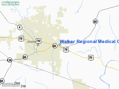
Walker Regional Medical Center Heliport |
Location
& QuickFacts
|
FAA Information Effective: |
2007-01-18 |
|
Airport
Identifier: |
AL63 |
|
Airport
Status: |
Operational |
|
Longitude/Latitude: |
087-14-02.0170W/33-50-36.3840N
-87.233894/33.843440 (Estimated) |
|
Elevation: |
418 ft / 127.41 m (Estimated) |
|
Land: |
0
acres |
|
From
nearest city: |
0 nautical miles W of Jasper, AL |
|
Location: |
Walker County, AL |
|
Magnetic Variation: |
00E (1990) |
Owner
& Manager
|
Ownership: |
Privately owned |
|
Owner: |
Walker Reg Medical Center Inc |
|
Address: |
3400 Hwy 78 E
Jasper, AL 35501 |
|
Phone number: |
205-387-4510 |
|
Manager: |
Charles Blackwood |
|
Address: |
3400 Hwy 78 E
Jasper, AL 35501 |
|
Phone number: |
205-387-4021 |
Airport
Operations and Facilities
|
Airport Use: |
Private
MEDICAL USE. |
|
Wind
indicator: |
Yes |
|
Segmented
Circle: |
No |
|
Control
Tower: |
No |
|
Sectional
chart: |
Atlanta |
|
Region: |
ASO - Southern |
|
Boundary
ARTCC: |
ZTL - Atlanta |
|
Tie-in
FSS: |
ANB - Anniston |
|
FSS
on Airport: |
No |
|
FSS
Toll Free: |
1-800-WX-BRIEF |
|
Runway Information
Helipad H1
|
Dimension: |
30
x 30 ft / 9.1 x 9.1 m |
|
Surface: |
CONC, |
|
|
Runway H1 |
Runway |
|
Traffic
Pattern: |
Left |
Left |
|
Radio Navigation
Aids
|
ID |
Type |
Name |
Ch |
Freq |
Var |
Dist |
|
BH |
NDB |
Mcden |
|
224.00 |
01W |
27.9 nm |
|
FDF |
NDB |
Fayette |
|
204.00 |
00E |
29.9 nm |
|
BEQ |
NDB |
Bessemer |
|
368.00 |
00E |
35.5 nm |
|
CPP |
NDB |
Cole Spring |
|
230.00 |
01W |
37.6 nm |
|
VUZ |
VORTAC |
Vulcan |
091X |
114.40 |
02E |
19.7 nm |
|
OKW |
VORTAC |
Brookwood |
047X |
111.00 |
00E |
36.3 nm |
|
LDK |
VORTAC |
Crimson |
125X |
117.80 |
03E |
38.3 nm |
|
HAB |
VORTAC |
Hamilton |
041X |
110.40 |
02E |
44.2 nm |
|
BHM |
VOT |
Birmingham Muni |
|
110.00 |
|
29.3 nm |
Remarks
- PRIVATE
USE; OPERATIONS ARE CONDUCTED FROM 85 DEGREES TO 95 DEGREES AND FROM
265 DEGREES TO 275 DEGREES; AREA IS MARKED; WIND INDICATOR IS MAINTAINED.
Walker Regional Medical Center Heliport
Address:
Walker County, AL
Tel:
205-387-4510, 205-387-4021
Images
and information placed above are from
http://www.airport-data.com/airport/AL63/
We
thank them for the data!
| General
Info |
| Country |
United
States |
| State |
ALABAMA
|
| FAA ID |
AL63
|
| Latitude |
33-50-36.384N
|
| Longitude |
087-14-02.017W
|
| Elevation |
418 feet
|
| Near City |
JASPER
|
We don't guarantee the information is fresh and accurate. The data may
be wrong or outdated.
For more up-to-date information please refer to other sources.
|
|


