|
|
Walker County - Bevill Field Airport |
Coordinates: 33°54′07″N 087°18′51″W / 33.90194°N 87.31417°W / 33.90194; -87.31417
Walker County Airport
Bevill Field |
 |
| IATA: none – ICAO: KJFX – FAA LID: JFX |
| Summary |
| Airport type |
Public |
| Owner |
Walker County Commission |
| Serves |
Jasper, Alabama |
| Elevation AMSL |
482 ft / 147 m |
| Runways |
| Direction |
Length |
Surface |
| ft |
m |
| 9/27 |
5,003 |
1,525 |
Asphalt |
| Statistics (2000) |
| Aircraft operations |
33,616 |
| Based aircraft |
55 |
| Source: Federal Aviation Administration |
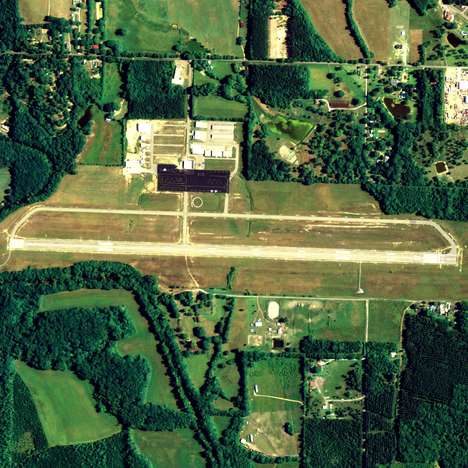
Walker County Airport (ICAO: KJFX, FAA LID: JFX, formerly L02), also known as Bevill Field, is a public airport located five miles (8 km) northwest of the central business district of Jasper, a city in Walker County, Alabama, United States. It is owned by the Walker County Commission.
Although most U.S. airports use the same three-letter location identifier for the FAA and IATA, Walker County Airport is assigned JFX by the FAA but has no designation from the IATA. Facilities and aircraft
Walker County Airport covers an area of 297 acres (120 ha) which contains one runway (9/27) with a 5,003 x 100 ft (1,525 x 30 m) asphalt pavement. For the 12-month period ending April 5, 2000, the airport had 33,616 aircraft operations, an average of 92 per day: 99.7% general aviation and 0.3% military. At that time there were 55 aircraft based at this airport: 87% single-engine, 9% multi-engine and 4% jet.
Air Resorts Airline Flight 953 accident
On December 16, 1984, Air Resorts Airlines Flight 953 experienced an in-flight engine failure, fire, and ground collision during the landing roll following an emergency landing at the airport. The flight was carrying the East Tennessee State University basketball team to Oxford, Mississippi from Birmingham, Alabama. Two of the 39 occupants of the Convair CV 440 airplane were seriously injured during the accident, 11 others received minor injuries. As the airport did not have on-field emergency services, the nearby Jasper Fire Department was called by the airport manager moments before the emergency landing after being alerted by the Birmingham Approach air traffic controller. During the landing the aircraft veered off Runway 27 and crossed the north-south taxiway, at which time the right landing gear separated and the airplane skidded to a stop. The aircraft was subsequently destroyed by fire. The NTSB concluded the accident resulted from the failure of the Number 6 cylinder in the right engine which caused a complete loss of power with a subsequent windmilling propeller and engine fire.
The above content comes from Wikipedia and is published under free licenses – click here to read more.
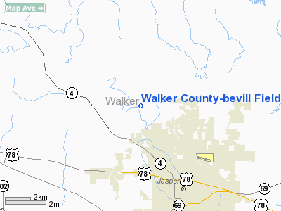
Location
& QuickFacts
|
FAA Information Effective: |
2007-01-18 |
|
Airport
Identifier: |
JFX |
|
Airport
Status: |
Operational |
|
Longitude/Latitude: |
087-18-51.0000W/33-54-07.1810N
-87.314167/33.901995 (Estimated) |
|
Elevation: |
482 ft / 146.91 m (Surveyed) |
|
Land: |
297 acres |
|
From
nearest city: |
5 nautical miles NW of Jasper, AL |
|
Location: |
Walker County, AL |
|
Magnetic Variation: |
00E (1985) |
Owner
& Manager
|
Ownership: |
Publicly owned |
|
Owner: |
Walker County Commission
BRUCE HAMRICK, CHAIRMAN. |
|
Address: |
P.o. Box 1447
Jasper, AL 35501 |
|
Phone
number: |
205-384-7230 |
|
Manager: |
Sammie Earnest |
|
Address: |
6 Ellis Haynes Dr
Jasper, AL 35503 |
|
Phone number: |
205-221-3342 |
Airport
Operations and Facilities
|
Airport Use: |
Open to public |
|
Wind
indicator: |
Yes |
|
Segmented
Circle: |
Yes |
|
Control
Tower: |
No |
|
Lighting
Schedule: |
DUSK-DAWN
ACTVT MIRL RY 09/27; VASI; AND REILS RYS 09 & 27 - CTAF. |
|
Beacon
Color: |
Clear-Green (lighted land airport) |
|
Landing
fee charge: |
No |
|
Sectional
chart: |
Atlanta |
|
Region: |
ASO - Southern |
|
Boundary
ARTCC: |
ZTL - Atlanta |
|
Tie-in
FSS: |
ANB - Anniston |
|
FSS
on Airport: |
No |
|
FSS
Toll Free: |
1-800-WX-BRIEF |
|
NOTAMs
Facility: |
ANB (NOTAM-d service avaliable) |
|
Federal Agreements: |
NGY |
Airport
Communications
|
CTAF: |
122.700 |
|
Unicom: |
122.700 |
Airport
Services
|
Fuel available: |
100LLA |
|
Airframe Repair: |
MAJOR |
|
Power Plant Repair: |
MAJOR |
|
Bottled
Oxygen: |
NONE |
|
Bulk
Oxygen: |
NONE |
|
Runway Information
Runway 09/27
|
Dimension: |
5003 x 100 ft / 1524.9 x 30.5 m |
|
Surface: |
ASPH, Good Condition |
|
Weight
Limit: |
Single wheel: 50000 lbs. |
|
Edge
Lights: |
Medium |
|
|
Runway 09 |
Runway 27 |
|
Longitude: |
087-19-19.3200W |
087-18-20.0400W |
|
Latitude: |
33-54-08.1600N |
33-54-06.5400N |
|
Elevation: |
482.00
ft |
475.00
ft |
|
Alignment: |
92 |
127 |
|
ILS
Type: |
|
ILS/DME |
|
Traffic
Pattern: |
Left |
Left |
|
Markings: |
Non-precision instrument, Good Condition |
Precision instrument, Good Condition |
|
Displaced
threshold: |
0.00 ft |
200.00
ft |
|
VASI: |
4-box on left side |
4-box on left side |
|
Runway
End Identifier: |
Yes |
Yes |
|
Decleard
distances: |
Take off run available 5001.00 ft
Take off distance available 5001.00 ft
Actual stop distance available 4800.00 ft
Landing distance available 4800.00 ft |
Take off run available 5001.00 ft
Take off distance available 5001.00 ft
Actual stop distance available 5001.00 ft
Landing distance available 4800.00 ft |
|
Radio Navigation
Aids
|
ID |
Type |
Name |
Ch |
Freq |
Var |
Dist |
|
FDF |
NDB |
Fayette |
|
204.00 |
00E |
27.3 nm |
|
BH |
NDB |
Mcden |
|
224.00 |
01W |
33.2 nm |
|
CPP |
NDB |
Cole Spring |
|
230.00 |
01W |
37.1 nm |
|
BEQ |
NDB |
Bessemer |
|
368.00 |
00E |
40.5 nm |
|
DCU |
VOR/DME |
Decatur |
075X |
112.80 |
01W |
48.6 nm |
|
VUZ |
VORTAC |
Vulcan |
091X |
114.40 |
02E |
25.0 nm |
|
HAB |
VORTAC |
Hamilton |
041X |
110.40 |
02E |
39.0 nm |
|
OKW |
VORTAC |
Brookwood |
047X |
111.00 |
00E |
39.9 nm |
|
LDK |
VORTAC |
Crimson |
125X |
117.80 |
03E |
40.2 nm |
|
MSL |
VORTAC |
Muscle Shoals |
112X |
116.50 |
01E |
49.2 nm |
|
BHM |
VOT |
Birmingham Muni |
|
110.00 |
|
34.6 nm |
Remarks
- DEER
ON & INVOF RYS.
- GCO
AVBL ON FREQ 121.725 THRU BIRMINGHAM (BHM) CLEARANCE DELIVERY.
Based
Aircraft
|
Aircraft
based on field: |
55 |
|
Single
Engine Airplanes: |
48 |
|
Multi
Engine Airplanes: |
5 |
|
Jet Engine
Airplanes: |
2 |
Operational Statistics
Time Period: 1999-04-07
- 2000-04-05
|
Aircraft
Operations: |
93/Day |
|
General
Aviation Local: |
14.3% |
|
General
Aviation Itinerant: |
85.4% |
|
Military: |
0.3% |
Walker County-bevill Field Airport
Address:
Walker County, AL
Tel:
205-384-7230,
205-221-3342
Images
and information placed above are from
http://www.airport-data.com/airport/JFX/
We
thank them for the data!
| General
Info |
| Country |
United
States |
| State |
ALABAMA
|
| FAA ID |
JFX
|
| Latitude |
33-54-07.183N
|
| Longitude |
087-18-50.999W
|
| Elevation |
482 feet
|
| Near City |
JASPER
|
We don't guarantee the information is fresh and accurate. The data may
be wrong or outdated.
For more up-to-date information please refer to other sources.
|
|