|
|
| Troy Municipal Airport |
 |
| IATA: TOI â ICAO: KTOI â FAA LID: TOI |
| Summary |
| Airport type |
Public |
| Owner |
City of Troy |
| Serves |
Troy, Alabama |
| Location |
Troy, Alabama |
| Elevation AMSL |
398 ft / 121.3 m |
| Coordinates |
31°51â²38â³N 086°00â²44â³W / 31.86056°N 86.01222°W / 31.86056; -86.01222 |
| Runways |
| Direction |
Length |
Surface |
| ft |
m |
| 14/32 |
5,022 |
1,531 |
Asphalt |
| 7/25 |
5,009 |
1,527 |
Asphalt |
| Statistics (2005) |
| Aircraft operations |
69,088 |
| Source: Federal Aviation Administration |
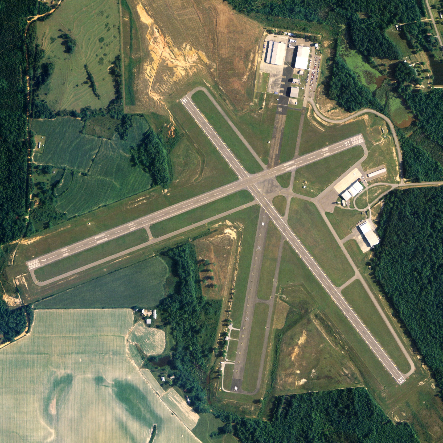
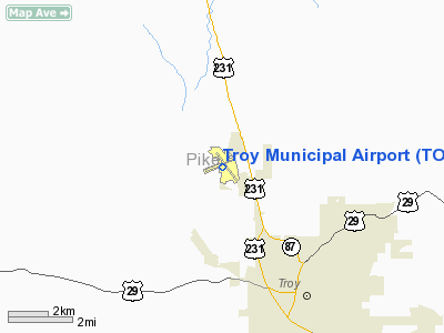
Troy Municipal Airport (IATA: TOI, ICAO: KTOI) is a city-owned public-use airport located 4 nautical miles (7 km) northwest of the central business district of Troy, a city in Pike County, Alabama, United States. Facilities and aircraft
Troy Municipal Airport covers an area of 501 acres (0.78 sq mi; 2.03 km) which contains two asphalt-paved runways: 14/32 measuring 5,022 by 100 feet (1,531 by 30 meters) and 7/25 measuring 5,009 by 100 feet (1,527 by 30 meters). The tower and radar facilities are run by Army air traffic controllers. The airport is dominated by study pilots flying TH-67s from Fort Rucker between the times of 800â1030L and 2:00â4:00PML. For the 12-month period ending December 29, 2005, the airport had 69,088 general aviation aircraft operations.
History
Activated on 11 January 1942 as a satellite airfield for the United States Army Air Forces Maxwell Field near Montgomery. Known as Maxwell AAF Aux No. 4 - Troy (aka Troy No. 5)
Also conducted basic flying training throughout the war. Flying training was performed with Fairchild PT-19s as the primary trainer. Also had several PT-17 Stearmans and a few P-40 Warhawks assigned. Transferred as inactive to the US Army Corps of Engineers on 1 April 1946 with the drawdown of AAFTC's pilot training program.
The airfield was turned over to civil control though the War Assets Administration (WAA).
The above content comes from Wikipedia and is published under free licenses – click here to read more.
Location
& QuickFacts
|
FAA Information Effective: |
2007-01-18 |
|
Airport
Identifier: |
TOI |
|
Airport
Status: |
Operational |
|
Longitude/Latitude: |
086-00-43.7000W/31-51-37.5000N
-86.012139/31.860417 (Estimated) |
|
Elevation: |
398 ft / 121.31 m (Surveyed) |
|
Land: |
501 acres |
|
From
nearest city: |
4 nautical miles NW of Troy, AL |
|
Location: |
Pike County, AL |
|
Magnetic Variation: |
01W (1990) |
Owner
& Manager
|
Ownership: |
Publicly owned |
|
Owner: |
City Of Troy |
|
Address: |
Po Box 549
Troy, AL 36081 |
|
Phone number: |
334-566-0177 |
|
Manager: |
Trent Crawford |
|
Address: |
301 Airport Road
Troy, AL 36079 |
|
Phone number: |
334-566-3470 |
Airport
Operations and Facilities
|
Airport Use: |
Open to public |
|
Wind
indicator: |
Yes |
|
Segmented
Circle: |
No |
|
Control
Tower: |
Yes |
|
Lighting
Schedule: |
DUSK-DAWN
ACTVT MIRL RY 07/25 & 14/32 AND VASI RY 25 - CTAF. |
|
Beacon
Color: |
Clear-Green (lighted land airport) |
|
Landing
fee charge: |
No |
|
Sectional
chart: |
New Orleans |
|
Region: |
ASO - Southern |
|
Boundary
ARTCC: |
ZTL - Atlanta |
|
Responsible
ARTCC: |
ZJX - Jacksonville |
|
Tie-in
FSS: |
ANB - Anniston |
|
FSS
on Airport: |
No |
|
FSS
Toll Free: |
1-800-WX-BRIEF |
|
NOTAMs
Facility: |
TOI (NOTAM-d service avaliable) |
|
Federal Agreements: |
NGY3 |
Airport
Communications
|
CTAF: |
122.800 |
|
Unicom: |
122.800 |
Airport
Services
|
Fuel available: |
100LLA
FUEL AVBL 0800-0030 MON-FRI, 0800-1700 SAT-SUN; AFT HRS
CALL 334-372-0885. |
|
Airframe Repair: |
MAJOR |
|
Power Plant Repair: |
MAJOR |
|
Bottled
Oxygen: |
NONE |
|
Bulk
Oxygen: |
NONE |
|
Runway Information
Runway 07/25
|
Dimension: |
5009
x 100 ft / 1526.7 x 30.5 m
25 FT PAVED SHOULDERS. |
|
Surface: |
ASPH, Good Condition |
|
Weight
Limit: |
Single wheel: 24000 lbs.
Dual wheel: 80000 lbs.
Dual
tandem wheel: 140000 lbs. |
|
Edge
Lights: |
Medium
RWY 14/32 MIRL LCTD 35' FM RY EDGE. |
|
|
Runway 07 |
Runway 25 |
|
Longitude: |
086-01-18.8000W |
086-00-24.4100W |
|
Latitude: |
31-51-31.4900N |
31-51-48.8600N |
|
Elevation: |
389.00
ft |
394.00
ft |
|
Alignment: |
69 |
127 |
|
ILS
Type: |
ILS |
|
|
Traffic
Pattern: |
Left |
Left |
|
Markings: |
Precision instrument, Good Condition |
Precision instrument, Good Condition |
|
Crossing
Height: |
0.00 ft |
44.00
ft |
|
VASI: |
|
4-box on right side |
|
Visual
Glide Angle: |
0.00° |
3.00° |
|
Obstruction: |
40 ft trees, 1156.0 ft from runway, 142 ft
left of centerline, 23:1 slope to clear |
65 ft trees, 1500.0 ft from runway, 130 ft
right of centerline, 20:1 slope to clear |
|
Runway 14/32
|
Dimension: |
5022
x 100 ft / 1530.7 x 30.5 m
25 FT PAVED SHOULDERS. |
|
Surface: |
ASPH, Good Condition |
|
Weight
Limit: |
Single wheel: 24000 lbs.
Dual wheel: 80000 lbs.
Dual
tandem wheel: 140000 lbs. |
|
Edge
Lights: |
Non-standard lighting system
RWY 14/32 MIRL LCTD 35' FM RY EDGE. |
|
|
Runway 14 |
Runway 32 |
|
Longitude: |
086-00-53.4700W |
086-00-18.3400W |
|
Latitude: |
31-51-54.6300N |
31-51-15.0000N |
|
Elevation: |
398.00
ft |
366.00
ft |
|
Alignment: |
127 |
127 |
|
Traffic
Pattern: |
Left |
Left |
|
Markings: |
Basic, Poor Condition
MARKINGS FADED. |
Basic, Fair Condition |
|
Obstruction: |
50 ft trees, 1716.0 ft from runway, 40 ft left
of centerline, 30:1 slope to clear |
51 ft tree, 1195.0 ft from runway, 173 ft right
of centerline, 19:1 slope to clear |
|
Radio Navigation
Aids
|
ID |
Type |
Name |
Ch |
Freq |
Var |
Dist |
|
TO |
NDB |
Blood |
|
365.00 |
01W |
5.1 nm |
|
XNE |
NDB |
Spring Hill |
|
281.00 |
00E |
10.8 nm |
|
XBR |
NDB |
Brantley |
|
410.00 |
00E |
23.0 nm |
|
PRN |
NDB |
Persimmon/dcmsnd |
|
359.00 |
00E |
30.8 nm |
|
BVG |
NDB |
Boll Weevil |
|
352.00 |
03E |
31.5 nm |
|
LOR |
NDB |
Lowe |
|
269.00 |
03W |
33.1 nm |
|
HYE |
NDB |
Hanchey |
|
221.00 |
00E |
35.0 nm |
|
JUY |
NDB |
Judd |
|
264.00 |
02W |
38.6 nm |
|
OZ |
NDB |
Ruckr |
|
212.00 |
00E |
39.5 nm |
|
MXF |
TACAN |
Maxwell |
097X |
|
03E |
36.1 nm |
|
EDN |
VOR |
Enterprise |
|
116.60 |
03W |
34.4 nm |
|
HEY |
VOR |
Hanchey |
|
110.60 |
02E |
34.5 nm |
|
UIA |
VOR |
Andalusia |
|
110.20 |
00E |
38.4 nm |
|
OZR |
VOR/DME |
Cairns |
049X |
111.20 |
02E |
38.4 nm |
|
TGE |
VOR/DME |
Tuskegee |
120X |
117.30 |
02E |
41.4 nm |
|
MGM |
VORTAC |
Montgomery |
058X |
112.10 |
03E |
26.8 nm |
|
EUF |
VORTAC |
Eufaula |
029X |
109.20 |
02E |
45.3 nm |
|
RRS |
VORTAC |
Wiregrass |
053X |
111.60 |
02E |
45.6 nm |
Remarks
- EXTSV
HEL AND FLT TRNG OPNS INVOF ARPT 0630-1700 MON-FRI EXCP HOL.
- NO
RUNNING LANDINGS ON RY OR TWY BY SKID-EQUIPPED HELOCOPTERS.
- WX
OBSERVER AVBL 1230-0230Z++ MON-FRI, EXC HOL. CTC CAIRNS AAF FOR FCST
0600Z++ MON-0700Z++ SAT, EXC HOL. WX OBSN VIS RSTD N-SE. REMOTE BRIEFING
SVC AVBL 9TH OWS, SHAW AFB, DSN 965-0939/43, C877-297-4129 (TOLL FREE)
HTTPS://OWS.SHAW.AF.MIL
- NO
ARR/DEP TO/FROM N HELIPAD OVER FBO RAMP.
Based Aircraft
|
Aircraft
based on field: |
48 |
|
Single
Engine Airplanes: |
28 |
|
Multi
Engine Airplanes: |
10 |
|
Jet Engine
Airplanes: |
6 |
|
Ultralights: |
4 |
Operational Statistics
Time Period: 2004-12-30
- 2005-12-29
|
Aircraft
Operations: |
190/Day |
|
General
Aviation Local: |
12.9% |
|
General
Aviation Itinerant: |
46.3% |
|
Military: |
40.8% |
Troy Municipal Airport
Address:
Pike County, AL
Tel:
334-566-0177, 334-566-3470
Images
and information placed above are from
http://www.airport-data.com/airport/TOI/
We
thank them for the data!
| General
Info |
| Country |
United
States |
| State |
ALABAMA
|
| FAA ID |
TOI
|
| Latitude |
31-51-37.500N
|
| Longitude |
086-00-43.700W
|
| Elevation |
397 feet
|
| Near City |
TROY
|
We don't guarantee the information is fresh and accurate. The data may
be wrong or outdated.
For more up-to-date information please refer to other sources.
|
|