 |
|
Talladega Municipal Airport |
| Talladega Municipal Airport |
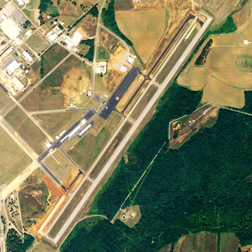 |
| NAIP aerial image, 21 June 2006 |
| IATA: ASN â ICAO: KASN â FAA LID: ASN |
| Summary |
| Airport type |
Public |
| Owner |
City of Talladega |
| Serves |
Talladega, Alabama |
| Elevation AMSL |
529 ft / 161 m |
| Coordinates |
33°34â²10â³N 086°03â²04â³W / 33.56944°N 86.05111°W / 33.56944; -86.05111 |
| Runways |
| Direction |
Length |
Surface |
| ft |
m |
| 3/21 |
6,001 |
1,829 |
Asphalt |
| Statistics (2008) |
| Aircraft operations |
41,000 |
| Based aircraft |
44 |
| Source: Federal Aviation Administration |
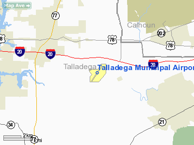
Talladega Municipal Airport (IATA: ASN, ICAO: KASN, FAA LID: ASN) is a public use airport located eight nautical miles (15 km) northeast of the central business district of Talladega, a city in Talladega County, Alabama, United States. This general aviation airport is publicly owned by the City of Talladega.
Facilities and aircraft
Talladega Municipal Airport covers an area of 1,029 acres (416 ha) at an elevation of 529 feet (161 m) above mean sea level. It has one asphalt paved runway designated 3/21 which measures 6,001 by 100 feet (1,829 x 30 m).
For the 12-month period ending December 31, 2008, the airport had 41,000 aircraft operations, an average of 112 per day: 92% general aviation, 7% military and 2% air taxi. At that time there were 44 aircraft based at this airport: 95% single-engine, 2% jet and 2% ultralight.
The above content comes from Wikipedia and is published under free licenses – click here to read more.
Location
& QuickFacts
|
FAA Information Effective: |
2007-01-18 |
|
Airport
Identifier: |
ASN |
|
Airport
Status: |
Operational |
|
Longitude/Latitude: |
086-03-03.1000W/33-34-11.7000N
-86.050861/33.569917 (Estimated) |
|
Elevation: |
529 ft / 161.24 m (Surveyed) |
|
Land: |
1029 acres |
|
From
nearest city: |
8 nautical miles NE of Talladega, AL |
|
Location: |
Talladega County, AL |
|
Magnetic Variation: |
01W (1985) |
Owner
& Manager
|
Ownership: |
Publicly owned |
|
Owner: |
City Of Talladega |
|
Address: |
City Hall
Talladega, AL 35160 |
|
Phone number: |
256-362-8775 |
|
Manager: |
Jim Brock |
|
Address: |
Po Box 777
Talladega, AL 35160 |
|
Phone number: |
256-761-4815 |
Airport
Operations and Facilities
|
Airport Use: |
Open to public |
|
Wind
indicator: |
Yes |
|
Segmented
Circle: |
Yes |
|
Control
Tower: |
No |
|
Lighting
Schedule: |
DUSK-DAWN |
|
Beacon
Color: |
Clear-Green (lighted land airport) |
|
Landing
fee charge: |
No |
|
Sectional
chart: |
Atlanta |
|
Region: |
ASO - Southern |
|
Boundary
ARTCC: |
ZTL - Atlanta |
|
Tie-in
FSS: |
ANB - Anniston |
|
FSS
on Airport: |
No |
|
FSS
Toll Free: |
1-800-WX-BRIEF |
|
NOTAMs
Facility: |
ANB (NOTAM-d service avaliable) |
|
Certification
type/date: |
I L U 04/1976
CLSD TO ACR OPNS WITH MORE THAN 30 PSGR SEATS EXCP PPR CALL
AMGR (256) 761-4815. |
|
Federal Agreements: |
NGPY |
Airport
Communications
|
CTAF: |
122.800 |
|
Unicom: |
122.800 |
Airport
Services
|
Fuel available: |
100LLA |
|
Airframe Repair: |
MAJOR |
|
Power Plant Repair: |
MAJOR |
|
Bottled
Oxygen: |
NONE |
|
Bulk
Oxygen: |
NONE |
|
Runway Information
Runway 03/21
|
Dimension: |
6001 x 100 ft / 1829.1 x 30.5 m |
|
Surface: |
ASPH, Good Condition |
|
Surface
Treatment: |
Saw-cut or plastic Grooved |
|
Weight
Limit: |
Single wheel: 30000 lbs.
Dual wheel: 65000 lbs.
Dual
tandem wheel: 95000 lbs. |
|
Edge
Lights: |
Medium
OTS INDEFLY. |
|
|
Runway 03 |
Runway 21 |
|
Longitude: |
086-03-23.5963W |
086-02-42.5270W |
|
Latitude: |
33-33-47.5057N |
33-34-35.9095N |
|
Elevation: |
510.00
ft |
529.00
ft |
|
Alignment: |
35 |
127 |
|
Traffic
Pattern: |
Right |
Left |
|
Markings: |
Non-precision instrument, Fair Condition |
Non-precision instrument, Poor Condition |
|
Crossing
Height: |
47.00
ft |
43.00
ft |
|
VASI: |
4-box on left side |
4-box on left side |
|
Visual
Glide Angle: |
3.00° |
3.00° |
|
Obstruction: |
, 50:1 slope to clear |
45 ft trees, 1800.0 ft from runway, 200 ft
left of centerline, 34:1 slope to clear |
|
Radio Navigation
Aids
|
ID |
Type |
Name |
Ch |
Freq |
Var |
Dist |
|
PLR |
NDB |
Pell City |
|
257.00 |
01E |
10.0 nm |
|
SCD |
NDB |
Sylacauga |
|
284.00 |
03W |
27.3 nm |
|
BH |
NDB |
Mcden |
|
224.00 |
01W |
40.0 nm |
|
DER |
NDB |
Alexander City |
|
382.00 |
01W |
41.8 nm |
|
ARF |
NDB |
Saratoga |
|
296.00 |
02W |
41.9 nm |
|
GPQ |
NDB |
Carrollton |
|
278.00 |
02W |
46.1 nm |
|
BEQ |
NDB |
Bessemer |
|
368.00 |
00E |
46.4 nm |
|
TDG |
VOR/DME |
Talladega |
025X |
108.80 |
02E |
0.5 nm |
|
GAD |
VOR/DME |
Gadsden |
070X |
112.30 |
02E |
24.5 nm |
|
VUZ |
VORTAC |
Vulcan |
091X |
114.40 |
02E |
42.9 nm |
|
BHM |
VOT |
Birmingham Muni |
|
110.00 |
|
35.3 nm |
Remarks
- TMPRY
ATCT BY NOTAM FOR SPECIAL EVENTS.
- DEER
ON & INVOF ARPT.
Based
Aircraft
|
Aircraft
based on field: |
48 |
|
Single
Engine Airplanes: |
42 |
|
Multi
Engine Airplanes: |
1 |
|
Jet Engine
Airplanes: |
1 |
|
Helicopters: |
3 |
|
Ultralights: |
1 |
Operational Statistics
Time Period: 2004-01-02
- 2004-12-31
|
Aircraft
Operations: |
113/Day |
|
Air Taxi: |
1.5% |
|
General
Aviation Local: |
2.9% |
|
General
Aviation Itinerant: |
89.0% |
|
Military: |
6.6% |
Talladega Municipal Airport
Address:
Talladega County, AL
Tel:
256-362-8775, 256-761-4815
Images
and information placed above are from
http://www.airport-data.com/airport/ASN/
We
thank them for the data!
| General
Info |
| Country |
United
States |
| State |
ALABAMA
|
| FAA ID |
ASN
|
| Latitude |
33-34-11.680N
|
| Longitude |
086-03-03.090W
|
| Elevation |
528 feet
|
| Near City |
TALLADEGA
|
We don't guarantee the information is fresh and accurate. The data may
be wrong or outdated.
For more up-to-date information please refer to other sources.
|
|


