 |
|
| NOLF Summerdale |
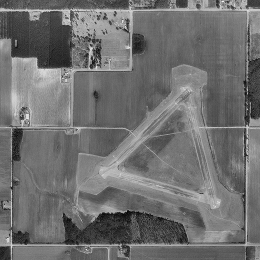 |
| USGS aerial image - 17 February 1997 |
| IATA: none – ICAO: KNFD – FAA LID: NFD |
| Summary |
| Airport type |
Military |
| Owner |
U.S. Navy |
| Location |
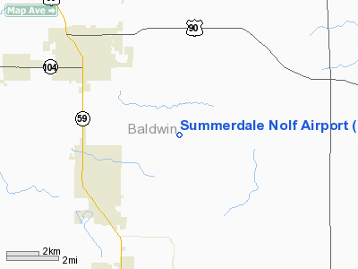
Baldwin County, near Summerdale, Alabama |
| Elevation AMSL |
149 ft / 45 m |
| Coordinates |
30°30′28″N 087°38′44″W / 30.50778°N 87.64556°W / 30.50778; -87.64556 |
| Runways |
| Direction |
Length |
Surface |
| ft |
m |
| 4/22 |
2,850 |
869 |
Asphalt |
| 10/28 |
2,850 |
869 |
Asphalt |
| 16/34 |
2,850 |
869 |
Asphalt |
| Source: Federal Aviation Administration |
Naval Outlying Field Summerdale (ICAO: KNFD, FAA LID: NFD) is a military use airport located in Summerdale, a town in Baldwin County, Alabama, United States.
Although many U.S. airports use the same three-letter location identifier for the FAA and IATA, this airport is assigned NFD by the FAA but has no designation from the IATA.
Facilities
NOLF Summerdale has three asphalt paved runways, each measuring 2,850 by 150 feet (869 x 46 m): Runway 4/22, Runway 10/28, and Runway 16/34.
The above content comes from Wikipedia and is published under free licenses – click here to read more.
Location
& QuickFacts
|
FAA Information Effective: |
2007-01-18 |
|
Airport
Identifier: |
NFD |
|
Airport
Status: |
Operational |
|
Longitude/Latitude: |
087-38-43.9480W/30-30-27.7020N
-87.645541/30.507695 (Estimated) |
|
Elevation: |
149 ft / 45.42 m (Estimated) |
|
Land: |
0
acres |
|
From
nearest city: |
0 nautical miles of Summerdale, AL |
|
Location: |
Wilcox County, AL |
|
Magnetic Variation: |
01E (1985) |
Owner
& Manager
|
Ownership: |
Navy owned |
|
Owner: |
Unknown |
|
Address: |
|
|
Manager: |
Commanding Officer |
|
Address: |
Operations Department, 7077 Uss Lexington
Court
Milton, FL 32570-6016 |
Airport
Operations and Facilities
|
Airport Use: |
Private |
|
Segmented Circle: |
No |
|
Control Tower: |
No |
|
Sectional chart: |
New Orleans |
|
Region: |
ASO - Southern |
|
Boundary ARTCC: |
ZJX - Jacksonville |
|
Tie-in FSS: |
ANB - Anniston |
|
FSS Toll Free: |
1-800-WX-BRIEF |
Airport
Communications
|
Runway Information
Runway 04/22
|
Dimension: |
2850 x 150 ft / 868.7 x 45.7 m |
|
Surface: |
ASPH, |
|
Pavement
Class: |
24 /F/B/W/U |
|
|
Runway 04 |
Runway 22 |
|
Traffic
Pattern: |
Left |
Left |
|
Runway 10/28
|
Dimension: |
2850 x 150 ft / 868.7 x 45.7 m |
|
Surface: |
ASPH, |
|
Pavement
Class: |
24 /F/B/W/U |
|
|
Runway 10 |
Runway 28 |
|
Traffic
Pattern: |
Left |
Left |
|
Runway 16/34
|
Dimension: |
2850 x 150 ft / 868.7 x 45.7 m |
|
Surface: |
ASPH, |
|
Pavement
Class: |
24 /F/B/W/U |
|
|
Runway 16 |
Runway 34 |
|
Traffic
Pattern: |
Left |
Left |
|
Radio Navigation
Aids
|
ID |
Type |
Name |
Ch |
Freq |
Var |
Dist |
|
ESU |
NDB |
Summerdale |
|
204.00 |
01E |
4.2 nm |
|
PKZ |
NDB |
Pickens |
|
326.00 |
01E |
24.6 nm |
|
MO |
NDB |
Wisle |
|
248.00 |
02E |
37.3 nm |
|
NPA |
TACAN |
Pensacola |
119X |
|
01E |
19.3 nm |
|
NSE |
TACAN |
Whiting |
070X |
|
01E |
35.0 nm |
|
NGS |
TACAN |
Santa Rosa |
063X |
|
01E |
37.2 nm |
|
HRT |
TACAN |
Hurlburt |
045X |
|
00E |
49.7 nm |
|
NUN |
VOR |
Saufley |
|
108.80 |
01E |
16.2 nm |
|
BFM |
VORTAC |
Brookley |
075X |
112.80 |
04E |
22.1 nm |
|
SJI |
VORTAC |
Semmes |
100X |
115.30 |
05E |
39.2 nm |
Remarks
- CONTROLLING
AGENCY NAS WHITING FLD.
- SINGLE
ACFT, LOW APCH ONLY.
- RSTD:
MIL USE ONLY.
Summerdale Nolf Airport
Address:
Wilcox County, AL
Tel:
Images
and information placed above are from
http://www.airport-data.com/airport/NFD/
We
thank them for the data!
| General
Info |
| Country |
United
States |
| State |
ALABAMA
|
| FAA ID |
NFD
|
| Latitude |
30-30-27.702N
|
| Longitude |
087-38-43.948W
|
| Elevation |
149 feet
|
| Near City |
SUMMERDALE
|
We don't guarantee the information is fresh and accurate. The data may
be wrong or outdated.
For more up-to-date information please refer to other sources.
|
|


