 |
|
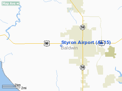
Location
& QuickFacts
|
FAA Information Effective: |
2007-01-18 |
|
Airport
Identifier: |
AL15 |
|
Airport
Status: |
Operational |
|
Longitude/Latitude: |
087-43-26.9550W/30-24-10.7120N
-87.724154/30.402976 (Estimated) |
|
Elevation: |
120 ft / 36.58 m (Estimated) |
|
Land: |
0
acres |
|
From
nearest city: |
3 nautical miles W of Foley, AL |
|
Location: |
Baldwin County, AL |
|
Magnetic Variation: |
01E (1985) |
Owner
& Manager
|
Ownership: |
Privately owned |
|
Owner: |
Samuel M. Styron |
|
Address: |
Po Box 1318
Foley, AL 36536 |
|
Phone number: |
205-943-5525 |
|
Manager: |
Samuel M. Styron |
|
Address: |
Po Box 1318
Foley, AL 36536 |
|
Phone number: |
205-943-5525 |
Airport
Operations and Facilities
|
Airport Use: |
Private |
|
Segmented
Circle: |
No |
|
Control
Tower: |
No |
|
Sectional
chart: |
New Orleans |
|
Region: |
ASO - Southern |
|
Boundary
ARTCC: |
ZJX - Jacksonville |
|
Tie-in
FSS: |
ANB - Anniston |
|
FSS
on Airport: |
No |
|
FSS
Toll Free: |
1-800-WX-BRIEF |
|
Runway
Information
Runway N/S
|
Dimension: |
2600 x 80 ft / 792.5 x 24.4 m |
|
Surface: |
TURF, |
|
|
Runway N |
Runway S |
|
Traffic
Pattern: |
Left |
Left |
|
Radio Navigation
Aids
|
ID |
Type |
Name |
Ch |
Freq |
Var |
Dist |
|
ESU |
NDB |
Summerdale |
|
204.00 |
01E |
5.8 nm |
|
PKZ |
NDB |
Pickens |
|
326.00 |
01E |
28.4 nm |
|
MO |
NDB |
Wisle |
|
248.00 |
02E |
36.9 nm |
|
NPA |
TACAN |
Pensacola |
119X |
|
01E |
21.3 nm |
|
NSE |
TACAN |
Whiting |
070X |
|
01E |
41.3 nm |
|
NGS |
TACAN |
Santa Rosa |
063X |
|
01E |
42.7 nm |
|
NUN |
VOR |
Saufley |
|
108.80 |
01E |
20.5 nm |
|
BFM |
VORTAC |
Brookley |
075X |
112.80 |
04E |
21.3 nm |
|
SJI |
VORTAC |
Semmes |
100X |
115.30 |
05E |
38.2 nm |
Remarks
- VFR
ONLY; PVT USE & TFC PTN IS ESTABLISHED ON W SIDE OF THE ARPT.
Styron Airport
Address:
Baldwin County, AL
Tel:
205-943-5525
Images
and information placed above are from
http://www.airport-data.com/airport/AL15/
We
thank them for the data!
| General
Info |
| Country |
United
States |
| State |
ALABAMA
|
| FAA ID |
AL15
|
| Latitude |
30-24-10.712N
|
| Longitude |
087-43-26.955W
|
| Elevation |
120 feet
|
| Near City |
FOLEY
|
We don't guarantee the information is fresh and accurate. The data may
be wrong or outdated.
For more up-to-date information please refer to other sources.
|
|


