 |
|
| St. Elmo Airport |
 |
| IATA: none – ICAO: none – FAA LID: 2R5 |
| Summary |
| Airport type |
Public |
| Owner |
State of Alabama |
| Serves |
St. Elmo, Alabama |
| Elevation AMSL |
132 ft / 40.2 m |
| Coordinates |
30°30′07″N 088°16′30″W / 30.50194°N 88.275°W / 30.50194; -88.275 |
| Runways |
| Direction |
Length |
Surface |
| ft |
m |
| 6/24 |
3,998 |
1,219 |
Asphalt |
| Statistics (2006) |
| Aircraft operations |
20,400 |
| Source: Federal Aviation Administration |
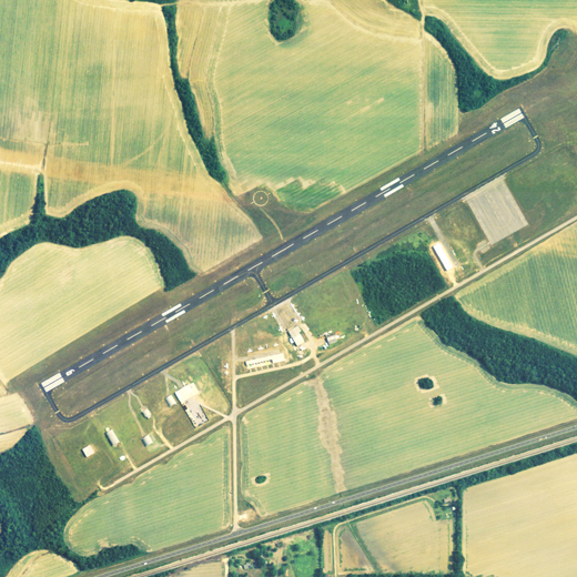
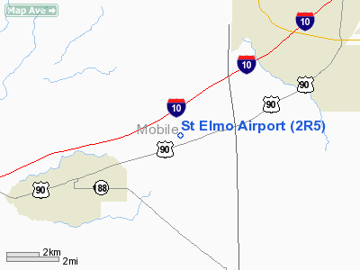
St. Elmo Airport (FAA LID: 2R5) is a state-owned public-use airport located 2 nautical miles (4 km) west of the central business district of St. Elmo, in Mobile County, Alabama, United States.
Facilities and aircraft
St. Elmo Airport covers an area of 733 acres (1.15 sq mi; 2.97 km) which contains one runway designated 6/24 is 3,998 x 80 feet (1,219 x 24 meters) asphalt pavement. For the 12-month period ending June 6, 2006, the airport had 20,400 general aviation aircraft operations.
The above content comes from Wikipedia and is published under free licenses – click here to read more.
Location
& QuickFacts
|
FAA Information Effective: |
2007-01-18 |
|
Airport
Identifier: |
2R5 |
|
Airport
Status: |
Operational |
|
Longitude/Latitude: |
088-16-30.4500W/30-30-06.8700N
-88.275125/30.501908 (Estimated) |
|
Elevation: |
133 ft / 40.54 m (Surveyed) |
|
Land: |
733 acres |
|
From
nearest city: |
2 nautical miles W of St Elmo, AL |
|
Location: |
Mobile County, AL |
|
Magnetic Variation: |
02E (1985) |
Owner
& Manager
|
Ownership: |
Publicly owned |
|
Owner: |
State Of Alabama |
|
Address: |
1409 Coliseum Blvd
Montgomery, AL 36130 |
|
Phone
number: |
334-242-6820 |
|
Manager: |
Frank Farmer
ALABAMA DEPARTMENT OF TRANSPORTATION, AERONAUTICS BUREAU.. |
|
Address: |
1409 Coliseum Blvd
Montgomery, AL 36130 |
|
Phone number: |
334-242-6820 |
Airport
Operations and Facilities
|
Airport Use: |
Open to public |
|
Wind
indicator: |
Yes |
|
Segmented
Circle: |
Yes |
|
Control
Tower: |
No |
|
Lighting
Schedule: |
DUSK-DAWN
ACTVT MIRL RY 06/24 - 122.75. |
|
Beacon
Color: |
Clear-Green (lighted land airport) |
|
Landing
fee charge: |
No |
|
Sectional
chart: |
New Orleans |
|
Region: |
ASO - Southern |
|
Boundary
ARTCC: |
ZHU - Houston |
|
Tie-in
FSS: |
ANB - Anniston |
|
FSS
on Airport: |
No |
|
FSS
Toll Free: |
1-800-WX-BRIEF |
|
NOTAMs
Facility: |
ANB (NOTAM-d service avaliable) |
|
Federal Agreements: |
NR |
Airport
Communications
Airport
Services
|
Fuel available: |
100LL |
|
Airframe Repair: |
MAJOR |
|
Power Plant Repair: |
MAJOR |
|
Bottled
Oxygen: |
NONE |
|
Bulk
Oxygen: |
NONE |
|
Runway Information
Runway 06/24
|
Dimension: |
3997 x 80 ft / 1218.3 x 24.4 m |
|
Surface: |
ASPH, Good Condition |
|
Weight
Limit: |
Single wheel: 23000 lbs. |
|
Edge
Lights: |
Medium |
|
|
Runway 06 |
Runway 24 |
|
Longitude: |
088-16-50.1300W |
088-16-10.7700W |
|
Latitude: |
30-29-56.8000N |
30-30-16.9400N |
|
Elevation: |
130.00
ft |
131.00
ft |
|
Alignment: |
59 |
127 |
|
Traffic
Pattern: |
Left |
Left |
|
Markings: |
Basic, Good Condition |
Basic, Good Condition |
|
Obstruction: |
34 ft trees, 1076.0 ft from runway, 25:1 slope
to clear |
45 ft trees, 1500.0 ft from runway, 28:1 slope
to clear |
|
Radio Navigation
Aids
|
ID |
Type |
Name |
Ch |
Freq |
Var |
Dist |
|
MO |
NDB |
Wisle |
|
248.00 |
02E |
15.6 nm |
|
ESU |
NDB |
Summerdale |
|
204.00 |
01E |
28.4 nm |
|
BIX |
TACAN |
Keesler |
055X |
|
01E |
34.4 nm |
|
NUN |
VOR |
Saufley |
|
108.80 |
01E |
48.7 nm |
|
GPT |
VOR/DME |
Gulfport |
27X |
109.00 |
02E |
41.9 nm |
|
BFM |
VORTAC |
Brookley |
075X |
112.80 |
04E |
13.2 nm |
|
SJI |
VORTAC |
Semmes |
100X |
115.30 |
05E |
14.2 nm |
|
GCV |
VORTAC |
Greene County |
104X |
115.70 |
05E |
37.4 nm |
Remarks
Based
Aircraft
|
Aircraft
based on field: |
37 |
|
Single
Engine Airplanes: |
29 |
|
Multi
Engine Airplanes: |
3 |
|
Helicopters: |
5 |
Operational Statistics
Time Period: 2005-06-07
- 2006-06-06
|
Aircraft
Operations: |
56/Day |
|
General
Aviation Local: |
38.7% |
|
General
Aviation Itinerant: |
61.3% |
St Elmo Airport
Address:
Mobile County, AL
Tel:
334-242-6820
Images
and information placed above are from
http://www.airport-data.com/airport/2R5/
We
thank them for the data!
| General
Info |
| Country |
United
States |
| State |
ALABAMA
|
| FAA ID |
2R5
|
| Latitude |
30-30-06.870N
|
| Longitude |
088-16-30.420W
|
| Elevation |
133 feet
|
| Near City |
ST ELMO
|
We don't guarantee the information is fresh and accurate. The data may
be wrong or outdated.
For more up-to-date information please refer to other sources.
|
|


