 |
|
| St. Clair County Airport |
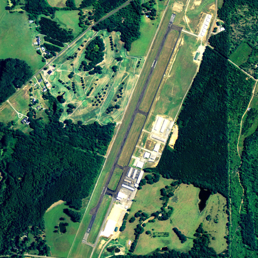 |
| NAIP aerial image, 2006 |
| IATA: PLR â ICAO: KPLR â FAA LID: PLR |
| Summary |
| Airport type |
Public |
| Owner |
St. Clair County Airport Authority |
| Serves |
Pell City, Alabama |
| Elevation AMSL |
485 ft / 148 m |
| Coordinates |
33°33â²32â³N 086°14â²57â³W / 33.55889°N 86.24917°W / 33.55889; -86.24917 |
| Website |
www.PLRairport.com |
| Runways |
| Direction |
Length |
Surface |
| ft |
m |
| 3/21 |
5,001 |
1,524 |
Asphalt |
| Statistics (2009) |
| Aircraft operations |
34,572 |
| Based aircraft |
81 |
| Source: Federal Aviation Administration |
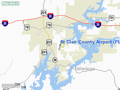
St. Clair County Airport (IATA: PLR, ICAO: KPLR, FAA LID: PLR) is a public use airport located three nautical miles (6 km) southeast of the central business district of Pell City, in St. Clair County, Alabama, United States. It is owned by the St. Clair County Airport Authority. According to the FAA's National Plan of Integrated Airport Systems for 2009â2013, it is categorized as a reliever airport. for the Birmingham-Shuttlesworth International Airport.
Facilities and aircraft
St. Clair County Airport covers an area of 200 acres (81 ha) at an elevation of 485 feet (148 m) above mean sea level. It has one runway designated 3/21 with an asphalt surface measuring 5,001 by 80 feet (1,524 x 24 m).
For the 12-month period ending January 22, 2009, the airport had 34,572 aircraft operations, an average of 94 per day: 97% general aviation and 3% military. At that time there were 81 aircraft based at this airport: 85% single-engine, 12% multi-engine, 1% helicopter and 1% ultralight.
Sammies Touch-n-Go restaurant is located on the North end of the airport.
The above content comes from Wikipedia and is published under free licenses – click here to read more.
Location
& QuickFacts
|
FAA Information Effective: |
2007-01-18 |
|
Airport
Identifier: |
PLR |
|
Airport
Status: |
Operational |
|
Longitude/Latitude: |
086-14-56.6000W/33-33-31.8000N
-86.249056/33.558833 (Estimated) |
|
Elevation: |
485 ft / 147.83 m (Surveyed) |
|
Land: |
200 acres |
|
From
nearest city: |
3 nautical miles SE of Pell City, AL |
|
Location: |
St Clair County, AL |
|
Magnetic Variation: |
03W (2005) |
Owner
& Manager
|
Ownership: |
Publicly owned |
|
Owner: |
St Clair Co Arpt Auth
CONTACT PERSON: MIKE FRICKER; CHAIRMAN ST.
CLAIR
COUNTY ARPT AUTHORITY. |
|
Address: |
Po Box 36
Cropwell, AL 35054 |
|
Phone
number: |
205-338-9456 |
|
Manager: |
Bill Walker |
|
Address: |
240 Airport Road
Pell City, AL 35128 |
|
Phone number: |
205-338-9456 |
Airport
Operations and Facilities
|
Airport Use: |
Open to public |
|
Wind
indicator: |
Yes |
|
Segmented
Circle: |
No |
|
Control
Tower: |
No |
|
Lighting
Schedule: |
DUSK-DAWN
ACTVT MIRL RY 02/20 - CTAF. |
|
Beacon
Color: |
Clear-Green (lighted land airport) |
|
Landing
fee charge: |
No |
|
Sectional
chart: |
Atlanta |
|
Region: |
ASO - Southern |
|
Traffic
Pattern Alt: |
800 ft |
|
Boundary
ARTCC: |
ZTL - Atlanta |
|
Tie-in
FSS: |
ANB - Anniston |
|
FSS
on Airport: |
No |
|
FSS
Toll Free: |
1-800-WX-BRIEF |
|
NOTAMs
Facility: |
ANB (NOTAM-d service avaliable) |
|
Federal Agreements: |
NGY |
Airport
Communications
|
CTAF: |
123.050 |
|
Unicom: |
123.050 |
Airport
Services
|
Fuel available: |
100LLA |
|
Airframe Repair: |
MAJOR |
|
Power Plant Repair: |
MAJOR |
|
Bottled
Oxygen: |
NONE |
|
Bulk
Oxygen: |
NONE |
|
Runway Information
Runway 02/20
|
Dimension: |
5001 x 80 ft / 1524.3 x 24.4 m |
|
Surface: |
ASPH, Fair Condition |
|
Weight
Limit: |
Single wheel: 30000 lbs. |
|
Edge
Lights: |
Medium |
|
|
Runway 02 |
Runway 20 |
|
Longitude: |
086-15-07.6499W |
086-14-45.4039W |
|
Latitude: |
33-33-08.8735N |
33-33-54.7094N |
|
Elevation: |
483.00
ft |
482.00
ft |
|
Alignment: |
22 |
127 |
|
Traffic
Pattern: |
Left |
Left |
|
Markings: |
Basic, Good Condition |
Basic, Fair Condition |
|
Crossing
Height: |
20.00 ft |
20.00 ft |
|
Displaced
threshold: |
39.00
ft |
0.00 ft |
|
VASI: |
2-box on left side |
2-box on left side |
|
Visual
Glide Angle: |
3.00° |
3.00° |
|
Obstruction: |
37 ft tree, 400.0 ft from runway, 86 ft right
of centerline, 5:1 slope to clear
RY 02 APCH RATIO 11:1 TO DSPLCD THR. |
12 ft road, 200.0 ft from runway, 235 ft left
of centerline
+12 ROAD 100' FM RY END 230'L. |
|
Radio Navigation
Aids
|
ID |
Type |
Name |
Ch |
Freq |
Var |
Dist |
|
SCD |
NDB |
Sylacauga |
|
284.00 |
03W |
23.4 nm |
|
BH |
NDB |
Mcden |
|
224.00 |
01W |
30.0 nm |
|
BEQ |
NDB |
Bessemer |
|
368.00 |
00E |
36.9 nm |
|
ARF |
NDB |
Saratoga |
|
296.00 |
02W |
41.7 nm |
|
DER |
NDB |
Alexander City |
|
382.00 |
01W |
43.3 nm |
|
GGY |
NDB |
Gragg-wade |
|
338.00 |
01E |
46.2 nm |
|
TDG |
VOR/DME |
Talladega |
025X |
108.80 |
02E |
10.4 nm |
|
GAD |
VOR/DME |
Gadsden |
070X |
112.30 |
02E |
26.4 nm |
|
VUZ |
VORTAC |
Vulcan |
091X |
114.40 |
02E |
33.3 nm |
|
BHM |
VOT |
Birmingham Muni |
|
110.00 |
|
25.4 nm |
Remarks
- S
1000 FT PARALLEL TY UNLGTD INDEFLY.
Based
Aircraft
|
Aircraft
based on field: |
83 |
|
Single
Engine Airplanes: |
72 |
|
Multi
Engine Airplanes: |
8 |
|
Jet Engine
Airplanes: |
1 |
|
Gliders: |
1 |
|
Ultralights: |
1 |
Operational Statistics
Time Period: 1999-06-09
- 2000-06-07
|
Aircraft
Operations: |
95/Day |
|
General
Aviation Local: |
16.9% |
|
General
Aviation Itinerant: |
80.2% |
|
Military: |
2.9% |
St Clair County Airport
Address:
St Clair County, AL
Tel:
205-338-9456
Images
and information placed above are from
http://www.airport-data.com/airport/PLR/
We
thank them for the data!
| General
Info |
| Country |
United
States |
| State |
ALABAMA
|
| FAA ID |
PLR
|
| Latitude |
33-33-31.800N
|
| Longitude |
086-14-56.600W
|
| Elevation |
485 feet
|
| Near City |
PELL CITY
|
We don't guarantee the information is fresh and accurate. The data may
be wrong or outdated.
For more up-to-date information please refer to other sources.
|
|


