|
|
| Shelby County Airport |
 |
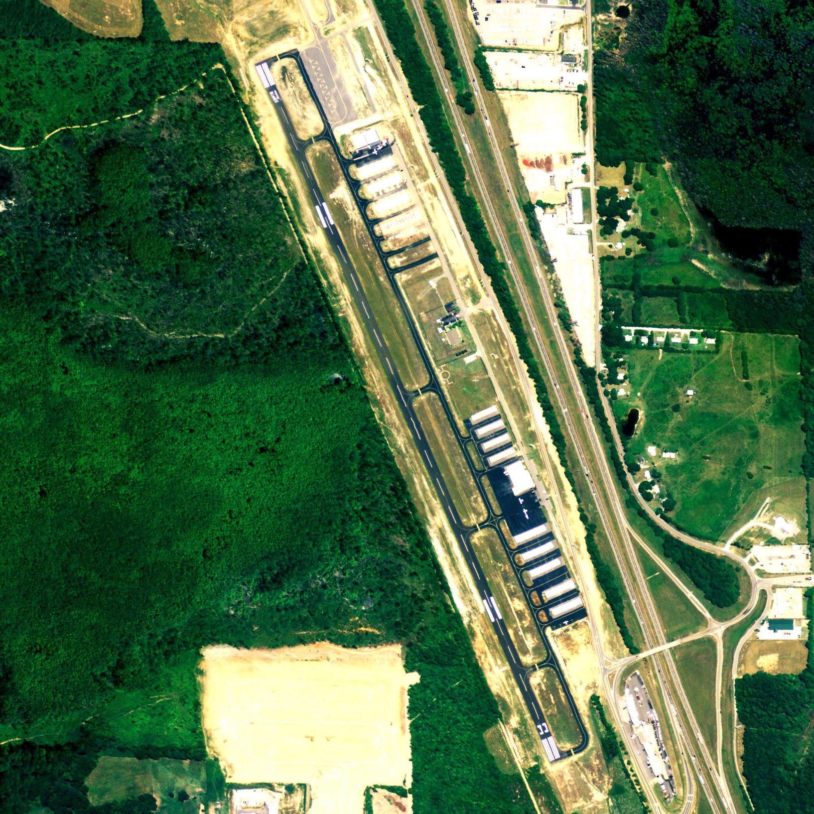
| NAIP aerial image, 2006 |
| IATA: none â ICAO: KEET â FAA LID: EET |
| Summary |
| Airport type |
Public |
| Owner |
Shelby County Commission |
| Serves |
Alabaster, Alabama |
| Location |
Calera, Alabama |
| Elevation AMSL |
586 ft / 179 m |
| Coordinates |
33°10â²40â³N 086°46â²59â³W / 33.17778°N 86.78306°W / 33.17778; -86.78306 |
| Website |
ShelbyCountyAlabama.com |
| Runways |
| Direction |
Length |
Surface |
| ft |
m |
| 16/34 |
5,000 |
1,524 |
Asphalt |
| Statistics (2010) |
| Aircraft operations |
20,848 |
| Based aircraft |
83 |
| Source: Federal Aviation Administration |
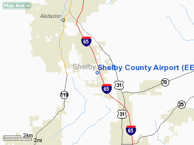
Shelby County Airport (ICAO: KEET, FAA LID: EET) is a public use airport located four nautical miles (7 km) southeast of the central business district of Alabaster, a city in Shelby County, Alabama, United States. It is owned by the Shelby County Commission. The airport is situated in the city of in Calera, Alabama.
According to the FAA's National Plan of Integrated Airport Systems for 2009â2013, it is categorized as a general aviation facility. This was a change from the 2007â2011 NPIAS Report, when it was categorized as a reliever airport.
Although most U.S. airports use the same three-letter location identifier for the FAA and IATA, this airport is assigned EET by the FAA but has no designation from the IATA. Facilities and aircraft
Shelby County Airport covers an area of 125 acres (51 ha) at an elevation of 586 feet (179 m) above mean sea level. It has one asphalt paved runway designated 16/34 which measures 5,000 by 75 feet (1,524 x 23 m). The runway runs parallel to adjacent Interstate 65. The airport has its own interchange on that highway.
For the 12-month period ending January 15, 2010, the airport had 20,848 aircraft operations, an average of 57 per day: 99% general aviation and 1% military. At that time there were 83 aircraft based at this airport: 92% single-engine, 7% multi-engine and 1% jet.
The above content comes from Wikipedia and is published under free licenses – click here to read more.
Location
& QuickFacts
|
FAA Information Effective: |
2007-01-18 |
|
Airport
Identifier: |
EET |
|
Airport
Status: |
Operational |
|
Longitude/Latitude: |
086-46-58.1750W/33-10-37.3400N
-86.782826/33.177039 (Estimated) |
|
Elevation: |
587 ft / 178.92 m (Surveyed) |
|
Land: |
125 acres |
|
From
nearest city: |
4 nautical miles SE of Alabaster, AL |
|
Location: |
Shelby County, AL |
|
Magnetic Variation: |
00E (1990) |
Owner
& Manager
|
Ownership: |
Publicly owned |
|
Owner: |
Shelby County
DEPT OF PLANNING & DEVELOPMENT |
|
Address: |
1115 Co Services Drive
Pelham, AL 35124
SHELBY CO DEPT OF PLANNING AND DEVELOPMENT |
|
Phone
number: |
205-620-6620 |
|
Manager: |
Patrick Dent |
|
Address: |
265 Weather Vane Road
Calera, AL 35040 |
|
Phone number: |
205-663-4805 |
Airport
Operations and Facilities
|
Airport Use: |
Open to public |
|
Wind
indicator: |
Yes |
|
Segmented
Circle: |
Yes |
|
Control
Tower: |
No |
|
Lighting
Schedule: |
DUSK-DAWN
ACTVT MIRL RY 15/33 AND PAPI RYS 15 & 33 - CTAF. |
|
Beacon
Color: |
Clear-Green (lighted land airport) |
|
Landing
fee charge: |
No |
|
Sectional
chart: |
Atlanta |
|
Region: |
ASO - Southern |
|
Boundary
ARTCC: |
ZTL - Atlanta |
|
Tie-in
FSS: |
ANB - Anniston |
|
FSS
on Airport: |
No |
|
FSS
Toll Free: |
1-800-WX-BRIEF |
|
NOTAMs
Facility: |
EET (NOTAM-d service avaliable) |
|
Federal Agreements: |
NGY |
Airport
Communications
|
CTAF: |
122.700 |
|
Unicom: |
122.700 |
Airport
Services
|
Fuel available: |
100LLA |
|
Airframe Repair: |
MAJOR |
|
Power Plant Repair: |
MAJOR |
|
Bottled
Oxygen: |
NONE |
|
Bulk
Oxygen: |
NONE |
|
Runway Information
Runway 15/33
|
Dimension: |
5000 x 75 ft / 1524.0 x 22.9 m |
|
Surface: |
ASPH, Good Condition |
|
Weight
Limit: |
Single wheel: 16000 lbs. |
|
Edge
Lights: |
Medium |
|
|
Runway 15 |
Runway 33 |
|
Longitude: |
086-47-10.9050W |
086-46-48.1300W |
|
Latitude: |
33-11-02.8390N |
33-10-17.2200N |
|
Elevation: |
574.00
ft |
587.00
ft |
|
Alignment: |
127 |
127 |
|
Traffic
Pattern: |
Left |
Right |
|
Markings: |
Non-precision instrument, Good Condition |
Non-precision instrument, Good Condition |
|
Crossing
Height: |
45.00
ft |
0.00 ft |
|
VASI: |
4-light PAPI on left side |
4-light PAPI on left side |
|
Visual
Glide Angle: |
3.00° |
0.00° |
|
Obstruction: |
73 ft trees, 1470.0 ft from runway, 203 ft
left of centerline, 17:1 slope to clear |
67 ft bldg, 1608.0 ft from runway, 178 ft right
of centerline, 21:1 slope to clear |
|
Radio Navigation
Aids
|
ID |
Type |
Name |
Ch |
Freq |
Var |
Dist |
|
BEQ |
NDB |
Bessemer |
|
368.00 |
00E |
10.7 nm |
|
BH |
NDB |
Mcden |
|
224.00 |
01W |
20.3 nm |
|
GGY |
NDB |
Gragg-wade |
|
338.00 |
01E |
21.3 nm |
|
SCD |
NDB |
Sylacauga |
|
284.00 |
03W |
23.4 nm |
|
PLR |
NDB |
Pell City |
|
257.00 |
01E |
35.3 nm |
|
DER |
NDB |
Alexander City |
|
382.00 |
01W |
45.1 nm |
|
TDG |
VOR/DME |
Talladega |
025X |
108.80 |
02E |
44.2 nm |
|
OKW |
VORTAC |
Brookwood |
047X |
111.00 |
00E |
23.8 nm |
|
VUZ |
VORTAC |
Vulcan |
091X |
114.40 |
02E |
30.2 nm |
|
LDK |
VORTAC |
Crimson |
125X |
117.80 |
03E |
38.2 nm |
|
BHM |
VOT |
Birmingham Muni |
|
110.00 |
|
23.3 nm |
Remarks
- COMPASS
ROSE PAINTED ON APCH END NEAR THR.
- NOISE
ABATEMENT AREA NW OF ARPT.
Based Aircraft
|
Aircraft
based on field: |
84 |
|
Single
Engine Airplanes: |
71 |
|
Multi
Engine Airplanes: |
13 |
Operational Statistics
Time Period: 2005-01-05
- 2006-01-04
|
Aircraft
Operations: |
58/Day |
|
General
Aviation Local: |
29.0% |
|
General
Aviation Itinerant: |
70.0% |
|
Military: |
1.0% |
Shelby County Airport
Address:
Shelby County, AL
Tel:
205-620-6620,
205-663-4805
Images
and information placed above are from
http://www.airport-data.com/airport/EET/
We
thank them for the data!
| General
Info |
| Country |
United
States |
| State |
ALABAMA
|
| FAA ID |
EET
|
| Latitude |
33-10-37.375N
|
| Longitude |
086-46-58.248W
|
| Elevation |
585 feet
|
| Near City |
ALABASTER
|
We don't guarantee the information is fresh and accurate. The data may
be wrong or outdated.
For more up-to-date information please refer to other sources.
|
|