 |
|
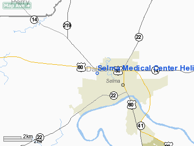
Selma Medical Center Heliport |
|
|
Location
& QuickFacts
|
FAA Information Effective: |
2007-01-18 |
|
Airport
Identifier: |
AL90 |
|
Airport
Status: |
Operational |
|
Longitude/Latitude: |
087-03-23.9660W/32-25-44.4900N
-87.056657/32.429025 (Estimated) |
|
Elevation: |
150 ft / 45.72 m (Estimated) |
|
Land: |
0
acres |
|
From
nearest city: |
1 nautical miles NW of Selma, AL |
|
Location: |
Dallas County, AL |
|
Magnetic Variation: |
01E (1985) |
Owner
& Manager
|
Ownership: |
Privately owned |
|
Owner: |
Selma Medical Cntr Hosp. Inc |
|
Address: |
1015 Medical Center Parkway
Selma, AL 36701 |
|
Phone
number: |
205-872-8461 |
|
Manager: |
Ed Stainback
CHIEF EXECUTIVE OFFICER. |
|
Address: |
1015 Medical Center Parkway
Selma, AL 36701 |
|
Phone number: |
205-872-8461 |
Airport
Operations and Facilities
|
Airport Use: |
Private
MEDICAL USE. |
|
Segmented
Circle: |
No |
|
Control
Tower: |
No |
|
Lighting
Schedule: |
PHONE REQ
FOR PERIMETER LGTS CALL 205-872-8461. |
|
Sectional
chart: |
Atlanta |
|
Region: |
ASO - Southern |
|
Boundary
ARTCC: |
ZTL - Atlanta |
|
Tie-in
FSS: |
ANB - Anniston |
|
FSS
on Airport: |
No |
|
FSS
Toll Free: |
1-800-WX-BRIEF |
|
Runway Information
Helipad H1
|
Dimension: |
50 x 50 ft / 15.2 x 15.2 m |
|
Surface: |
CONC, |
|
|
Runway H1 |
Runway |
|
Traffic
Pattern: |
Left |
Left |
|
Radio Navigation
Aids
|
ID |
Type |
Name |
Ch |
Freq |
Var |
Dist |
|
SE |
NDB |
Pollk |
|
344.00 |
01W |
11.6 nm |
|
EOG |
NDB |
Greensboro |
|
417.00 |
01E |
32.5 nm |
|
GGY |
NDB |
Gragg-wade |
|
338.00 |
01E |
34.0 nm |
|
PRN |
NDB |
Persimmon/dcmsnd |
|
359.00 |
00E |
41.4 nm |
|
RZO |
NDB |
Marengo |
|
391.00 |
01E |
48.6 nm |
|
MXF |
TACAN |
Maxwell |
097X |
|
03E |
35.1 nm |
|
JYU |
VOR/DME |
Junior |
083X |
113.60 |
01W |
6.1 nm |
|
MGM |
VORTAC |
Montgomery |
058X |
112.10 |
03E |
39.4 nm |
|
OKW |
VORTAC |
Brookwood |
047X |
111.00 |
00E |
49.7 nm |
Remarks
- PRVDD
THAT APCH/DEP OPNS CONDUCTED 150 DEG TO 170 DEG AND 220 DEG TO 235 DEG;
TKOF/LNDG APPRO. MKD,
MAINTAIN WIND INDICATOR.
Selma Medical Center Heliport
Address:
Dallas County, AL
Tel:
205-872-8461
Images
and information placed above are from
http://www.airport-data.com/airport/AL90/
We
thank them for the data!
| General
Info |
| Country |
United
States |
| State |
ALABAMA
|
| FAA ID |
AL90
|
| Latitude |
32-25-44.490N
|
| Longitude |
087-03-23.966W
|
| Elevation |
150 feet
|
| Near City |
SELMA
|
We don't guarantee the information is fresh and accurate. The data may
be wrong or outdated.
For more up-to-date information please refer to other sources.
|
|


