|
|
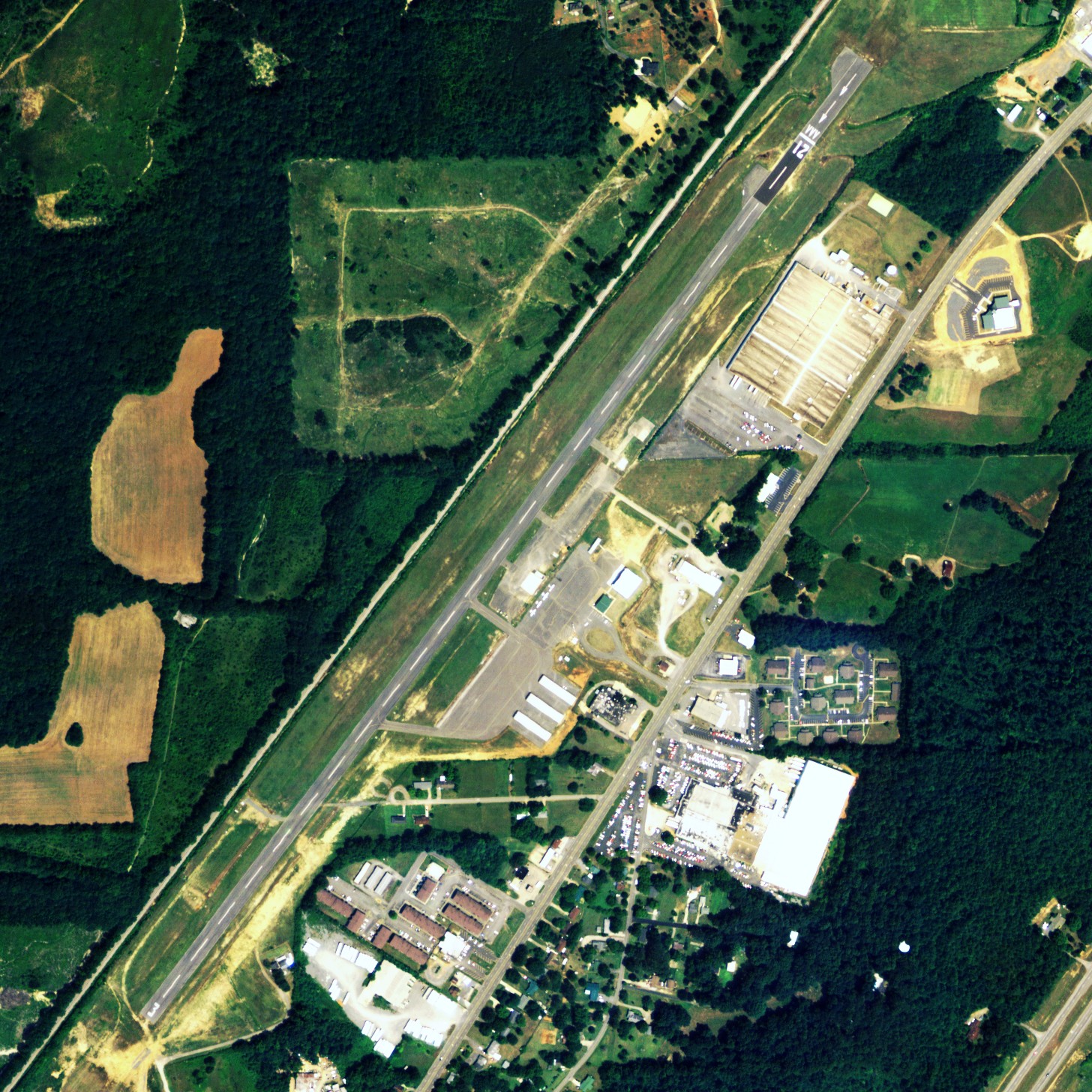
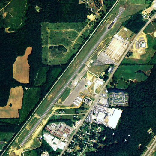
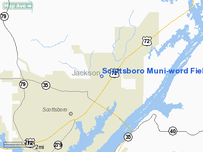
Scottsboro Municipal - Word Field Airport |
Scottsboro Municipal Airport
Word Field |
 |
| NAIP aerial image, 2006 |
| IATA: none – ICAO: none – FAA LID: 4A6 |
| Summary |
| Airport type |
Public |
| Owner |
City of Scottsboro |
| Serves |
Scottsboro, Alabama |
| Elevation AMSL |
650 ft / 198 m |
| Coordinates |
34°41′19″N 086°00′21″W / 34.68861°N 86.00583°W / 34.68861; -86.00583 |
| Website |
CityOfScottsboro.com/... |
| Runways |
| Direction |
Length |
Surface |
| ft |
m |
| 4/22 |
5,250 |
1,600 |
Asphalt |
| Statistics (2009) |
| Aircraft operations |
7,745 |
| Based aircraft |
40 |
| Source: Federal Aviation Administration |
Scottsboro Municipal Airport (FAA LID: 4A6), also known as Word Field, is a city-owned public-use airport located two nautical miles (3.7 km) northeast of the central business district of Scottsboro, a city in Jackson County, Alabama, United States. According to the FAA's National Plan of Integrated Airport Systems for 2009–2013, it is categorized as a general aviation facility.
Facilities and aircraft
Scottsboro Municipal Airport covers an area of 49 acres (20 ha) at an elevation of 650 feet (198 m) above mean sea level. It has one runway designated 4/22 with an asphalt surface measuring 5,250 by 80 feet (1,600 x 24 m).
For the 12-month period ending May 12, 2009, the airport had 7,745 aircraft operations, an average of 21 per day, all general aviation. At that time there were 40 aircraft based at this airport: 82.5% single-engine, 2.5% multi-engine and 15% ultralight.
The above content comes from Wikipedia and is published under free licenses – click here to read more.
Location
& QuickFacts
|
FAA Information Effective: |
2007-01-18 |
|
Airport
Identifier: |
4A6 |
|
Airport
Status: |
Operational |
|
Longitude/Latitude: |
086-00-21.3300W/34-41-19.3600N
-86.005925/34.688711 (Estimated) |
|
Elevation: |
650 ft / 198.12 m (Estimated) |
|
Land: |
49
acres |
|
From
nearest city: |
2 nautical miles NE of Scottsboro, AL |
|
Location: |
Jackson County, AL |
|
Magnetic Variation: |
01W (1985) |
Owner
& Manager
|
Ownership: |
Publicly owned |
|
Owner: |
City Of Scottsboro |
|
Address: |
916 Broad St
Scottsboro, AL 35768 |
|
Phone number: |
256-574-3100 |
|
Manager: |
Robert Hodges |
|
Address: |
137 Airport Road
Scottsboro, AL 35768 |
|
Phone number: |
256-259-3702 |
Airport
Operations and Facilities
|
Airport Use: |
Open to public |
|
Wind
indicator: |
Yes |
|
Segmented
Circle: |
No |
|
Control
Tower: |
No |
|
Lighting
Schedule: |
DUSK-DAWN |
|
Beacon
Color: |
Clear-Green (lighted land airport) |
|
Landing
fee charge: |
No |
|
Sectional
chart: |
Atlanta |
|
Region: |
ASO - Southern |
|
Traffic
Pattern Alt: |
800 ft |
|
Boundary
ARTCC: |
ZTL - Atlanta |
|
Tie-in
FSS: |
ANB - Anniston |
|
FSS
on Airport: |
No |
|
FSS
Toll Free: |
1-800-WX-BRIEF |
|
NOTAMs
Facility: |
ANB (NOTAM-d service avaliable) |
|
Federal Agreements: |
NGY |
Airport
Communications
|
CTAF: |
123.000 |
|
Unicom: |
123.000 |
Airport
Services
|
Fuel available: |
100LLA MOGAS |
|
Airframe Repair: |
MINOR |
|
Power Plant Repair: |
MINOR |
|
Bottled
Oxygen: |
NONE |
|
Bulk
Oxygen: |
NONE |
|
Runway Information
Runway 03/21
|
Dimension: |
5250 x 80 ft / 1600.2 x 24.4 m |
|
Surface: |
ASPH, Good Condition |
|
Weight
Limit: |
Single wheel: 15000 lbs. |
|
Edge
Lights: |
Medium |
|
|
Runway 03 |
Runway 21 |
|
Longitude: |
086-00-40.4500W |
086-00-02.2100W |
|
Latitude: |
34-40-58.7500N |
34-41-39.9700N |
|
Elevation: |
650.00
ft |
630.00
ft |
|
Traffic
Pattern: |
Right |
Left |
|
Markings: |
Basic, Good Condition |
Basic, Good Condition |
|
Displaced
threshold: |
0.00 ft |
420.00 ft
RY 21 LGTD THLDS DSPLCD FOR NIGHT OPNS. |
|
Obstruction: |
85 ft trees, 1760.0 ft from runway, 18:1 slope
to clear
RY 03 APCH SLOPE 26:1 FOR NIGHT OPNS. |
68 ft trees, 639.0 ft from runway, 67 ft left
of centerline, 9:1 slope to clear
RY 21 APCH SLOPE 15:1 FM DSPLCD THLD. |
|
Radio Navigation
Aids
|
ID |
Type |
Name |
Ch |
Freq |
Var |
Dist |
|
FTP |
NDB |
Fort Payne |
|
426.00 |
01W |
19.3 nm |
|
ARF |
NDB |
Saratoga |
|
296.00 |
02W |
28.3 nm |
|
BGF |
NDB |
Boiling Fork |
|
263.00 |
02W |
29.6 nm |
|
APT |
NDB |
Jasper |
|
382.00 |
02W |
30.5 nm |
|
UOS |
NDB |
Sewanee |
|
275.00 |
02E |
31.5 nm |
|
HUA |
NDB |
Redstone |
|
287.00 |
00W |
33.7 nm |
|
TNY |
NDB |
Kelso |
|
358.00 |
01W |
37.6 nm |
|
CWH |
NDB |
Capshaw |
|
350.00 |
01W |
38.5 nm |
|
CPP |
NDB |
Cole Spring |
|
230.00 |
01W |
44.9 nm |
|
OYD |
NDB |
Floyd |
|
388.00 |
02W |
47.8 nm |
|
ULH |
NDB |
Burwi |
|
332.00 |
03W |
47.9 nm |
|
UXM |
VOR |
Tullahoma Regional |
|
109.65 |
03W |
43.2 nm |
|
GAD |
VOR/DME |
Gadsden |
070X |
112.30 |
02E |
43.0 nm |
|
DCU |
VOR/DME |
Decatur |
075X |
112.80 |
01W |
46.2 nm |
|
RQZ |
VORTAC |
Rocket |
059X |
112.20 |
02E |
31.7 nm |
|
GQO |
VORTAC |
Choo Choo |
105X |
115.80 |
01E |
45.1 nm |
|
HSV |
VOT |
Huntsville |
|
111.00 |
|
41.7 nm |
Remarks
- RED
LGTD TV TWR 1 MILE SW.
- ADDITIONAL
OBSTNS FOR RY 03 ARE MT 2500 FT FM THLD 3000 FT LEFT & ANT 2800
FT FM THLD 4200 FT L.
- ULTRALIGHT
ACTIVITY ON & INVOF ARPT.
Based
Aircraft
|
Aircraft
based on field: |
29 |
|
Single
Engine Airplanes: |
22 |
|
Multi
Engine Airplanes: |
1 |
|
Ultralights: |
6 |
Operational Statistics
Time Period: 1998-10-02
- 1999-10-01
|
Aircraft
Operations: |
149/Week |
|
General
Aviation Local: |
18.7% |
|
General
Aviation Itinerant: |
81.3% |
Scottsboro Municipal-word Field Airport
Address:
Jackson County, AL
Tel:
256-574-3100, 256-259-3702
Images
and information placed above are from
http://www.airport-data.com/airport/4A6/
We
thank them for the data!
| General
Info |
| Country |
United
States |
| State |
ALABAMA
|
| FAA ID |
4A6
|
| Latitude |
34-41-20.302N
|
| Longitude |
086-00-20.925W
|
| Elevation |
640 feet
|
| Near City |
SCOTTSBORO
|
We don't guarantee the information is fresh and accurate. The data may
be wrong or outdated.
For more up-to-date information please refer to other sources.
|
|