 |
|
| Roy E. Ray Airport |
 |
| IATA: none – ICAO: none – FAA LID: 5R7 |
| Summary |
| Airport type |
Public use |
| Owner |
Hillery W. Grice |
| Serves |
Bayou La Batre, Alabama |
| Elevation AMSL |
80 ft / 24 m |
| Coordinates |
30°27′17″N 088°12′38″W / 30.45472°N 88.21056°W / 30.45472; -88.21056 |
| Runways |
| Direction |
Length |
Surface |
| ft |
m |
| 18/36 |
2,000 |
610 |
Turf |
| Statistics (1999) |
| Aircraft operations |
6,978 |
| Source: Federal Aviation Administration |
Roy E. Ray Airport (FAA LID: 5R7) is a privately-owned, public-use airport located 3 nautical miles (5.6 km) northeast of the central business district of Bayou La Batre, a city in Mobile County, Alabama, United States.
Facilities and aircraft
Roy E. Ray Airport covers an area of 41 acres (0.06 sq mi; 0.17 km) at an elevation of 80 feet (24 m) above mean sea level. It has one runway designated 18/36 that is 2,000 x 150 feet (610 x 46 m) with a turf surface. For the 12-month period ending November 2, 1999, the airport had 6,978 general aviation aircraft operations.
The above content comes from Wikipedia and is published under free licenses – click here to read more.
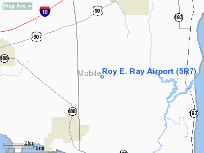
Location
& QuickFacts
|
FAA Information Effective: |
2007-01-18 |
|
Airport
Identifier: |
5R7 |
|
Airport
Status: |
Operational |
|
Longitude/Latitude: |
088-12-38.0090W/30-27-16.7090N
-88.210558/30.454641 (Estimated) |
|
Elevation: |
80
ft / 24.38 m (Estimated) |
|
Land: |
41
acres |
|
From
nearest city: |
3 nautical miles NE of Bayou La Batre, AL |
|
Location: |
Mobile County, AL |
|
Magnetic Variation: |
02E (1985) |
Owner
& Manager
|
Ownership: |
Privately owned |
|
Owner: |
Hillery W Grice
AND E L HEETER. |
|
Address: |
11317 Airport Road
Irvington, AL 36544 |
|
Phone
number: |
251-824-4538 |
|
Manager: |
H W Grice, President
ALSO E L HEETER AND R I THISTLETHWAITE. AMGR LIVES ON FIELD. |
|
Address: |
11317 Airport Road
Irvington, AL 36544 |
|
Phone number: |
251-824-4538 |
Airport
Operations and Facilities
|
Airport Use: |
Open to public |
|
Wind
indicator: |
Yes |
|
Segmented
Circle: |
No |
|
Control
Tower: |
No |
|
Lighting
Schedule: |
PHONE REQ
FOR LIRL RY 18/36 CALL 334-824-4538. |
|
Sectional
chart: |
New Orleans |
|
Region: |
ASO - Southern |
|
Boundary
ARTCC: |
ZHU - Houston |
|
Tie-in
FSS: |
ANB - Anniston |
|
FSS
on Airport: |
No |
|
FSS
Toll Free: |
1-800-WX-BRIEF |
|
NOTAMs
Facility: |
ANB (NOTAM-d service avaliable) |
Airport
Communications
Airport
Services
|
Fuel available: |
100LLMOGAS |
|
Airframe Repair: |
MINOR |
|
Power Plant Repair: |
MINOR |
|
Bottled
Oxygen: |
NONE |
|
Bulk
Oxygen: |
NONE |
|
Runway
Information
Runway 18/36
|
Dimension: |
2000 x 150 ft / 609.6 x 45.7 m |
|
Surface: |
TURF, Good Condition |
|
Edge
Lights: |
Non-standard lighting system
RY 18/36 NSTD LIRL WITH NO THLD LGTS. |
|
|
Runway 18 |
Runway 36 |
|
Traffic
Pattern: |
Left |
Left |
|
Obstruction: |
48 ft trees, 600.0 ft from runway, 153 ft left
of centerline, 12:1 slope to clear |
60 ft trees, 800.0 ft from runway, 107 ft left
of centerline, 13:1 slope to clear |
|
Radio Navigation
Aids
|
ID |
Type |
Name |
Ch |
Freq |
Var |
Dist |
|
MO |
NDB |
Wisle |
|
248.00 |
02E |
19.0 nm |
|
ESU |
NDB |
Summerdale |
|
204.00 |
01E |
25.3 nm |
|
BIX |
TACAN |
Keesler |
055X |
|
01E |
37.4 nm |
|
NPA |
TACAN |
Pensacola |
119X |
|
01E |
46.7 nm |
|
NUN |
VOR |
Saufley |
|
108.80 |
01E |
45.3 nm |
|
GPT |
VOR/DME |
Gulfport |
27X |
109.00 |
02E |
44.9 nm |
|
BFM |
VORTAC |
Brookley |
075X |
112.80 |
04E |
12.4 nm |
|
SJI |
VORTAC |
Semmes |
100X |
115.30 |
05E |
18.0 nm |
|
GCV |
VORTAC |
Greene County |
104X |
115.70 |
05E |
41.2 nm |
Remarks
- VFR
WEATHER CONDITIONS ONLY.
Based
Aircraft
|
Aircraft
based on field: |
35 |
|
Single
Engine Airplanes: |
32 |
|
Multi
Engine Airplanes: |
2 |
|
Ultralights: |
1 |
Operational Statistics
Time Period: 1998-11-03
- 1999-11-02
|
Aircraft
Operations: |
135/Week |
|
General
Aviation Local: |
41.0% |
|
General
Aviation Itinerant: |
59.0% |
Roy E. Ray Airport
Address:
Mobile County, AL
Tel:
251-824-4538
Images
and information placed above are from
http://www.airport-data.com/airport/5R7/
We
thank them for the data!
| General
Info |
| Country |
United
States |
| State |
ALABAMA
|
| FAA ID |
5R7
|
| Latitude |
30-27-16.709N
|
| Longitude |
088-12-38.009W
|
| Elevation |
80 feet
|
| Near City |
BAYOU
LA BATRE |
We don't guarantee the information is fresh and accurate. The data may
be wrong or outdated.
For more up-to-date information please refer to other sources.
|
|


