|
|
| Rountree Field |
 |
| IATA: none â ICAO: none â FAA LID: 5M0 |
| Summary |
| Airport type |
Public |
| Owner |
Hartselle, Alabama |
| Serves |
Hartselle, Alabama |
| Elevation AMSL |
628 ft / 191.4 m |
| Coordinates |
34°24â²30â³N 086°55â²59â³W / 34.40833°N 86.93306°W / 34.40833; -86.93306 |
| Runways |
| Direction |
Length |
Surface |
| ft |
m |
| 18/36 |
3,599 |
1,097 |
Asphalt |
| Statistics (2006) |
| Aircraft operations |
15,295 |
| Source: Federal Aviation Administration |
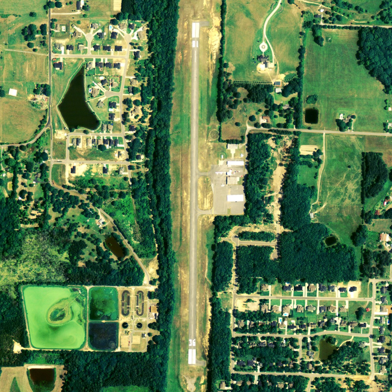
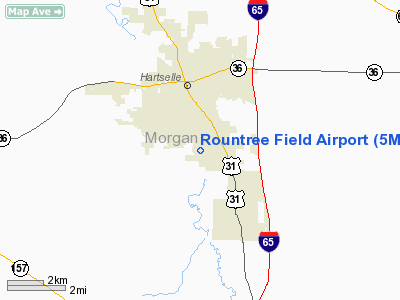
Rountree Field (FAA LID: 5M0) is a city-owned public-use airport located 2 nautical miles (4 km) south of the central business district of Hartselle, a city in Morgan County, Alabama, United States.
Facilities and aircraft
Rountree Field covers an area of 62 acres (0.10 sq mi; 0.25 km), and contains one runway designated 18/36 that is 3,599 x 75 feet (1,097 x 23 meters) with asphalt pavement. For the 12-month period ending July 12, 2006, the airport had 15,295 general aviation aircraft operations.
The above content comes from Wikipedia and is published under free licenses – click here to read more.
Location
& QuickFacts
|
FAA Information Effective: |
2007-01-18 |
|
Airport
Identifier: |
5M0 |
|
Airport
Status: |
Operational |
|
Longitude/Latitude: |
086-55-58.6220W/34-24-29.6440N
-86.932951/34.408234 (Estimated) |
|
Elevation: |
628 ft / 191.41 m (Surveyed) |
|
Land: |
62
acres |
|
From
nearest city: |
2 nautical miles S of Hartselle, AL |
|
Location: |
Morgan County, AL |
|
Magnetic Variation: |
00W (1985) |
Owner
& Manager
|
Ownership: |
Publicly owned |
|
Owner: |
City Of Hartselle |
|
Address: |
200 Sparkman St, Nw
Hartselle, AL 35640 |
|
Phone
number: |
256-773-2535 |
|
Manager: |
Stoney Powell |
|
Address: |
450 Airport Rd Sw
Hartselle, AL 35640 |
|
Phone number: |
256-773-1130
AFTER HRS PHONE 256-784-5133 OR 256-303-2777. |
Airport
Operations and Facilities
|
Airport Use: |
Open to public |
|
Wind
indicator: |
Yes |
|
Segmented
Circle: |
Yes |
|
Control
Tower: |
No |
|
Lighting
Schedule: |
DUSK-DAWN
ACTVT MIRL RY 18/36 & VASI RY 36 - CTAF. MIRL RY 18/36
PRESET HIGH INTST. |
|
Beacon
Color: |
Clear-Green (lighted land airport) |
|
Landing
fee charge: |
No |
|
Sectional
chart: |
Atlanta |
|
Region: |
ASO - Southern |
|
Boundary
ARTCC: |
ZME - Memphis |
|
Tie-in
FSS: |
ANB - Anniston |
|
FSS
on Airport: |
No |
|
FSS
Toll Free: |
1-800-WX-BRIEF |
|
NOTAMs
Facility: |
ANB (NOTAM-d service avaliable) |
|
Federal Agreements: |
NGY |
Airport
Communications
|
CTAF: |
122.800 |
|
Unicom: |
122.800 |
Airport
Services
|
Fuel available: |
100LL |
|
Airframe Repair: |
MAJOR |
|
Power Plant Repair: |
MAJOR |
|
Bottled
Oxygen: |
NONE |
|
Bulk
Oxygen: |
NONE |
|
Runway Information
Runway 18/36
|
Dimension: |
3599 x 75 ft / 1097.0 x 22.9 m |
|
Surface: |
ASPH, Fair Condition |
|
Weight
Limit: |
Single wheel: 20000 lbs. |
|
Edge
Lights: |
Medium |
|
|
Runway 18 |
Runway 36 |
|
Longitude: |
086-55-58.3540W |
086-55-58.8710W |
|
Latitude: |
34-24-47.3960N |
34-24-11.7960N |
|
Elevation: |
628.00
ft |
599.00
ft |
|
Alignment: |
127 |
1 |
|
Traffic
Pattern: |
Left |
Left |
|
Markings: |
Non-precision instrument, Good Condition |
Non-precision instrument, Good Condition |
|
Crossing
Height: |
0.00 ft |
34.00
ft |
|
VASI: |
|
2-box on left side |
|
Visual
Glide Angle: |
0.00° |
3.00° |
|
Obstruction: |
45 ft trees, 1139.0 ft from runway, 99 ft left
of centerline, 20:1 slope to clear |
95 ft trees, 1635.0 ft from runway, 104 ft
right of centerline, 15:1 slope to clear |
|
Radio Navigation
Aids
|
ID |
Type |
Name |
Ch |
Freq |
Var |
Dist |
|
CPP |
NDB |
Cole Spring |
|
230.00 |
01W |
5.9 nm |
|
HUA |
NDB |
Redstone |
|
287.00 |
00W |
21.2 nm |
|
CWH |
NDB |
Capshaw |
|
350.00 |
01W |
23.2 nm |
|
ARF |
NDB |
Saratoga |
|
296.00 |
02W |
36.4 nm |
|
GZS |
NDB |
Giles/dcmsnd |
|
375.00 |
00E |
45.1 nm |
|
TNY |
NDB |
Kelso |
|
358.00 |
01W |
47.7 nm |
|
DCU |
VOR/DME |
Decatur |
075X |
112.80 |
01W |
14.4 nm |
|
GAD |
VOR/DME |
Gadsden |
070X |
112.30 |
02E |
49.6 nm |
|
RQZ |
VORTAC |
Rocket |
059X |
112.20 |
02E |
27.7 nm |
|
MSL |
VORTAC |
Muscle Shoals |
112X |
116.50 |
01E |
33.0 nm |
|
VUZ |
VORTAC |
Vulcan |
091X |
114.40 |
02E |
44.4 nm |
|
HSV |
VOT |
Huntsville |
|
111.00 |
|
35.4 nm |
Based
Aircraft
|
Aircraft
based on field: |
31 |
|
Single
Engine Airplanes: |
29 |
|
Multi
Engine Airplanes: |
2 |
Operational Statistics
Time Period: 2005-07-13
- 2006-07-12
|
Aircraft
Operations: |
295/Week |
|
General
Aviation Local: |
28.6% |
|
General
Aviation Itinerant: |
71.4% |
Rountree Field Airport
Address:
Morgan County, AL
Tel:
256-773-2535,
256-773-1130
Images
and information placed above are from
http://www.airport-data.com/airport/5M0/
We
thank them for the data!
| General
Info |
| Country |
United
States |
| State |
ALABAMA
|
| FAA ID |
5M0
|
| Latitude |
34-24-29.644N
|
| Longitude |
086-55-58.622W
|
| Elevation |
628 feet
|
| Near City |
HARTSELLE
|
We don't guarantee the information is fresh and accurate. The data may
be wrong or outdated.
For more up-to-date information please refer to other sources.
|
|