|
|
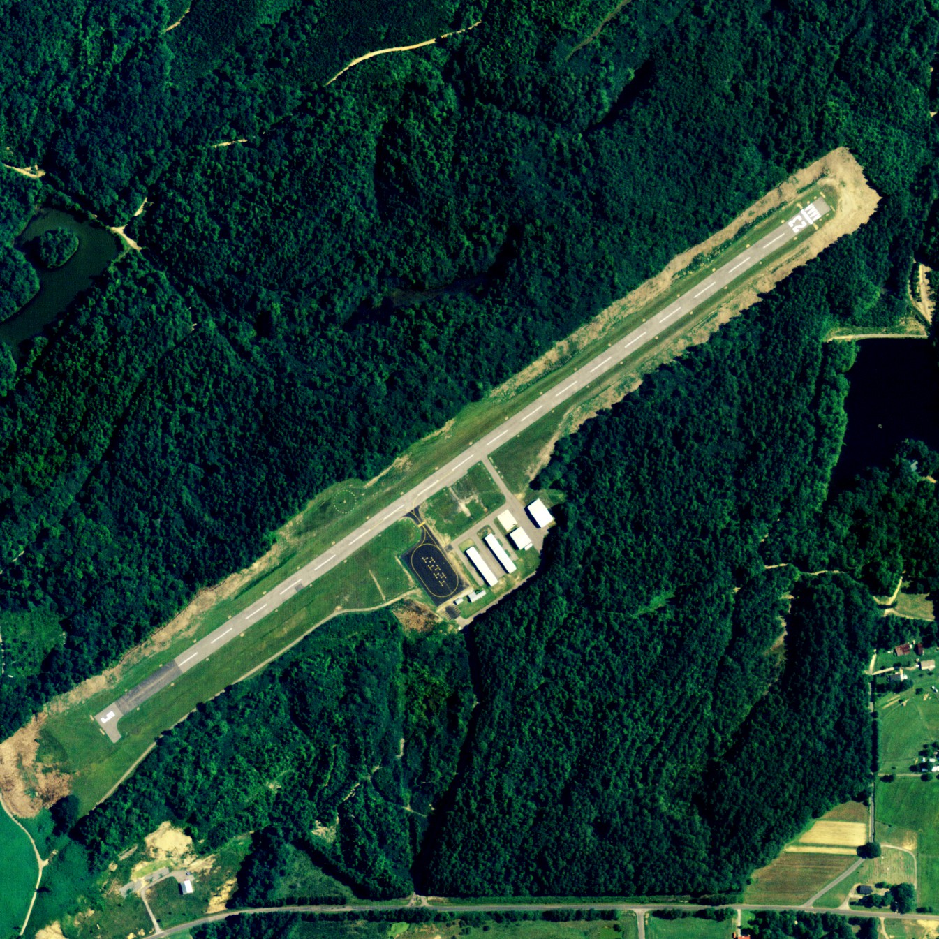
| Robbins Field |
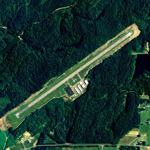 |
| NAIP aerial image, 2006 |
| IATA: none – ICAO: none – FAA LID: 20A |
| Summary |
| Airport type |
Public |
| Owner |
City of Oneonta & Blount County |
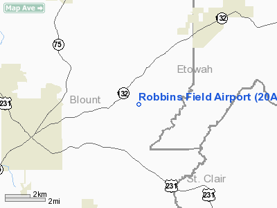
| Serves |
Oneonta, Alabama |
| Elevation AMSL |
1,140 ft / 347 m |
| Coordinates |
33°58′16″N 086°22′49″W / 33.97111°N 86.38028°W / 33.97111; -86.38028 |
| Runways |
| Direction |
Length |
Surface |
| ft |
m |
| 5/23 |
4,210 |
1,283 |
Asphalt |
| Statistics (2010) |
| Aircraft operations |
2,776 |
| Based aircraft |
17 |
| Source: Federal Aviation Administration |
Robbins Field (FAA LID: 20A) is a public use airport located five nautical miles (9 km) northeast of the central business district of Oneonta, a city in Blount County, Alabama, United States. It is owned by the City of Oneonta and Blount County. According to the FAA's National Plan of Integrated Airport Systems for 2009–2013, it is categorized as a general aviation facility.
Facilities and aircraft
Robbins Field covers an area of 43 acres (17 ha) at an elevation of 1,140 feet (347 m) above mean sea level. It has one runway designated 5/23 with an asphalt surface measuring 4,210 by 80 feet (1,283 x 24 m).
For the 12-month period ending March 23, 2010, the airport had 2,776 aircraft operations, an average of 231 per month, all general aviation. At that time there were 17 aircraft based at this airport: 88% single-engine and 12% multi-engine.
The above content comes from Wikipedia and is published under free licenses – click here to read more.
Location
& QuickFacts
|
FAA Information Effective: |
2007-01-18 |
|
Airport
Identifier: |
20A |
|
Airport
Status: |
Operational |
|
Longitude/Latitude: |
086-22-45.9380W/33-58-20.3510N
-86.379427/33.972320 (Estimated) |
|
Elevation: |
1140 ft / 347.47 m (Estimated) |
|
Land: |
43
acres |
|
From
nearest city: |
5 nautical miles NE of Oneonta, AL |
|
Location: |
Blount County, AL |
|
Magnetic Variation: |
00W (1985) |
Owner
& Manager
|
Ownership: |
Publicly owned |
|
Owner: |
City Of Oneonta & Blount Cty. |
|
Address: |
202 3rd Ave East
Oneonta, AL 35121 |
|
Phone
number: |
205-274-2150 |
|
Manager: |
Edward Lowe |
|
Address: |
202 3rd Ave East
Oneonta, AL 35121 |
|
Phone number: |
205-274-2127 |
Airport
Operations and Facilities
|
Airport Use: |
Open to public |
|
Wind
indicator: |
Yes |
|
Segmented
Circle: |
Yes |
|
Control
Tower: |
No |
|
Lighting
Schedule: |
DUSK-DAWN
ACTVT HIRL RY 05/23 - CTAF. |
|
Beacon
Color: |
Clear-Green (lighted land airport) |
|
Landing
fee charge: |
No |
|
Sectional
chart: |
Atlanta |
|
Region: |
ASO - Southern |
|
Boundary
ARTCC: |
ZTL - Atlanta |
|
Tie-in
FSS: |
ANB - Anniston |
|
FSS
on Airport: |
No |
|
FSS
Toll Free: |
1-800-WX-BRIEF |
|
NOTAMs
Facility: |
ANB (NOTAM-d service avaliable) |
|
Federal Agreements: |
NGY |
Airport
Communications
Airport
Services
|
Bottled
Oxygen: |
NONE |
|
Bulk
Oxygen: |
NONE |
|
Runway Information
Runway 05/23
|
Dimension: |
4210 x 80 ft / 1283.2 x 24.4 m |
|
Surface: |
ASPH, Fair Condition |
|
Weight
Limit: |
Single wheel: 20000 lbs.
Dual wheel: 35000 lbs.
Dual
tandem wheel: 55000 lbs. |
|
Edge
Lights: |
Medium |
|
|
Runway 05 |
Runway 23 |
|
Traffic
Pattern: |
Left |
Left |
|
Markings: |
Basic, Fair Condition |
Basic, Poor Condition
MARKINGS FADED. |
|
Displaced
threshold: |
0.00 ft |
105.00
ft |
|
Obstruction: |
77 ft trees, 1248.0 ft from runway, 91 ft left
of centerline, 13:1 slope to clear |
15 ft trees, 222.0 ft from runway, 1:1 slope
to clear
APCH RATIO 21:1 TO DSPLCD THLD. |
|
Radio Navigation
Aids
|
ID |
Type |
Name |
Ch |
Freq |
Var |
Dist |
|
ARF |
NDB |
Saratoga |
|
296.00 |
02W |
18.6 nm |
|
PLR |
NDB |
Pell City |
|
257.00 |
01E |
25.7 nm |
|
CPP |
NDB |
Cole Spring |
|
230.00 |
01W |
32.5 nm |
|
BH |
NDB |
Mcden |
|
224.00 |
01W |
36.2 nm |
|
HUA |
NDB |
Redstone |
|
287.00 |
00W |
46.3 nm |
|
SCD |
NDB |
Sylacauga |
|
284.00 |
03W |
48.1 nm |
|
BEQ |
NDB |
Bessemer |
|
368.00 |
00E |
48.1 nm |
|
FTP |
NDB |
Fort Payne |
|
426.00 |
01W |
48.2 nm |
|
GAD |
VOR/DME |
Gadsden |
070X |
112.30 |
02E |
14.8 nm |
|
TDG |
VOR/DME |
Talladega |
025X |
108.80 |
02E |
29.2 nm |
|
DCU |
VOR/DME |
Decatur |
075X |
112.80 |
01W |
49.2 nm |
|
VUZ |
VORTAC |
Vulcan |
091X |
114.40 |
02E |
31.7 nm |
|
BHM |
VOT |
Birmingham Muni |
|
110.00 |
|
30.9 nm |
Remarks
Based
Aircraft
|
Aircraft
based on field: |
18 |
|
Single
Engine Airplanes: |
18 |
Operational Statistics
Time Period: 2005-04-14
- 2006-04-13
|
Aircraft
Operations: |
54/Week |
|
General
Aviation Local: |
46.7% |
|
General
Aviation Itinerant: |
53.3% |
Robbins Field Airport
Address:
Blount County, AL
Tel:
205-274-2150,
205-274-2127
Images
and information placed above are from
http://www.airport-data.com/airport/20A/
We
thank them for the data!
| General
Info |
| Country |
United
States |
| State |
ALABAMA
|
| FAA ID |
20A
|
| Latitude |
33-58-20.351N
|
| Longitude |
086-22-45.938W
|
| Elevation |
1140 feet
|
| Near City |
ONEONTA
|
We don't guarantee the information is fresh and accurate. The data may
be wrong or outdated.
For more up-to-date information please refer to other sources.
|
|