|
|
Roanoke Municipal Airport |
| Roanoke Municipal Airport |
 |
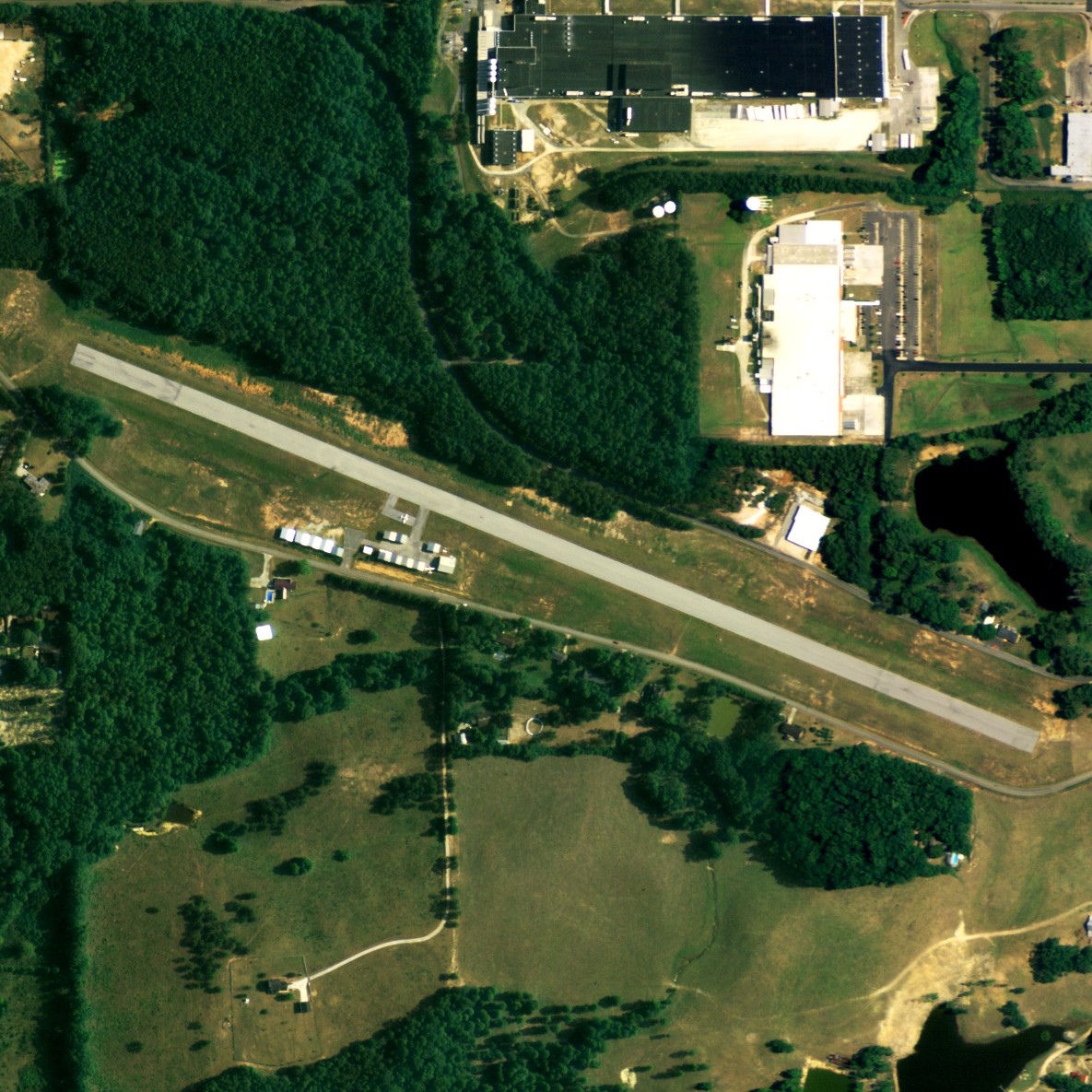
| NAIP aerial image, 2006 |
| IATA: none – ICAO: none – FAA LID: 7A5 |
| Summary |
| Airport type |
Public |
| Owner |
City of Roanoke |
| Serves |
Roanoke, Alabama |
| Elevation AMSL |
907 ft / 276 m |
| Coordinates |
33°07′47″N 085°22′20″W / 33.12972°N 85.37222°W / 33.12972; -85.37222 |
| Runways |
| Direction |
Length |
Surface |
| ft |
m |
| 11/29 |
3,697 |
1,127 |
Asphalt |
| Statistics (2009) |
| Aircraft operations |
3,116 |
| Based aircraft |
16 |
| Source: Federal Aviation Administration |
Roanoke Municipal Airport (FAA LID: 7A5) is a city-owned public-use airport located two nautical miles (3.7 km) south of the central business district of Roanoke, a city in Randolph County, Alabama, United States. According to the FAA's National Plan of Integrated Airport Systems for 2009–2013, it is categorized as a general aviation facility.
Facilities and aircraft
Roanoke Municipal Airport covers an area of 59 acres (24 ha) at an elevation of 907 feet (276 m) above mean sea level. It has one runway designated 11/29 with an asphalt surface measuring 3,697 by 80 feet (1,127 x 24 m).
For the 12-month period ending March 17, 2009, the airport had 3,116 aircraft operations, an average of 259 per month, all general aviation. At that time there were 16 aircraft based at this airport: 94% single-engine and 6% ultralight.
The above content comes from Wikipedia and is published under free licenses – click here to read more.
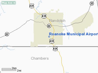
Location
& QuickFacts
|
FAA Information Effective: |
2007-01-18 |
|
Airport
Identifier: |
7A5 |
|
Airport
Status: |
Operational |
|
Longitude/Latitude: |
085-21-59.8140W/33-07-45.4340N
-85.366615/33.129287 (Estimated) |
|
Elevation: |
907 ft / 276.45 m (Estimated) |
|
Land: |
59
acres |
|
From
nearest city: |
2 nautical miles S of Roanoke, AL |
|
Location: |
Randolph County, AL |
|
Magnetic Variation: |
01W (1985) |
Owner
& Manager
|
Ownership: |
Publicly owned |
|
Owner: |
City Of Roanoke |
|
Address: |
P.o. Box 1270
Roanoke, AL 36274 |
|
Phone
number: |
334-863-4129 |
|
Manager: |
City Of Roanoke |
|
Address: |
P.o. Box 1270
Roanoke, AL 36274 |
|
Phone number: |
334-863-4129 |
Airport
Operations and Facilities
|
Airport Use: |
Open to public |
|
Wind
indicator: |
Yes |
|
Segmented
Circle: |
No |
|
Control
Tower: |
No |
|
Lighting
Schedule: |
DUSK-DAWN |
|
Beacon
Color: |
Clear-Green (lighted land airport) |
|
Landing
fee charge: |
No |
|
Sectional
chart: |
Atlanta |
|
Region: |
ASO - Southern |
|
Boundary
ARTCC: |
ZTL - Atlanta |
|
Tie-in
FSS: |
ANB - Anniston |
|
FSS
on Airport: |
No |
|
FSS
Toll Free: |
1-800-WX-BRIEF |
|
NOTAMs
Facility: |
ANB (NOTAM-d service avaliable) |
|
Federal Agreements: |
N1 |
Airport
Communications
Airport
Services
|
Airframe Repair: |
NONE |
|
Power Plant Repair: |
NONE |
|
Bottled
Oxygen: |
NONE |
|
Bulk
Oxygen: |
NONE |
|
Runway Information
Runway 11/29
|
Dimension: |
3697 x 80 ft / 1126.8 x 24.4 m |
|
Surface: |
ASPH, Good Condition |
|
Weight
Limit: |
Single wheel: 12000 lbs. |
|
Edge
Lights: |
Non-standard lighting system
NSTD LIRL; 110 VOLT GLASS JARS; RY END LIGHTS WRONG COLOR.
RY
11/29 LIRL OTS INDEFLY. |
|
|
Runway 11 |
Runway 29 |
|
Longitude: |
085-22-39.2700W |
085-21-59.2700W |
|
Latitude: |
33-07-53.6800N |
33-07-39.4700N |
|
Elevation: |
878.00
ft |
904.00
ft |
|
Traffic
Pattern: |
Left |
Left |
|
Markings: |
Basic, Good Condition |
Basic, Good Condition |
|
Displaced
threshold: |
387.00
ft |
601.00
ft |
|
Obstruction: |
44 ft trees, 468.0 ft from runway, 132 ft right
of centerline, 6:1 slope to clear
RY 11 APCH RATIO 19:1 TO DSPLCD THLD. |
38 ft pole, 311.0 ft from runway, 135 ft right
of centerline, 2:1 slope to clear
RY 29 APCH RATIO 24:1 TO DSPLCD THLD.
+15' ROAD 109' FROM THR 125' LEFT. |
|
Radio Navigation
Aids
|
ID |
Type |
Name |
Ch |
Freq |
Var |
Dist |
|
GPQ |
NDB |
Carrollton |
|
278.00 |
02W |
28.8 nm |
|
PIM |
NDB |
Pine Mountain |
|
272.00 |
03W |
30.3 nm |
|
DER |
NDB |
Alexander City |
|
382.00 |
01W |
33.5 nm |
|
EQQ |
NDB |
Coweta County |
|
234.00 |
03W |
33.8 nm |
|
FF |
NDB |
Pecat |
|
316.00 |
02W |
45.4 nm |
|
SCD |
NDB |
Sylacauga |
|
284.00 |
03W |
48.0 nm |
|
TGE |
VOR/DME |
Tuskegee |
120X |
117.30 |
02E |
41.7 nm |
|
TDG |
VOR/DME |
Talladega |
025X |
108.80 |
02E |
43.2 nm |
|
LGC |
VORTAC |
Lagrange |
103X |
115.60 |
01E |
9.4 nm |
|
CSG |
VORTAC |
Columbus |
118X |
117.10 |
01E |
35.6 nm |
Remarks
- FOR
ARPT EMERGS CALL (334) 863-2121 (POLICE).
- ARPT
OPEN FOR VFR DAY OPNS ONLY.
- PRIOR
TO ACT.
Based
Aircraft
|
Aircraft
based on field: |
12 |
|
Single
Engine Airplanes: |
11 |
|
Ultralights: |
1 |
Operational Statistics
Time Period: 1999-05-20
- 2000-05-18
|
Aircraft
Operations: |
60/Week |
|
General
Aviation Local: |
29.4% |
|
General
Aviation Itinerant: |
70.6% |
Roanoke Municipal Airport
Address:
Randolph County, AL
Tel:
334-863-4129
Images
and information placed above are from
http://www.airport-data.com/airport/7A5/
We
thank them for the data!
| General
Info |
| Country |
United
States |
| State |
ALABAMA
|
| FAA ID |
7A5
|
| Latitude |
33-07-45.434N
|
| Longitude |
085-21-59.814W
|
| Elevation |
907 feet
|
| Near City |
ROANOKE
|
We don't guarantee the information is fresh and accurate. The data may
be wrong or outdated.
For more up-to-date information please refer to other sources.
|
|