 |
|
Richard Arthur Field Airport |
| Richard Arthur Field |
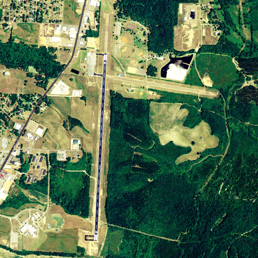 |
| NAIP aerial image, 21 June 2006 |
| IATA: none â ICAO: none â FAA LID: M95 |
| Summary |
| Airport type |
Public |
| Owner |
City of Fayette |
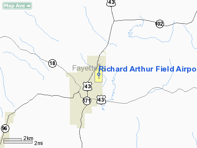
| Serves |
Fayette, Alabama |
| Elevation AMSL |
357 ft / 109 m |
| Coordinates |
33°42â²33â³N 087°48â²55â³W / 33.70917°N 87.81528°W / 33.70917; -87.81528 |
| Runways |
| Direction |
Length |
Surface |
| ft |
m |
| 18/36 |
5,008 |
1,526 |
Asphalt |
| Statistics (2006) |
| Aircraft operations |
15,300 |
| Source: Federal Aviation Administration |
Richard Arthur Field (FAA LID: M95) is a city-owned public-use airport located 3 nautical miles (6 km) northeast of the central business district of Fayette, a city in Fayette County, Alabama, United States. According to the FAA's National Plan of Integrated Airport Systems for 2009â2013, it is categorized as a general aviation facility.
Facilities and aircraft
Richard Arthur Field covers an area of 150 acres (0.23 sq mi; 0.61 km), and contains one runway designated 18/36 that is 5,008 x 80 feet (1,526 x 24 meters) with asphalt pavement. For the 12-month period ending July 27, 2006, the airport had 15,300 general aviation aircraft operations.
The above content comes from Wikipedia and is published under free licenses – click here to read more.
Location
& QuickFacts
|
FAA Information Effective: |
2007-01-18 |
|
Airport
Identifier: |
M95 |
|
Airport
Status: |
Operational |
|
Longitude/Latitude: |
087-48-54.8000W/33-42-32.8000N
-87.815222/33.709111 (Estimated) |
|
Elevation: |
357 ft / 108.81 m (Surveyed) |
|
Land: |
150 acres |
|
From
nearest city: |
3 nautical miles NE of Fayette, AL |
|
Location: |
Fayette County, AL |
|
Magnetic Variation: |
01E (1985) |
Owner
& Manager
|
Ownership: |
Publicly owned |
|
Owner: |
City Of Fayette |
|
Address: |
102 Second Ave. Se
Fayette, AL 35555 |
|
Phone
number: |
205-932-5367 |
|
Manager: |
John K. (kip) Madison |
|
Address: |
102 2nd Ave Se
Fayette, AL 35555 |
|
Phone number: |
205-932-3819
OR 205-270-6163 |
Airport
Operations and Facilities
|
Airport Use: |
Open to public |
|
Wind
indicator: |
Yes |
|
Segmented
Circle: |
No |
|
Control
Tower: |
No |
|
Lighting
Schedule: |
DUSK-DAWN
ACTVT MIRL & TWY LGTS RY 18/36; PAPI RYS 18 & 36
- CTAF. |
|
Beacon
Color: |
Clear-Green (lighted land airport) |
|
Landing
fee charge: |
No |
|
Sectional
chart: |
Atlanta |
|
Region: |
ASO - Southern |
|
Boundary
ARTCC: |
ZME - Memphis |
|
Tie-in
FSS: |
ANB - Anniston |
|
FSS
on Airport: |
No |
|
FSS
Toll Free: |
1-800-WX-BRIEF |
|
NOTAMs
Facility: |
ANB (NOTAM-d service avaliable) |
|
Federal Agreements: |
N1 |
Airport
Communications
|
CTAF: |
122.800 |
|
Unicom: |
122.800 |
Airport
Services
|
Fuel available: |
100LLA |
|
Airframe Repair: |
MAJOR |
|
Power Plant Repair: |
MAJOR |
|
Bottled
Oxygen: |
NONE |
|
Bulk
Oxygen: |
NONE |
|
Runway Information
Runway 18/36
|
Dimension: |
5008 x 80 ft / 1526.4 x 24.4 m |
|
Surface: |
ASPH, Fair Condition |
|
Weight
Limit: |
Single wheel: 15000 lbs. |
|
Edge
Lights: |
Medium |
|
|
Runway 18 |
Runway 36 |
|
Longitude: |
087-48-53.4322W |
087-48-55.5994W |
|
Latitude: |
33-42-57.3316N |
33-42-07.8216N |
|
Elevation: |
364.00
ft |
336.00
ft |
|
Alignment: |
127 |
2 |
|
Traffic
Pattern: |
Left |
Left |
|
Markings: |
Non-precision instrument, Good Condition |
Non-precision instrument, Good Condition |
|
Crossing
Height: |
45.00
ft |
45.00
ft |
|
VASI: |
2-light PAPI on left side |
2-light PAPI on left side |
|
Visual
Glide Angle: |
3.00° |
3.00° |
|
Obstruction: |
79 ft trees, 1172.0 ft from runway, 213 ft
right of centerline, 12:1 slope to clear |
56 ft trees, 1424.0 ft from runway, 45 ft left
of centerline, 21:1 slope to clear |
|
Radio Navigation
Aids
|
ID |
Type |
Name |
Ch |
Freq |
Var |
Dist |
|
FDF |
NDB |
Fayette |
|
204.00 |
00E |
0.3 nm |
|
AIV |
NDB |
Aliceville |
|
254.00 |
|
40.3 nm |
|
BH |
NDB |
Mcden |
|
224.00 |
01W |
50.0 nm |
|
LDK |
VORTAC |
Crimson |
125X |
117.80 |
03E |
30.4 nm |
|
HAB |
VORTAC |
Hamilton |
041X |
110.40 |
02E |
30.8 nm |
|
CBM |
VORTAC |
Caledonia |
099X |
115.20 |
00E |
31.4 nm |
|
IGB |
VORTAC |
Bigbee |
109X |
116.20 |
04E |
37.5 nm |
|
OKW |
VORTAC |
Brookwood |
047X |
111.00 |
00E |
40.0 nm |
|
VUZ |
VORTAC |
Vulcan |
091X |
114.40 |
02E |
45.8 nm |
Remarks
- DEER
ON & INVOF ARPT.
- PRIOR
TO FAA ACT.
Based
Aircraft
|
Aircraft
based on field: |
13 |
|
Single
Engine Airplanes: |
12 |
|
Multi
Engine Airplanes: |
1 |
Operational Statistics
Time Period: 2005-07-28
- 2006-07-27
|
Aircraft
Operations: |
295/Week |
|
General
Aviation Local: |
15.0% |
|
General
Aviation Itinerant: |
85.0% |
Richard Arthur Field Airport
Address:
Fayette County, AL
Tel:
205-932-5367,
205-932-3819
Images
and information placed above are from
http://www.airport-data.com/airport/M95/
We
thank them for the data!
| General
Info |
| Country |
United
States |
| State |
ALABAMA
|
| FAA ID |
M95
|
| Latitude |
33-42-43.991N
|
| Longitude |
087-48-54.167W
|
| Elevation |
364 feet
|
| Near City |
FAYETTE
|
We don't guarantee the information is fresh and accurate. The data may
be wrong or outdated.
For more up-to-date information please refer to other sources.
|
|


