 |
|
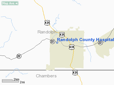
Randolph County Hospital Heliport |
Location
& QuickFacts
|
FAA Information Effective: |
2007-01-18 |
|
Airport
Identifier: |
2AL2 |
|
Airport
Status: |
Operational |
|
Longitude/Latitude: |
085-23-19.8160W/33-09-26.4310N
-85.388838/33.157342 (Estimated) |
|
Elevation: |
500 ft / 152.40 m (Estimated) |
|
Land: |
0
acres |
|
From
nearest city: |
1 nautical miles NW of Roanoke, AL |
|
Location: |
Randolph County, AL |
|
Magnetic Variation: |
01W (1990) |
Owner
& Manager
|
Ownership: |
Privately owned |
|
Owner: |
Randolph County Hospital |
|
Address: |
1000 Wadley Highway
Roanoke, AL 36274 |
|
Phone number: |
205-863-4111 |
|
Manager: |
Bobby Burroughs |
|
Address: |
1000 Wadley Highway
Roanoke, AL 36274 |
|
Phone number: |
205-863-4111 |
Airport
Operations and Facilities
|
Airport Use: |
Private
MEDICAL USE. |
|
Wind
indicator: |
Yes |
|
Segmented
Circle: |
No |
|
Control
Tower: |
No |
|
Sectional
chart: |
Atlanta |
|
Region: |
ASO - Southern |
|
Boundary
ARTCC: |
ZTL - Atlanta |
|
Tie-in
FSS: |
ANB - Anniston |
|
FSS
on Airport: |
No |
|
FSS
Toll Free: |
1-800-WX-BRIEF |
|
Runway Information
Helipad H1
|
Dimension: |
50 x 50 ft / 15.2 x 15.2 m |
|
Surface: |
CONC, |
|
|
Runway H1 |
Runway |
|
Traffic
Pattern: |
Left |
Left |
|
Radio Navigation
Aids
|
ID |
Type |
Name |
Ch |
Freq |
Var |
Dist |
|
GPQ |
NDB |
Carrollton |
|
278.00 |
02W |
27.8 nm |
|
PIM |
NDB |
Pine Mountain |
|
272.00 |
03W |
32.2 nm |
|
DER |
NDB |
Alexander City |
|
382.00 |
01W |
33.3 nm |
|
EQQ |
NDB |
Coweta County |
|
234.00 |
03W |
34.5 nm |
|
FF |
NDB |
Pecat |
|
316.00 |
02W |
46.2 nm |
|
SCD |
NDB |
Sylacauga |
|
284.00 |
03W |
46.8 nm |
|
PLR |
NDB |
Pell City |
|
257.00 |
01E |
49.5 nm |
|
TDG |
VOR/DME |
Talladega |
025X |
108.80 |
02E |
41.3 nm |
|
TGE |
VOR/DME |
Tuskegee |
120X |
117.30 |
02E |
42.8 nm |
|
LGC |
VORTAC |
Lagrange |
103X |
115.60 |
01E |
11.3 nm |
|
CSG |
VORTAC |
Columbus |
118X |
117.10 |
01E |
37.6 nm |
Remarks
- PRIVATE
USE, AREA IS MKD, WIND INDICATOR MNTND; OPS CONDUCTED FROM 180 DEGREES
TO 210 DEGREES AND FROM 260 DEGREES TO 290 DEGREES.
Randolph County Hospital Heliport
Address:
Randolph County, AL
Tel:
205-863-4111
Images
and information placed above are from
http://www.airport-data.com/airport/2AL2/
We
thank them for the data!
| General
Info |
| Country |
United
States |
| State |
ALABAMA
|
| FAA ID |
2AL2
|
| Latitude |
33-09-26.431N
|
| Longitude |
085-23-19.816W
|
| Elevation |
500 feet
|
| Near City |
ROANOKE
|
We don't guarantee the information is fresh and accurate. The data may
be wrong or outdated.
For more up-to-date information please refer to other sources.
|
|


