 |
|
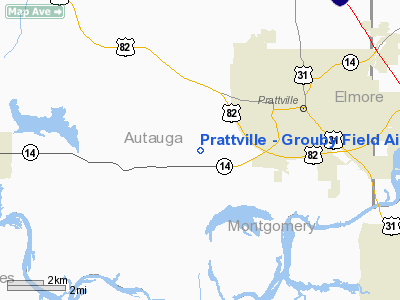
Prattville - Grouby Field Airport |
| Prattville-Grouby Field |
 |
| NAIP aerial image, 2006 |
| IATA: none â ICAO: none â FAA LID: 1A9 |
| Summary |
| Airport type |
Public |
| Owner |
Prattville Airport Authority |
| Serves |
Prattville, Alabama |
| Elevation AMSL |
225 ft / 69 m |
| Coordinates |
32°26â²19â³N 086°30â²46â³W / 32.43861°N 86.51278°W / 32.43861; -86.51278 |
| Website |
PrattvilleAirport.8k.com |
| Runways |
| Direction |
Length |
Surface |
| ft |
m |
| 9/27 |
5,400 |
1,646 |
Asphalt |
| Statistics (2007) |
| Aircraft operations |
8,754 |
| Based aircraft |
38 |
| Source: Federal Aviation Administration |
Prattville-Grouby Field (FAA LID: 1A9) is a public use airport located three nautical miles (6 km) southwest of the central business district of Prattville, a city in Autauga County, Alabama, United States. It is owned by the Pratville Airport Authority. It is also known as Prattville Airport or Autauga County Airport.
Facilities and aircraft
Prattville - Grouby Field covers an area of 82 acres (33 ha) at an elevation of 225 feet (69 m) above mean sea level. It has one runway designated 9/27 with an asphalt surface measuring 5,400 by 100 feet (1,646 x 30 m).
For the 12-month period ending October 1, 2007, the airport had 8,754 aircraft operations, an average of 23 per day: 97% general aviation and 3% military. At that time there were 38 aircraft based at this airport: 87% single-engine and 13% multi-engine.
The above content comes from Wikipedia and is published under free licenses – click here to read more.
Location
& QuickFacts
|
FAA Information Effective: |
2007-01-18 |
|
Airport
Identifier: |
1A9 |
|
Airport
Status: |
Operational |
|
Longitude/Latitude: |
086-30-45.6600W/32-26-19.4500N
-86.512683/32.438736 (Estimated) |
|
Elevation: |
225 ft / 68.58 m (Estimated) |
|
Land: |
82
acres |
|
From
nearest city: |
3 nautical miles SW of Prattville, AL |
|
Location: |
Autauga County, AL |
|
Magnetic Variation: |
00W (1985) |
Owner
& Manager
|
Ownership: |
Publicly owned |
|
Owner: |
Pratville Arpt Auth.
LARRY PUCKETT, CHAIRMAN. |
|
Address: |
143 Grouby Airport Rd
Prattville, AL 36067 |
|
Phone
number: |
334-361-0060 |
|
Manager: |
Larry Puckett |
|
Address: |
143 Grouby Airport Rd
Prattville, AL 36067 |
|
Phone
number: |
334-361-0060
AFTER HOURS PHONE 334-365-8885; SVC CHARGE. |
Airport
Operations and Facilities
|
Airport Use: |
Open to public |
|
Wind
indicator: |
Yes |
|
Segmented
Circle: |
Yes |
|
Control
Tower: |
No |
|
Lighting
Schedule: |
DUSK-DAWN
ACTVT MIRL RY 09/27 - CTAF. |
|
Beacon
Color: |
Clear-Green (lighted land airport) |
|
Landing
fee charge: |
No |
|
Sectional
chart: |
Atlanta |
|
Region: |
ASO - Southern |
|
Traffic
Pattern Alt: |
785 ft |
|
Boundary
ARTCC: |
ZTL - Atlanta |
|
Tie-in
FSS: |
ANB - Anniston |
|
FSS
on Airport: |
No |
|
FSS
Toll Free: |
1-800-WX-BRIEF |
|
NOTAMs
Facility: |
ANB (NOTAM-d service avaliable) |
|
Federal Agreements: |
NGY |
Airport
Communications
|
CTAF: |
122.800 |
|
Unicom: |
122.800 |
Airport
Services
|
Fuel available: |
100LLA |
|
Airframe Repair: |
MAJOR |
|
Power Plant Repair: |
MAJOR |
|
Bottled
Oxygen: |
NONE |
|
Runway Information
Runway 09/27
|
Dimension: |
5400 x 100 ft / 1645.9 x 30.5 m |
|
Surface: |
ASPH, Good Condition |
|
Weight
Limit: |
Single wheel: 30000 lbs. |
|
Edge
Lights: |
Medium |
|
|
Runway 09 |
Runway 27 |
|
Longitude: |
086-31-17.1500W |
086-30-14.1500W |
|
Latitude: |
32-26-19.0900N |
32-26-19.8300N |
|
Elevation: |
223.00
ft |
198.00
ft |
|
Alignment: |
89 |
127 |
|
Traffic
Pattern: |
Left |
Left |
|
Markings: |
Non-precision instrument, Good Condition |
Non-precision instrument, Good Condition |
|
Crossing
Height: |
26.00
ft |
32.00
ft |
|
VASI: |
4-light PAPI on left side
RY 9 PAPI OTS INDEFLY. |
4-light PAPI on left side |
|
Visual
Glide Angle: |
3.00° |
3.00° |
|
Obstruction: |
90 ft trees, 1494.0 ft from runway, 214 ft
left of centerline, 14:1 slope to clear |
74 ft trees, 1718.0 ft from runway, 120 ft
right of centerline, 20:1 slope to clear |
|
Radio Navigation
Aids
|
ID |
Type |
Name |
Ch |
Freq |
Var |
Dist |
|
SE |
NDB |
Pollk |
|
344.00 |
01W |
23.4 nm |
|
GGY |
NDB |
Gragg-wade |
|
338.00 |
01E |
25.4 nm |
|
PRN |
NDB |
Persimmon/dcmsnd |
|
359.00 |
00E |
35.7 nm |
|
DER |
NDB |
Alexander City |
|
382.00 |
01W |
38.5 nm |
|
TO |
NDB |
Blood |
|
365.00 |
01W |
42.0 nm |
|
SCD |
NDB |
Sylacauga |
|
284.00 |
03W |
45.3 nm |
|
MXF |
TACAN |
Maxwell |
097X |
|
03E |
8.1 nm |
|
JYU |
VOR/DME |
Junior |
083X |
113.60 |
01W |
24.9 nm |
|
TGE |
VOR/DME |
Tuskegee |
120X |
117.30 |
02E |
42.9 nm |
|
MGM |
VORTAC |
Montgomery |
058X |
112.10 |
03E |
16.3 nm |
Based
Aircraft
|
Aircraft
based on field: |
36 |
|
Single
Engine Airplanes: |
30 |
|
Multi
Engine Airplanes: |
6 |
Operational Statistics
Time Period: 2005-09-19
- 2006-09-18
|
Aircraft
Operations: |
169/Week |
|
General
Aviation Local: |
30.4% |
|
General
Aviation Itinerant: |
66.7% |
|
Military: |
2.9% |
Prattville - Grouby Field Airport
Address:
Autauga County, AL
Tel:
334-361-0060
Images
and information placed above are from
http://www.airport-data.com/airport/1A9/
We
thank them for the data!
| General
Info |
| Country |
United
States |
| State |
ALABAMA
|
| FAA ID |
1A9
|
| Latitude |
32.438736
32° 26' 19.45" N |
| Longitude |
-86.512683
086° 30' 45.66" W |
| Elevation |
225 feet
69 meters |
| Type |
Civil
|
| Magnetic
Variation |
002° W
(01/06) |
| Beacon |
Yes
|
| Operating
Agency |
U.S.CIVIL
AIRPORT WHEREIN PERMIT COVERS USE BY TRANSIT MILITARY AIRCRAFT
|
| Daylight
Saving Time |
Second
Sunday in March at 0200 to first Sunday in November at 0200 local
time (Exception Arizona and that portion of Indiana in the Eastern
Time Zone) |
We don't guarantee the information is fresh and accurate. The data may
be wrong or outdated.
For more up-to-date information please refer to other sources.
|
|


