 |
|
| Posey Field |
 |
| IATA: none – ICAO: none – FAA LID: 1M4 |
| Summary |
| Airport type |
Public |
| Owner |
Haleyville, Alabama |
| Serves |
Haleyville, Alabama |
| Elevation AMSL |
930 ft / 283.5 m |
| Coordinates |
34°16′49″N 087°36′02″W / 34.28028°N 87.60056°W / 34.28028; -87.60056 |
| Runways |
| Direction |
Length |
Surface |
| ft |
m |
| 18/36 |
5,008 |
1,526 |
Asphalt |
| Statistics (2006) |
| Aircraft operations |
10,185 |
| Source: Federal Aviation Administration |
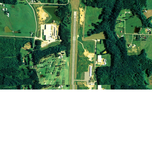
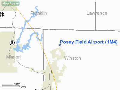
Posey Field (FAA LID: 1M4) is a city-owned public-use airport located 3 nautical miles (6 km) northeast of the central business district of Haleyville, a city in Winston County, Alabama, United States.
Facilities and aircraft
Posey Field covers an area of 120 acres (0.19 sq mi; 0.49 km), and contains one runway designated 18/36 that is 5,008 x 100 feet (1,526 x 30 meters) with asphalt pavement. For the 12-month period ending June 14, 2006, the airport had 10,185 general aviation aircraft operations.
The above content comes from Wikipedia and is published under free licenses – click here to read more.
Location
& QuickFacts
|
FAA Information Effective: |
2007-01-18 |
|
Airport
Identifier: |
1M4 |
|
Airport
Status: |
Operational |
|
Longitude/Latitude: |
087-36-01.5890W/34-16-49.2530N
-87.600441/34.280348 (Estimated) |
|
Elevation: |
930 ft / 283.46 m (Surveyed) |
|
Land: |
120 acres |
|
From
nearest city: |
3 nautical miles NE of Haleyville, AL |
|
Location: |
Winston County, AL |
|
Magnetic Variation: |
01W (2000) |
Owner
& Manager
|
Ownership: |
Publicly owned |
|
Owner: |
City Of Haleyville |
|
Address: |
City Hall, 20th Street
Haleyville, AL 35565 |
|
Phone number: |
205-486-3121 |
|
Manager: |
Mike Bailey |
|
Address: |
Rt 1 - Box 910
Haleyville, AL 35565 |
|
Phone number: |
205-486-8054
PAY PHONE 205-486-4067 |
Airport
Operations and Facilities
|
Airport Use: |
Open to public |
|
Wind
indicator: |
Yes |
|
Segmented
Circle: |
Yes |
|
Control
Tower: |
No |
|
Lighting
Schedule: |
DUSK-DAWN
ACTVT MIRL RY 18/36 - CTAF. |
|
Beacon
Color: |
Clear-Green (lighted land airport) |
|
Landing
fee charge: |
No |
|
Sectional
chart: |
Atlanta |
|
Region: |
ASO - Southern |
|
Boundary
ARTCC: |
ZME - Memphis |
|
Tie-in
FSS: |
ANB - Anniston |
|
FSS
on Airport: |
No |
|
FSS
Toll Free: |
1-800-WX-BRIEF |
|
NOTAMs
Facility: |
ANB (NOTAM-d service avaliable) |
|
Federal Agreements: |
NGY |
Airport
Communications
|
CTAF: |
122.800 |
|
Unicom: |
122.800 |
Airport
Services
|
Fuel available: |
100LLA |
|
Airframe Repair: |
MAJOR |
|
Power Plant Repair: |
MAJOR |
|
Bottled
Oxygen: |
NONE |
|
Bulk
Oxygen: |
NONE |
|
Runway Information
Runway 18/36
|
Dimension: |
5008 x 100 ft / 1526.4 x 30.5 m |
|
Surface: |
ASPH, Fair Condition |
|
Weight
Limit: |
Single wheel: 20000 lbs. |
|
Edge
Lights: |
Medium |
|
|
Runway 18 |
Runway 36 |
|
Longitude: |
087-36-00.6200W |
087-36-02.3700W |
|
Latitude: |
34-17-13.9600N |
34-16-24.4400N |
|
Elevation: |
930.00
ft |
902.00
ft |
|
Alignment: |
127 |
2 |
|
Traffic
Pattern: |
Left |
Left |
|
Markings: |
Non-precision instrument, Poor Condition
/36 MARKINGS FADED. |
Non-precision instrument, Poor Condition |
|
Runway
End Identifier: |
Yes |
No |
|
Obstruction: |
109 ft tree, 929.0 ft from runway, 87 ft right
of centerline, 6:1 slope to clear |
24 ft trees, 261.0 ft from runway, 128 ft right
of centerline, 2:1 slope to clear |
|
Radio Navigation
Aids
|
ID |
Type |
Name |
Ch |
Freq |
Var |
Dist |
|
FDF |
NDB |
Fayette |
|
204.00 |
00E |
35.6 nm |
|
CPP |
NDB |
Cole Spring |
|
230.00 |
01W |
38.9 nm |
|
DCU |
VOR/DME |
Decatur |
075X |
112.80 |
01W |
39.5 nm |
|
HAB |
VORTAC |
Hamilton |
041X |
110.40 |
02E |
21.1 nm |
|
MSL |
VORTAC |
Muscle Shoals |
112X |
116.50 |
01E |
26.2 nm |
Remarks
- UNRESTRICTED
GOLF CART ACCESS.
- PRIOR
TO FAA ACT.
Based
Aircraft
|
Aircraft
based on field: |
14 |
|
Single
Engine Airplanes: |
10 |
|
Multi
Engine Airplanes: |
3 |
|
Jet Engine
Airplanes: |
1 |
Operational Statistics
Time Period: 2005-06-15
- 2006-06-14
|
Aircraft
Operations: |
196/Week |
|
General
Aviation Local: |
16.9% |
|
General
Aviation Itinerant: |
83.1% |
Posey Field Airport
Address:
Winston County, AL
Tel:
205-486-3121, 205-486-8054
Images
and information placed above are from
http://www.airport-data.com/airport/1M4/
We
thank them for the data!
| General
Info |
| Country |
United
States |
| State |
ALABAMA
|
| FAA ID |
1M4
|
| Latitude |
34-16-49.253N
|
| Longitude |
087-36-01.589W
|
| Elevation |
930 feet
|
| Near City |
HALEYVILLE
|
We don't guarantee the information is fresh and accurate. The data may
be wrong or outdated.
For more up-to-date information please refer to other sources.
|
|


