|
|
Northeast Alabama Regional Airport |
| Northeast Alabama Regional Airport |
 |
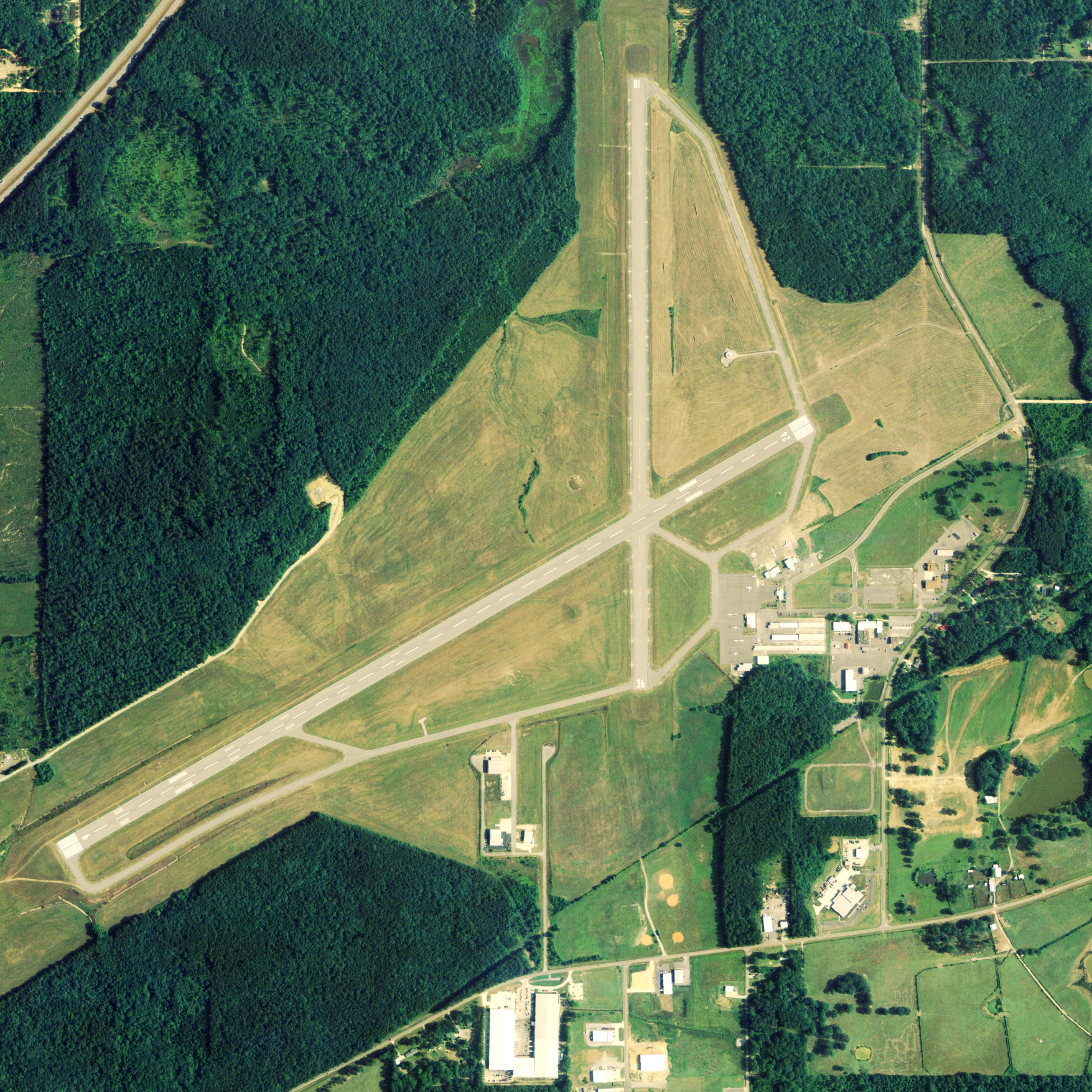
| NAIP aerial image, 2006 |
| IATA: GAD â ICAO: KGAD â FAA LID: GAD |
| Summary |
| Airport type |
Public |
| Owner |
Gadsden Airport Authority |
| Serves |
Gadsden, Alabama |
| Elevation AMSL |
569 ft / 173 m |
| Coordinates |
33°58â²22â³N 086°05â²21â³W / 33.97278°N 86.08917°W / 33.97278; -86.08917 |
| Runways |
| Direction |
Length |
Surface |
| ft |
m |
| 6/24 |
6,802 |
2,073 |
Asphalt |
| 18/36 |
4,806 |
1,465 |
Asphalt |
| Statistics (2009) |
| Aircraft operations |
23,886 |
| Based aircraft |
95 |
| Source: Federal Aviation Administration |
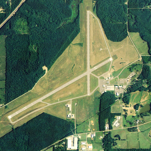
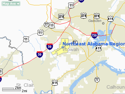
Northeast Alabama Regional Airport (IATA: GAD, ICAO: KGAD, FAA LID: GAD) is a public use airport located four nautical miles (7 km) southwest of the central business district of Gadsden, a city in Etowah County, Alabama, United States. It is owned by Gadsden Airport Authority and it was previously known as Gadsden Municipal Airport. According to the FAA's National Plan of Integrated Airport Systems for 2009â2013, it is categorized as a general aviation facility. The airport formerly had scheduled passenger service. Facilities and aircraft
Northeast Alabama Regional Airport covers an area of 1,480 acres (599 ha) at an elevation of 569 feet (173 m) above mean sea level. It has two asphalt paved runways: 6/24 is 6,802 by 150 feet (2,073 x 46 m) and 18/36 is 4,806 by 150 feet (1,465 x 46 m).
For the 12-month period ending April 9, 2009, the airport had 23,886 aircraft operations, an average of 65 per day: 93% general aviation, 5% air taxi and 2% military. At that time there were 95 aircraft based at this airport: 89% single-engine, 4% multi-engine, 3% jet, 2% glider and 1% helicopter.
Former airlines
- Air New Orleans - mid-1980s
- Atlantic Southeast Airlines - early 1990s
Incidents and accidents
- On April 9, 1990, a Delta Connection flight operated by Atlantic Southeast Airlines Embraer EMB-120 (Registration N217AS) as Flight 2254, in route to William B. Hartsfield Atlanta International Airport struck a Cessna 172 mid air just after take-off. The Embraer was able to successfully land the aircraft; however, the Cessna was unable to regain control and crashed to the ground. Of the 7 occupants onboard the Embraer, there were zero fatalities; of the 2 occupants onboard the Cessna, there were two fatalities. The cause of the crash was attributed to pilots of both aircraft inadequately performing a visual lookout in addition to restricted vision caused by the sun's glare.
The above content comes from Wikipedia and is published under free licenses – click here to read more.
Location
& QuickFacts
|
FAA Information Effective: |
2007-01-18 |
|
Airport
Identifier: |
GAD |
|
Airport
Status: |
Operational |
|
Longitude/Latitude: |
086-05-20.4050W/33-58-21.4510N
-86.089001/33.972625 (Estimated) |
|
Elevation: |
569 ft / 173.43 m (Surveyed) |
|
Land: |
1480 acres |
|
From
nearest city: |
4 nautical miles SW of Gadsden, AL |
|
Location: |
Etowah County, AL |
|
Magnetic Variation: |
00E (1980) |
Owner
& Manager
|
Ownership: |
Publicly owned |
|
Owner: |
City Of Gadsden |
|
Address: |
Po Box 267
Gadsden, AL 35999 |
|
Phone
number: |
256-549-4516 |
|
Manager: |
Fred Sington, Jr. |
|
Address: |
Gadsden Municipal Airport, Po Box 267
Gadsden, AL 35902-0267 |
|
Phone
number: |
256-549-4530
ADDNL PHONE 256-442-3313 FOR INTL JETS FBO. |
Airport
Operations and Facilities
|
Airport Use: |
Open to public |
|
Wind
indicator: |
Yes |
|
Segmented
Circle: |
Yes |
|
Control
Tower: |
No |
|
Lighting
Schedule: |
DUSK-DAWN
ACTVT HIRL RY 06/24, PAPI RY 18/36, VASI RY 06/24; REILS
RYS 06, 24, 18 &36 AND TWY LGTS - CTAF. |
|
Beacon
Color: |
Clear-Green (lighted land airport) |
|
Landing
fee charge: |
No |
|
Sectional
chart: |
Atlanta |
|
Region: |
ASO - Southern |
|
Boundary
ARTCC: |
ZTL - Atlanta |
|
Tie-in
FSS: |
ANB - Anniston |
|
FSS
on Airport: |
No |
|
FSS
Toll Free: |
1-800-WX-BRIEF |
|
NOTAMs
Facility: |
GAD (NOTAM-d service avaliable) |
|
Federal Agreements: |
NGPRY3 |
Airport
Communications
|
CTAF: |
122.800 |
|
Unicom: |
122.800 |
Airport
Services
|
Fuel available: |
100LLA
SERVICE CHARGE FOR FUEL DARK-DAWN. |
|
Airframe Repair: |
MAJOR |
|
Power Plant Repair: |
MAJOR |
|
Runway Information
Runway 06/24
|
Dimension: |
6802 x 150 ft / 2073.2 x 45.7 m |
|
Surface: |
ASPH, Good Condition |
|
Surface
Treatment: |
Saw-cut or plastic Grooved |
|
Weight
Limit: |
Single wheel: 90000 lbs.
Dual wheel: 115000 lbs.
Dual
tandem wheel: 195000 lbs. |
|
Edge
Lights: |
High |
|
|
Runway 06 |
Runway 24 |
|
Longitude: |
086-06-03.8744W |
086-04-53.4004W |
|
Latitude: |
33-57-57.0188N |
33-58-29.8968N |
|
Elevation: |
569.00
ft |
549.00
ft |
|
Alignment: |
61 |
127 |
|
Traffic
Pattern: |
Left |
Left |
|
Markings: |
Precision instrument, Good Condition |
Non-precision instrument, Good Condition |
|
VASI: |
4-box on left side |
4-box on left side |
|
Runway
End Identifier: |
Yes |
Yes
RY 24 REIL OTS INDEFLY. |
|
Runway 18/36
|
Dimension: |
4806 x 150 ft / 1464.9 x 45.7 m |
|
Surface: |
ASPH, Good Condition |
|
Weight
Limit: |
Single wheel: 25000 lbs.
Dual wheel: 40000 lbs.
Dual
tandem wheel: 78000 lbs. |
|
|
Runway 18 |
Runway 36 |
|
Longitude: |
086-05-09.3400W |
086-05-09.5939W |
|
Latitude: |
33-58-56.7370N |
33-58-09.2008N |
|
Elevation: |
542.00
ft |
553.00
ft |
|
Alignment: |
127 |
0 |
|
Traffic
Pattern: |
Left |
Left |
|
Markings: |
Basic, Good Condition |
Basic, Good Condition |
|
Crossing
Height: |
42.00
ft |
40.00
ft |
|
VASI: |
2-light PAPI on left side |
2-light PAPI on left side |
|
Visual
Glide Angle: |
2.75° |
2.75° |
|
Runway
End Identifier: |
Yes |
Yes |
|
Radio Navigation
Aids
|
ID |
Type |
Name |
Ch |
Freq |
Var |
Dist |
|
ARF |
NDB |
Saratoga |
|
296.00 |
02W |
18.1 nm |
|
PLR |
NDB |
Pell City |
|
257.00 |
01E |
26.1 nm |
|
FTP |
NDB |
Fort Payne |
|
426.00 |
01W |
38.9 nm |
|
CPP |
NDB |
Cole Spring |
|
230.00 |
01W |
43.6 nm |
|
BH |
NDB |
Mcden |
|
224.00 |
01W |
46.9 nm |
|
SCD |
NDB |
Sylacauga |
|
284.00 |
03W |
49.3 nm |
|
GAD |
VOR/DME |
Gadsden |
070X |
112.30 |
02E |
0.4 nm |
|
TDG |
VOR/DME |
Talladega |
025X |
108.80 |
02E |
24.0 nm |
|
VUZ |
VORTAC |
Vulcan |
091X |
114.40 |
02E |
44.4 nm |
|
RMG |
VORTAC |
Rome |
101X |
115.40 |
01E |
49.6 nm |
|
BHM |
VOT |
Birmingham Muni |
|
110.00 |
|
41.4 nm |
Remarks
Based
Aircraft
|
Aircraft
based on field: |
49 |
|
Single
Engine Airplanes: |
37 |
|
Multi
Engine Airplanes: |
8 |
|
Jet Engine
Airplanes: |
1 |
|
Helicopters: |
1 |
|
Gliders: |
2 |
Operational Statistics
Time Period: 2005-04-13
- 2006-04-12
|
Aircraft
Operations: |
66/Day |
|
Air Taxi: |
5.0% |
|
General
Aviation Local: |
19.8% |
|
General
Aviation Itinerant: |
73.3% |
|
Military: |
1.8% |
Northeast Alabama Regional Airport
Address:
Etowah County, AL
Tel:
256-549-4516,
256-549-4530
Images
and information placed above are from
http://www.airport-data.com/airport/GAD/
We
thank them for the data!
| General
Info |
| Country |
United
States |
| State |
ALABAMA
|
| FAA ID |
GAD
|
| Time |
UTC-6(-5DT)
|
| Latitude |
33.972625
33° 58' 21.45" N |
| Longitude |
-86.089003
086° 05' 20.41" W |
| Elevation |
569 feet
173 meters |
| Type |
Civil
|
| Magnetic
Variation |
003° W
(07/06) |
| Beacon |
Yes
|
| Operating
Agency |
U.S.CIVIL
AIRPORT WHEREIN PERMIT COVERS USE BY TRANSIT MILITARY AIRCRAFT
|
| Operating
Hours |
SEE REMARKS
FOR OPERATING HOURS OR COMMUNICATIONS FOR POSSIBLE HOURS |
| Daylight
Saving Time |
Second
Sunday in March at 0200 to first Sunday in November at 0200 local
time (Exception Arizona and that portion of Indiana in the Eastern
Time Zone) |
We don't guarantee the information is fresh and accurate. The data may
be wrong or outdated.
For more up-to-date information please refer to other sources.
|
|