 |
|
| North Pickens Airport |
 |
| IATA: none â ICAO: none â FAA LID: 3M8 |
| Summary |
| Airport type |
Public |
| Owner |
Pickens County Commission |
| Serves |
Reform, Alabama |
| Elevation AMSL |
237 ft / 72 m |
| Coordinates |
33°23â²12â³N 088°00â²24â³W / 33.38667°N 88.00667°W / 33.38667; -88.00667 |
| Runways |
| Direction |
Length |
Surface |
| ft |
m |
| 1/19 |
5,144 |
1,568 |
Asphalt |
| Statistics (2006) |
| Aircraft operations |
3,466 |
| Source: Federal Aviation Administration |
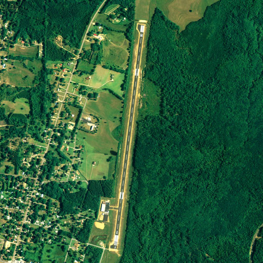
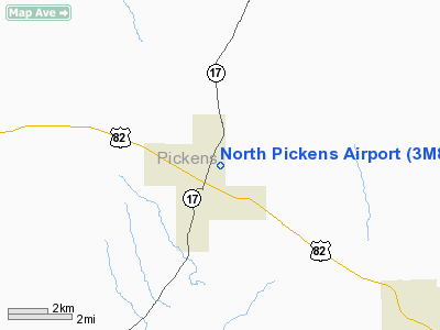
North Pickens Airport (FAA LID: 3M8) is a county-owned public-use airport located 1 mile (1.6 km) north of the central business district of Reform, a city in Pickens County, Alabama, United States.
Facilities and aircraft
North Pickens Airport covers an area of 64 acres (0.100 sq mi; 0.259 km), and contains one runway designated 1/19 that is 5,144 x 80 feet (1,568 x 24 meters) with asphalt pavement. For the 12-month period ending October 31, 2006, the airport had 3,466 general aviation aircraft operations.
The above content comes from Wikipedia and is published under free licenses – click here to read more.
Location
& QuickFacts
|
FAA Information Effective: |
2007-01-18 |
|
Airport
Identifier: |
3M8 |
|
Airport
Status: |
Operational |
|
Longitude/Latitude: |
088-00-23.6850W/33-23-12.3100N
-88.006579/33.386753 (Estimated) |
|
Elevation: |
237 ft / 72.24 m (Estimated) |
|
Land: |
64
acres |
|
From
nearest city: |
1 nautical miles N of Reform, AL |
|
Location: |
Pickens County, AL |
|
Magnetic Variation: |
01W (2000) |
Owner
& Manager
|
Ownership: |
Publicly owned |
|
Owner: |
Pickens Co Cmsn |
|
Address: |
P.o.box 460
Carrollton, AL 35447 |
|
Phone
number: |
205-367-2020 |
|
Manager: |
William H. Lang
CMSN CHAIRMAN. |
|
Address: |
P.o.box 460
Carrollton, AL 35447 |
|
Phone number: |
205-375-6821 |
Airport
Operations and Facilities
|
Airport Use: |
Open to public |
|
Wind
indicator: |
Yes |
|
Segmented
Circle: |
No |
|
Control
Tower: |
No |
|
Lighting
Schedule: |
DUSK-DAWN
ACTVT MIRL RY 01/19 AND TRCV RYS 01 & 19 - CTAF. |
|
Beacon
Color: |
Clear-Green (lighted land airport) |
|
Landing
fee charge: |
No |
|
Sectional
chart: |
Memphis |
|
Region: |
ASO - Southern |
|
Boundary
ARTCC: |
ZME - Memphis |
|
Tie-in
FSS: |
ANB - Anniston |
|
FSS
on Airport: |
No |
|
FSS
Toll Free: |
1-800-WX-BRIEF |
|
NOTAMs
Facility: |
ANB (NOTAM-d service avaliable) |
|
Federal Agreements: |
N |
Airport
Communications
Airport
Services
|
Airframe Repair: |
NONE |
|
Power Plant Repair: |
NONE |
|
Bottled
Oxygen: |
NONE |
|
Bulk
Oxygen: |
NONE |
|
Runway Information
Runway 01/19
|
Dimension: |
5144 x 80 ft / 1567.9 x 24.4 m |
|
Surface: |
ASPH, Good Condition |
|
Edge
Lights: |
Medium |
|
|
Runway 01 |
Runway 19 |
|
Longitude: |
088-00-27.1400W |
088-00-20.2300W |
|
Latitude: |
33-22-47.0300N |
33-23-37.5900N |
|
Elevation: |
230.00
ft |
237.00
ft |
|
Alignment: |
7 |
127 |
|
Traffic
Pattern: |
Right |
Left |
|
Markings: |
Basic, Good Condition |
Basic, Good Condition |
|
VASI: |
tri-color on left side |
tri-color on left side |
|
Visual
Glide Angle: |
6.00° |
5.00° |
|
Obstruction: |
90 ft trees, 1400.0 ft from runway, 295 ft
left of centerline, 13:1 slope to clear |
76 ft tree, 980.0 ft from runway, 304 ft left
of centerline, 10:1 slope to clear |
|
Radio Navigation
Aids
|
ID |
Type |
Name |
Ch |
Freq |
Var |
Dist |
|
AIV |
NDB |
Aliceville |
|
254.00 |
|
18.7 nm |
|
FDF |
NDB |
Fayette |
|
204.00 |
00E |
22.0 nm |
|
STF |
NDB |
Bryan |
|
281.00 |
02E |
42.4 nm |
|
LDK |
VORTAC |
Crimson |
125X |
117.80 |
03E |
24.8 nm |
|
IGB |
VORTAC |
Bigbee |
109X |
116.20 |
04E |
26.1 nm |
|
CBM |
VORTAC |
Caledonia |
099X |
115.20 |
00E |
26.5 nm |
|
OKW |
VORTAC |
Brookwood |
047X |
111.00 |
00E |
39.0 nm |
|
HAB |
VORTAC |
Hamilton |
041X |
110.40 |
02E |
48.6 nm |
Remarks
- PAY
PHONE OUTSIDE OF HNGR 205-875-6202.
Based
Aircraft
|
Aircraft
based on field: |
11 |
|
Single
Engine Airplanes: |
8 |
|
Multi
Engine Airplanes: |
2 |
|
Jet Engine
Airplanes: |
1 |
Operational Statistics
Time Period: 1999-09-01
- 2000-08-30
|
Aircraft
Operations: |
67/Week |
|
General
Aviation Local: |
26.3% |
|
General
Aviation Itinerant: |
73.7% |
Northeast Alabama Regional Airport
Address:
Pickens County, AL
Tel:
205-367-2020,
205-375-6821
Images
and information placed above are from
http://www.airport-data.com/airport/3M8/
We
thank them for the data!
| General
Info |
| Country |
United
States |
| State |
ALABAMA
|
| FAA ID |
3M8
|
| Latitude |
33-23-12.310N
|
| Longitude |
088-00-23.685W
|
| Elevation |
237 feet
|
| Near City |
REFORM
|
We don't guarantee the information is fresh and accurate. The data may
be wrong or outdated.
For more up-to-date information please refer to other sources.
|
|


