|
|
Moton Field Municipal Airport |
| Moton Field Municipal Airport |
 |
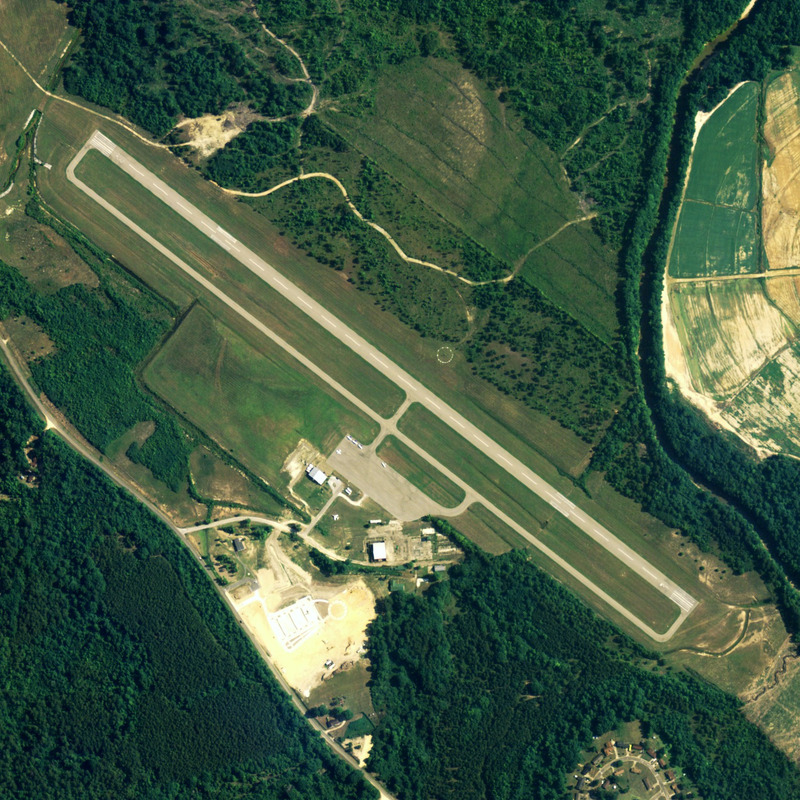
| NAIP aerial image, 30 June 2006 |
| IATA: none â ICAO: none â FAA LID: 06A |
| Summary |
| Airport type |
Public |
| Owner |
City of Tuskegee |
| Serves |
Tuskegee, Alabama |
| Location |
Tuskegee, Alabama |
| Elevation AMSL |
264 ft / 80 m |
| Coordinates |
32°27â²38â³N 085°40â²48â³W / 32.46056°N 85.68°W / 32.46056; -85.68 |
| Runways |
| Direction |
Length |
Surface |
| ft |
m |
| 13/31 |
5,003 |
1,525 |
Asphalt |
| Statistics (2009) |
| Aircraft operations |
19,530 |
| Based aircraft |
9 |
| Source: Federal Aviation Administration |
Moton Field Municipal Airport (FAA LID: 06A) is a public use airport located three nautical miles (6 km) north of the central business district of Tuskegee, a city in Macon County, Alabama, United States. It is owned by the City of Tuskegee.
Moton Field is home to the Tuskegee Airmen National Historic Site. History
Moton Field, built between 1940 and 1942, was named for Robert Russa Moton, the second president of the Tuskegee Institute. It was a basic flight training facility for the Tuskegee Airmen during World War II. Advanced training was done at the nearby Tuskegee Army Air Field, also known as Sharpe Field.
In 1972, the City of Tuskegee took ownership of Moton Field and continues to operate it as a municipal airport.
Facilities
Moton Field Municipal Airport covers an area of 275 acres (111 ha) at an elevation of 264 feet (80 m) above mean sea level. It has one asphalt paved runway designated 13/31 which measures 5,003 by 100 feet (1,525 x 30 m).
For the 12-month period ending January 22, 2009, the airport had 19,530 general aviation aircraft operations, an average of 53 per day. At that time there were 9 aircraft based at this airport, all single-engine.
The above content comes from Wikipedia and is published under free licenses – click here to read more.
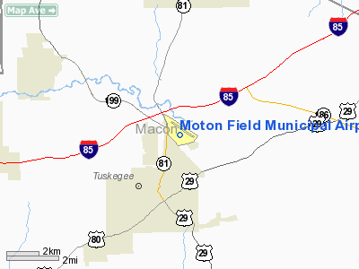
Location
& QuickFacts
|
FAA Information Effective: |
2007-01-18 |
|
Airport
Identifier: |
06A |
|
Airport
Status: |
Operational |
|
Longitude/Latitude: |
085-40-48.1300W/32-27-37.6980N
-85.680036/32.460472 (Estimated) |
|
Elevation: |
264 ft / 80.47 m (Surveyed) |
|
Land: |
275 acres |
|
From
nearest city: |
3 nautical miles N of Tuskegee, AL |
|
Location: |
Macon County, AL |
|
Magnetic Variation: |
01W (1985) |
Owner
& Manager
|
Ownership: |
Publicly owned |
|
Owner: |
City Of Tuskegee |
|
Address: |
101 Fonville St
Tuskegee, AL 36083 |
|
Phone
number: |
334-727-2180 |
|
Manager: |
Col Roosevelt Lewis
ADDNL CTCS: JOHN BANKS 334-727-7917. |
|
Address: |
1727 Chief Anderson St
Tuskegee, AL 36083 |
|
Phone number: |
334-724-0602 |
Airport
Operations and Facilities
|
Airport Use: |
Open to public |
|
Wind
indicator: |
Yes |
|
Segmented
Circle: |
Yes |
|
Control
Tower: |
No |
|
Lighting
Schedule: |
DUSK-DAWN
ACTVT MIRL RY 13/31 AND PAPI RYS 13 & 31 - CTAF. |
|
Beacon
Color: |
Clear-Green (lighted land airport)
OTS INDEFLY. |
|
Landing
fee charge: |
No |
|
Sectional
chart: |
Atlanta |
|
Region: |
ASO - Southern |
|
Boundary
ARTCC: |
ZTL - Atlanta |
|
Tie-in
FSS: |
ANB - Anniston |
|
FSS
on Airport: |
No |
|
FSS
Toll Free: |
1-800-WX-BRIEF |
|
NOTAMs
Facility: |
ANB (NOTAM-d service avaliable) |
|
Federal Agreements: |
NGY |
Airport
Communications
|
CTAF: |
122.800 |
|
Unicom: |
122.800 |
Airport
Services
|
Fuel available: |
100LLA
FOR AFT HRS FUEL CALL 334-727-7917. |
|
Airframe Repair: |
MAJOR |
|
Power Plant Repair: |
MAJOR |
|
Bottled
Oxygen: |
NONE |
|
Bulk
Oxygen: |
NONE |
|
Runway Information
Runway 13/31
|
Dimension: |
5003 x 100 ft / 1524.9 x 30.5 m |
|
Surface: |
ASPH, Good Condition |
|
Weight
Limit: |
Single wheel: 28500 lbs. |
|
Edge
Lights: |
Medium |
|
|
Runway 13 |
Runway 31 |
|
Longitude: |
085-41-10.8640W |
085-40-25.3840W |
|
Latitude: |
32-27-53.2120N |
32-27-22.1710N |
|
Elevation: |
263.00
ft |
263.00
ft |
|
Alignment: |
127 |
127 |
|
Traffic
Pattern: |
Left |
Left |
|
Markings: |
Basic, Good Condition |
Basic, Good Condition |
|
Crossing
Height: |
30.00
ft |
30.00
ft |
|
VASI: |
2-light PAPI on left side |
2-light PAPI on left side |
|
Visual
Glide Angle: |
3.00° |
3.00° |
|
Obstruction: |
12 ft brush, 405.0 ft from runway, 75 ft left
of centerline, 17:1 slope to clear |
21 ft trees, 376.0 ft from runway, 128 ft left
of centerline, 8:1 slope to clear |
|
Radio Navigation
Aids
|
ID |
Type |
Name |
Ch |
Freq |
Var |
Dist |
|
DER |
NDB |
Alexander City |
|
382.00 |
01W |
28.9 nm |
|
AWS |
NDB |
Lawson |
|
335.00 |
02W |
34.8 nm |
|
TO |
NDB |
Blood |
|
365.00 |
01W |
43.6 nm |
|
PIM |
NDB |
Pine Mountain |
|
272.00 |
03W |
46.9 nm |
|
XNE |
NDB |
Spring Hill |
|
281.00 |
00E |
49.0 nm |
|
MXF |
TACAN |
Maxwell |
097X |
|
03E |
35.3 nm |
|
TGE |
VOR/DME |
Tuskegee |
120X |
117.30 |
02E |
1.5 nm |
|
LSF |
VOR/DME |
Lawson |
051X |
111.40 |
02W |
35.7 nm |
|
CSG |
VORTAC |
Columbus |
118X |
117.10 |
01E |
34.8 nm |
|
MGM |
VORTAC |
Montgomery |
058X |
112.10 |
03E |
35.5 nm |
|
EUF |
VORTAC |
Eufaula |
029X |
109.20 |
02E |
41.5 nm |
|
LGC |
VORTAC |
Lagrange |
103X |
115.60 |
01E |
42.7 nm |
Remarks
- PARALLEL
TWY LGTD FULL LENGTH.
Based
Aircraft
|
Aircraft
based on field: |
15 |
|
Single
Engine Airplanes: |
14 |
|
Helicopters: |
1 |
Operational Statistics
Time Period: 1999-03-23
- 2000-03-21
|
Aircraft
Operations: |
54/Day |
|
General
Aviation Local: |
33.7% |
|
General
Aviation Itinerant: |
66.3% |
Moton Field Municipal Airport
Address:
Macon County, AL
Tel:
334-727-2180,
334-724-0602
Images
and information placed above are from
http://www.airport-data.com/airport/06A/
We
thank them for the data!
| General
Info |
| Country |
United
States |
| State |
ALABAMA
|
| FAA ID |
06A
|
| Latitude |
32-27-37.698N
|
| Longitude |
085-40-48.130W
|
| Elevation |
264 feet
|
| Near City |
TUSKEGEE
|
We don't guarantee the information is fresh and accurate. The data may
be wrong or outdated.
For more up-to-date information please refer to other sources.
|
|