 |
|
Montgomery Regional (Dannelly Field) Airport |
Coordinates: 32°18â²02â³N 086°23â²38â³W / 32.30056°N 86.39389°W / 32.30056; -86.39389
Montgomery Regional Airport
Dannelly Field |
 |
| IATA: MGM â ICAO: KMGM â FAA LID: MGM |
| Summary |
| Airport type |
Public |
| Owner |
Montgomery Airport Authority |
| Location |
Montgomery, Alabama |
| Elevation AMSL |
221 ft / 67 m |
| Website |
MontgomeryAirport.org |
| Runways |
| Direction |
Length |
Surface |
| ft |
m |
| 3/21 |
4,010 |
1,222 |
Asphalt |
| 10/28 |
9,010 |
2,746 |
Asphalt |
| Statistics (2009) |
| Aircraft operations |
71,575 |
| Based aircraft |
77 |
| Source: Federal Aviation Administration |
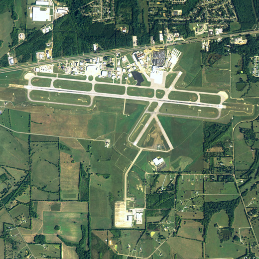
Montgomery Regional Airport (IATA: MGM, ICAO: KMGM, FAA LID: MGM), also known as Dannelly Field, is a joint civil-military public airport located six miles (9.7 km) southwest of the central business district of Montgomery, a city in Montgomery County and the capital of the U.S. state of Alabama. It is mostly used for military and general aviation, but is also served by three commercial airlines. History
From the outset, commercial aviation and military aviation have been intertwined in Montgomery. The first commercial air services in Montgomery operated at Maxwell Field, a military facility founded by the Wright Brothers west of the city. To provide for the separate needs of commercial aviation, the City of Montgomery opened its original municipal airport in 1929 east of the city. This facility was later named Gunter Field and was served by a predecessor of American Airlines. Eastern Air Lines subsequently took over service at Gunter.
In 1940 the War Department chose Gunter for a new pilot training facility. Gunter quickly became congested, Eastern Airlines was forced to move temporarily to Maxwell, and the city purchased a tract southwest of downtown on US 80 to replace Gunter for civilian aviation. Separately, the Army Air Force identified a need for seven auxiliary fields in the vicinity of Gunter and the city and USAAF agreed that the city's newly purchased site would also serve as Gunter's auxiliary field #6. It opened in 1943 and was named for ENS Clarence Moore Dannelly, Jr., USN, a Navy pilot killed in a 1940 training accident and considered to be the first casualty of World War II from Montgomery. The old Army Air Force hangars are now part of the Montgomery Aviation complex. The original three runways, and their original dimensions, were:
- 3/21: 4,000 x 150 ft (46 m) Still exists today.
- 9/27: 3,500 x 150 ft (46 m) Extended to 7,000 ft (2,100 m) in 1955. Extended to 9,000 ft (2,700 m) in 1963. Redesignated 10/28 in 1992.
- 15/33: 4,000 x 150 ft (46 m) Closed in 1981. Some portions remain as taxiway and apron.
When Dannelly Field opened, Eastern moved its operations there. The city took title to Dannelly in 1946, although joint commercial and military use continued, and erected a permanent passenger terminal and control tower north of Runway 9/27 in 1955. While Runway 9/27 was being rebuilt in 1963, and again in 1970, commercial flights were temporarily diverted to Maxwell.
Facilities
Montgomery Regional (Dannelly Field) Airport covers 1,907 acres (772 ha) and has two runways:
- Runway 10/28: 9,010 x 150 ft. (2,746 x 46 m), Surface: Asphalt. CAT I ILS and approach lights on both ends.
- Runway 3/21: 4,010 x 150 ft. (1,222 x 46 m), Surface: Asphalt
The air carrier terminal has been expanded and modified several times since 1955. A $40 million capital program that finished in November 2006 doubled the size of the terminal, completely transformed its appearance, and modernized it with 2nd floor boarding, jetway loading bridges, and a rotunda with a domed ceiling that simulates sunrises, sunsets, and stars at night.
The air carrier apron, as well as the main runway and taxiways, can accommodate aircraft as large as the Boeing 747 and Antonov 124.
There are numerous corporate aviation hangars and support facilities. A proposal to extend Runway 3/21 to 7,200 feet (2,200 m) is currently under consideration. A new control tower was built in 1996 south of Runway 10/28.
Military use
The Alabama Air National Guard's 187th Fighter Wing (187 FW), based on the west side of the airport, operates a squadron of F-16C aircraft. The 187th Fighter Wing evolved from the 160th Tactical Reconnaissance Squadron that began operating at Dannelly Field in 1953. During its history, the 187th and its predecessor have based several types of aircraft at Montgomery, including the RF-51 Mustang, RF-80 Shooting Star, RF-84 Thunderflash, RF-4 Phantom II, F-4 Phantom II and C-131 Samaritan.
The Alabama Army National Guard has an aviation support facility on the south side of the airport. Although primarily oriented to helicopter operations, fixed-wing aircraft can also be accommodated.
An Air National Guard Aircraft Rescue and Fire Fighting (ARFF) unit is located at the airport, equipped with multiple fire fighting and rescue vehicles, to augment the airport's civilian ARFF unit.
Airlines and destinations
| Airlines |
Destinations |
| American Eagle |
Dallas/Fort Worth |
| Delta Connection operated by Atlantic Southeast Airlines |
Atlanta, Memphis |
| Delta Connection operated by Pinnacle Airlines |
Atlanta |
| US Airways Express operated by PSA Airlines |
Charlotte |
Former airlines
Past airlines since 1955 have included Eastern Air Lines, Eastern Metro Express, Southern Airways, Republic Airlines, Piedmont Aviation, Sun Airlines, Southeast Air, South Central Air Transport (SCAT), Air Illinois, Ocean Airways, Continental Airlines, Continental Express and Northwest Airlink. Although 50-70 passenger regional jets are now the predominant scheduled aircraft, in past years airlines such as Delta operated the DC-9, MD-80, 737, 727, and briefly even the DC-8 on a scheduled basis.
The above content comes from Wikipedia and is published under free licenses – click here to read more.
Location
& QuickFacts
|
FAA Information Effective: |
2007-01-18 |
|
Airport
Identifier: |
MGM |
|
Airport
Status: |
Operational |
|
Longitude/Latitude: |
086-23-38.3000W/32-18-02.3000N
-86.393972/32.300639 (Estimated) |
|
Elevation: |
221 ft / 67.36 m (Surveyed) |
|
Land: |
1907 acres |
|
From
nearest city: |
6 nautical miles SW of Montgomery, AL |
|
Location: |
Montgomery County, AL |
|
Magnetic Variation: |
01W (1990) |
Owner
& Manager
|
Ownership: |
Publicly owned |
|
Owner: |
Montgomery Airport Authority |
|
Address: |
4445 Selma Hwy
Montgomery, AL 36108 |
|
Phone number: |
334-281-5040 |
|
Manager: |
Phil B. Perry |
|
Address: |
4445 Selma Hwy
Montgomery, AL 36108 |
|
Phone number: |
334-281-5040 |
Airport
Operations and Facilities
|
Airport Use: |
Open to public |
|
Wind
indicator: |
Yes |
|
Segmented
Circle: |
Yes |
|
Control
Tower: |
Yes |
|
Lighting
Schedule: |
DUSK-DAWN
WHEN ATCT CLSD HIRL RY 10/28 PRESET MED INTST AND MIRL RY
03/21 PRESET ON LOW INTST. ACTVT REIL RY 03, PAPI RY 21 AND MALSR RYS 10
& 28 - CTAF. |
|
Beacon
Color: |
Clear-Green (lighted land airport) |
|
Landing
fee charge: |
No |
|
Sectional
chart: |
Atlanta |
|
Region: |
ASO - Southern |
|
Boundary
ARTCC: |
ZTL - Atlanta |
|
Tie-in
FSS: |
ANB - Anniston |
|
FSS
on Airport: |
No |
|
FSS
Toll Free: |
1-800-WX-BRIEF |
|
NOTAMs
Facility: |
MGM (NOTAM-d service avaliable) |
|
Certification
type/date: |
I B S 05/1973
CLSD TO UNSKED ACR OPNS & LRG MIL ACFT REQUIRING PARKING,
EXCP WITH 72 HRS PPR CTC AMGR 334-281-5040. |
|
Federal Agreements: |
NGY3 |
Airport
Communications
|
CTAF: |
119.700 |
|
Unicom: |
122.950 |
Airport
Services
|
Fuel available: |
100LLA |
|
Airframe Repair: |
MAJOR |
|
Power Plant Repair: |
MAJOR |
|
Bottled
Oxygen: |
NONE |
|
Bulk
Oxygen: |
HIGH/LOW
UP TO 2200 PSI. |
|
Runway Information
Runway 03/21
|
Dimension: |
4010 x 150 ft / 1222.2 x 45.7 m |
|
Surface: |
ASPH, Good Condition |
|
Weight
Limit: |
Single wheel: 40000 lbs.
Dual wheel: 95000 lbs.
DC-10-10
320; DC-10-30 & 40 400; L1011 350; B747 500. |
|
Edge
Lights: |
Non-standard lighting system
NSTD MIRL; LGTS LCTD 35 FT FROM EDGE OF RY. |
|
|
Runway 03 |
Runway 21 |
|
Longitude: |
086-23-38.8935W |
086-23-13.4709W |
|
Latitude: |
32-17-41.9765N |
32-18-15.2626N |
|
Elevation: |
221.00
ft |
186.00
ft |
|
Alignment: |
33 |
127 |
|
Traffic
Pattern: |
Left |
Left |
|
Markings: |
Basic, Good Condition |
Basic, Good Condition |
|
Crossing
Height: |
43.00
ft |
40.00
ft |
|
VASI: |
4-light PAPI on left side |
4-light PAPI on left side |
|
Visual
Glide Angle: |
3.00° |
3.00° |
|
Runway
End Identifier: |
Yes
OTS INDEFLY. |
|
|
Obstruction: |
22 ft fence, 700.0 ft from runway, 22:1 slope
to clear |
54 ft tree, 1300.0 ft from runway, 300 ft left
of centerline, 20:1 slope to clear |
|
Runway 10/28
|
Dimension: |
9010 x 150 ft / 2746.2 x 45.7 m |
|
Surface: |
ASPH, Good Condition |
|
Surface
Treatment: |
Saw-cut or plastic Grooved |
|
Weight
Limit: |
Single wheel: 105000 lbs.
Dual wheel: 116000 lbs.
Dual tandem wheel: 180000 lbs.
DC-10-10 320; DC-10-30 & 40 400; L1011 350; B747 500. |
|
Edge
Lights: |
High
NSTD MIRL; LGTS LCTD 35 FT FROM EDGE OF RY. |
|
|
Runway 10 |
Runway 28 |
|
Longitude: |
086-24-35.9173W |
086-22-51.5223W |
|
Latitude: |
32-18-08.6371N |
32-17-59.2993N |
|
Elevation: |
219.00
ft |
195.00
ft |
|
Alignment: |
96 |
127 |
|
ILS
Type: |
ILS |
ILS |
|
Traffic
Pattern: |
Right |
Left |
|
Markings: |
Precision instrument, Good Condition |
Precision instrument, Good Condition |
|
Arresting: |
BAK14 |
BAK14 |
|
Crossing
Height: |
64.00
ft |
75.00
ft |
|
VASI: |
4-light PAPI on left side |
4-light PAPI on left side |
|
Visual
Glide Angle: |
3.00° |
3.00° |
|
RVR
Equipment: |
touchdown |
|
|
Approach
lights: |
MALSR |
MALSR |
|
Obstruction: |
35 ft tree, 1990.0 ft from runway, 630 ft left
of centerline, 34:1 slope to clear |
65 ft tree, 2800.0 ft from runway, 600 ft right
of centerline, 40:1 slope to clear |
|
Radio Navigation
Aids
|
ID |
Type |
Name |
Ch |
Freq |
Var |
Dist |
|
SE |
NDB |
Pollk |
|
344.00 |
01W |
27.2 nm |
|
PRN |
NDB |
Persimmon/dcmsnd |
|
359.00 |
00E |
29.3 nm |
|
TO |
NDB |
Blood |
|
365.00 |
01W |
31.9 nm |
|
GGY |
NDB |
Gragg-wade |
|
338.00 |
01E |
35.0 nm |
|
DER |
NDB |
Alexander City |
|
382.00 |
01W |
41.1 nm |
|
XNE |
NDB |
Spring Hill |
|
281.00 |
00E |
42.8 nm |
|
XBR |
NDB |
Brantley |
|
410.00 |
00E |
44.7 nm |
|
MXF |
TACAN |
Maxwell |
097X |
|
03E |
4.9 nm |
|
JYU |
VOR/DME |
Junior |
083X |
113.60 |
01W |
30.5 nm |
|
TGE |
VOR/DME |
Tuskegee |
120X |
117.30 |
02E |
38.4 nm |
|
MGM |
VORTAC |
Montgomery |
058X |
112.10 |
03E |
6.0 nm |
Remarks
- NO
180 DEG TURNS ON RY 10/28 BY DC-9 OR LARGER ACFT.
- ACR
& LRG MIL ACFT SHOULD NOT TAXI ON RY 03/21.
- ANG:
BASE OPS FACILITY AVBL 1200-2230Z++.
- ANG:
ACFT PARKING EXTREMELY LMTD CTC BASE OPNS FOR PARKING INSTR. TSNT PARKING
EXTREMELY LIMITED. TRANSPORT ACFT LMTD TO MINIMUM THRUST WHILE ON ANG
RAMP.
- ANG:
PPR FOR USE OF ANG RAMP CTC ANG OPNS DSN358-9255/9256/C334-394-7255/7256.
- EXERCISE
EXTREME CAUTION BETWEEN DEC-MAR: LARGE FLOCKS OF BIRDS MIGRATE DAILY
AT DAWN AND SUNSET FROM ALONG THE ALABAMA RIVER.
- TO
AREAS SOUTH OF THE RIVER; THE BIRDS FLYWAY CROSSES THE FINAL APCH TO
RY 28.
- TRAFFIC
PATTERN ALTITUDE IS 1200' MSL FOR CONV. ACFT AND 1700' MSL FOR JET ACFT.
- ON
APCH TO RY 10 & 28 DO NOT MISTAKE MAXWELL AFB - 6 NM NORTH FOR DANNELLY
FIELD.
- NUMEROUS
HEL AND LOW SPEED ACFT INVOF ARPT DURG DALGT HRS.
- TRANSPORT
ACFT LTD TO MIN THRUST WHILE ON RAMP.
Based
Aircraft
|
Aircraft
based on field: |
136 |
|
Single
Engine Airplanes: |
52 |
|
Multi
Engine Airplanes: |
16 |
|
Jet Engine
Airplanes: |
9 |
|
Helicopters: |
2 |
|
Military: |
57 |
Major Carriers
Serving This Airport
| Atlantic Southeast Airlines |
80.0% |
| Expressjet Airlines Inc. |
20.0% |
Most Popular Destinations
|
Hartsfield
- Jackson Atlanta Intl (ATL) |
70.7% |
|
George
Bush Intercontinental/houston (IAH) |
20.0% |
|
Cincinnati/northern
Kentucky Intl (CVG) |
9.3% |
Most Popular Aircraft
|
N642AS |
3.2% |
|
N632AS |
3.0% |
|
N631AS |
2.9% |
|
N637AS |
2.7% |
|
N643AS |
2.5% |
|
N641AS |
2.5% |
|
N640AS |
2.1% |
|
N633AS |
2.0% |
|
N636AS |
2.0% |
|
N635AS |
1.8% |
Operational Statistics
Time Period: 2005-04-01
- 2006-03-31
|
Aircraft
Operations: |
193/Day |
|
Commerical: |
4.5% |
|
Air Taxi: |
12.5% |
|
General
Aviation Local: |
7.7% |
|
General
Aviation Itinerant: |
34.4% |
|
Military: |
40.9% |
Montgomery Regional (dannelly Field) Airport
Address:
Montgomery County, AL
Tel:
334-281-5040
Images
and information placed above are from
http://www.airport-data.com/airport/MGM/
We
thank them for the data!
| General
Info |
| Country |
United
States |
| State |
ALABAMA
|
| FAA ID |
MGM
|
| Latitude |
32-18-02.319N
|
| Longitude |
086-23-38.314W
|
| Elevation |
221 feet
|
| Near City |
MONTGOMERY
|
We don't guarantee the information is fresh and accurate. The data may
be wrong or outdated.
For more up-to-date information please refer to other sources.
|
|


