|
 |
|
||||
|
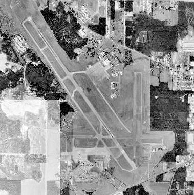
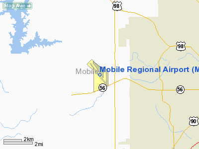
Image of Bates Field, 21 February 1952 Mobile Regional Airport (IATA: MOB, ICAO: KMOB, FAA LID: MOB) is a joint public and military use airport located 11 nautical miles (20 km) west of the central business district of Mobile, a city in Mobile County, Alabama, United States. It is also near Pascagoula, Mississippi. The airport, owned and operated by the Mobile Airport Authority, is an independent, self-funded entity that receives no local tax dollars. A total of 603,192 people used the airport in 2006. As of June 2007, the airport had 50 daily flights. The airport is also home to Coast Guard Aviation Training Center Mobile, providing advanced training to U.S. Coast Guard pilots and aircrew in the HH-65 Dolphin, HH-60 Jayhawk, HU-25 Guardian and HC-144 Ocean Sentry. Facilities and aircraftMobile Regional Airport covers an area of 1,717 acres (695 ha) at an elevation of 219 feet (67 m) above mean sea level. It has two asphalt paved runways: 14/32 is 8,502 by 150 feet (2,591 x 46 m) and 18/36 is 4,376 by 150 feet (1,334 x 46 m). It also has one helipad designated H1 which measures 100 by 100 feet (30 x 30 m). The terminal at Mobile Regional Airport includes newly renovated shops and restaurants, such as local favorite Carpe Diem Coffee and Tea, car rental agencies and handicap accessible elevators. For the 12-month period ending December 31, 2008, the airport had 116,757 aircraft operations, an average of 319 per day: 61% military, 21% general aviation, 14% air taxi and 3% scheduled commercial. At that time there were 59 aircraft based at this airport: 58% single-engine, 7% multi-engine, 5% jet, 2% helicopter and 29% military. Airlines and destinationsThe major carriers out of Mobile are Continental and Delta, based on the number of daily flights serving the airport. Delta dropped several flights in 2006 and Continental took up the slack, adding flights from the airport. As of December 2006, Delta offered six weekday flights to Atlanta and one to its Cincinnati hub. The Cincinnati schedule has come and gone previously, and was again being discontinued on December 12, 2006. Continental offered seven weekday flights to Houston. Additional weekday departures were as follows: Charlotte (4 flights), Memphis (3 flights), and Dallas/Fort Worth (3 flights). Schedules were slightly reduced on the weekends. United Airlines previously served MOB from its hubs in Chicago and Washington, DC, but service was canceled and the airline withdrew from Mobile in September 2001âjust a few weeks after the terrorist attacks of September 11th. Service to Chicago was restored in April 2007, by American Airlines, but discontinued in September 2008. Of the major full-service carriers in the United States, only United does not currently serve Mobile. The three major airline alliances -- SkyTeam, Star Alliance, and Oneworld -- are all represented at MOB. Mobile Regional Airport is primarily served by regional airlines doing business on behalf of the major network airlines, as listed below. The only network carrier to serve Mobile with its mainline planes is Delta Air Lines. Approximately 99.56% of scheduled services utilize jet aircraft. The following routes are flown nonstop or direct from Mobile:
AirfaresThe airport has a reputation for high domestic fares, and they are usually attributed to the lack of a true low-cost carrier (LCC) serving the airport, such as JetBlue or Southwest. LCC AirTran Airways served the airport for a time, but Delta and other airlines matched fares on the routes served by AirTran and passengers continued to fly the traditional network carriers. Ultimately, AirTran moved out and fares increased once again. AirTran later entered the Pensacola market, and fares dropped significantly from Pensacola Regional Airport. Because of this, many people drive about an hour in either direction to Pensacola, Florida or Gulfport, Mississippi. However, fares from Pensacola are lower primarily on routes served by AirTran. On other routes, including international services, Mobile and Pensacola offer similar fares. In order to attract and maintain frequent flyers, Mobile Regional Airport was the first to offer an Airport Frequent Flyer Program, called Passport. Passport was launched with a media blitz and new slogan: "Fly Smarter, Fly Mobile." The Mobile Airport Authority encourages passengers to use multiple airlines to stimulate more competition and lower fares, and it continues to work to attract a low-cost carrier. The Authority also believes that both Mobile and Pensacola would be better served if a single airport was built to serve both cities in Baldwin County, Alabama -- midway between both cities. However, the Authority claims that Pensacola officials do not want their airport in Alabama and have withdrawn from exploratory discussions., HistoryDuring World War II, the United States Army Air Forces used Mobile Regional airport. It was known as Bates Field and was commanded by the 533d Army Air Force Base Unit. It was used as a basic (level 1) pilot training airfield, under contract to Waterman Airlines, Inc. Flying training was performed with Fairchild PT-19s as the primary trainer. Also had several PT-17 Stearmans assigned. It was also used for glider pilot training, under contract to Mobile Area Soaring Corp. Used primarily C-47 Skytrains and Waco CG-4 unpowered gliders. The mission of the school was to train glider pilot students in proficiency in operation of gliders in various types of towed and soaring flight, both day and night, and in servicing of gliders in the field. In 1944 when the demand for pilots was reduced and the flying training ended, the airport was used as a transport airfield for the Domestic Transport Division, Air Transport Command. The above content comes from Wikipedia and is published under free licenses – click here to read more.
Runway InformationRunway 14/32
Runway 18/36
Helipad H1
Radio Navigation Aids
Remarks
Based Aircraft
Major Carriers Serving This Airport
Most Popular Destinations
Most Popular Aircraft
Operational StatisticsTime Period: 2005-01-01 - 2005-12-31
Mobile Regional Airport Address: Mobile County, AL Tel: 251-633-4510, 251-639-4684 Images
and information placed above are from We thank them for the data!
We don't guarantee the information is fresh and accurate. The data may
be wrong or outdated.
|
||||||||||||||||||||||||||||||||||||||||||||||||||||||||||||||||||||||||||||||||||||||||||||||||||||||||||||||||||||||||||||||||||||||||||||||||||||||||||||||||||||||||||||||||||||||||||||||||||||||||||||||||||||||||||||||||||||||||||||||||||||||||||||||||||||||||||||||||||||||||||||||||||||||||||||||||||||||||||||||||||||||||||||||||||||||||||||||||||||||||||||||||||||||||||||||||||||||||||||||||||||||||||||||||||||||||||||||||||||||||||||||||||||||||||||||||||

 |
|
Copyright 2004-2026 © by Airports-Worldwide.com, Vyshenskoho st. 36, Lviv 79010, Ukraine Legal Disclaimer |