|
 |
|
||||
|
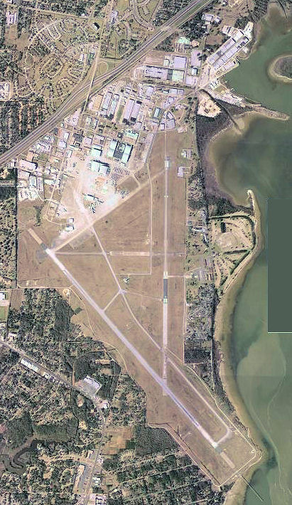
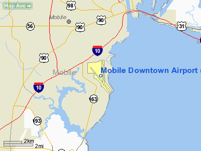
Mobile Downtown Airport (IATA: BFM, ICAO: KBFM, FAA LID: BFM) is a public use airport located three nautical miles (6 km) south of the central business district of Mobile, a city in Mobile County, Alabama, United States. It is also known as Brookley Field. The airport is part of the Brookley Complex, an industrial complex which lies on the western shore of Mobile Bay. It is owned and operated by the Mobile Airport Authority. Prior to 1969, the airport was an active military installation known as Brookley Air Force Base. According to the FAA's National Plan of Integrated Airport Systems for 2009â2013, it is categorized as a general aviation facility. This was a change from the 2007â2011 NPIAS Report, when it was categorized as a reliever airport. History
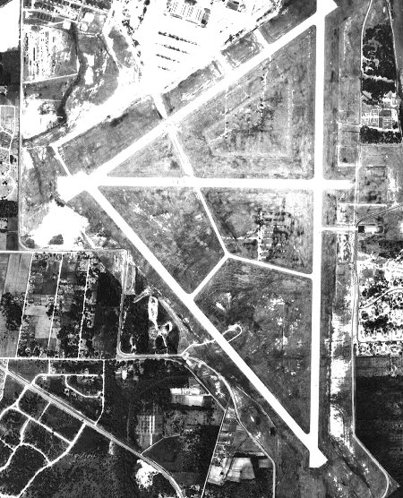
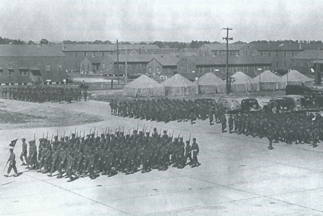
Brookley Complex had its aeronautical beginnings with Mobile's first municipal airport, the original Bates Field. However, the site itself had been occupied from the time of Mobile's founding, starting with the home of Mobile's founding father, Jean-Baptiste Le Moyne, Sieur de Bienville, in the early 18th century. In 1938 the Army Air Corps took over the then 1,000-acre (405 ha) Bates Field site and established the Brookley Army Air Field. The military was attracted to the site because of the area's generally good flying weather and the bay-front location, but Alabama Congressman Frank Boykin's influence in Washington was important in convincing the Army to locate the new military field in Mobile instead of Tampa, Florida. However, later that year, Tampa was also chosen for a military flying installation of its own, which would be named MacDill Field, home of present day MacDill Air Force Base. During World War II, Brookley Army Air Field became the major Army Air Forces supply base for the Air Material Command in the southeastern United States and the Caribbean. At this time it was a modification and repair center for various military aircraft, to include the B-29 Superfortress and P-51 Mustang, and employed 17,000 civilians, about 7500 of whom were women. Following World War II and the creation of an independent United States Air Force, the installation became Brookley Air Force Base. In 1962, the Air Material Command was renamed as the Air Force Logistics Command (AFLC) and Brookley AFB became the host base of the successor organization, Mobile Air Materiel Area (MOAMA). After an immediate end to many of the wartime jobs of World War II, the base's civilian workforce again expanded to around 16,000 people by 1962, a result of both the Cold War and other USAF base closings in other areas of the country. During this time, AFLC's Mobile Air Materiel Area (MOAMA) provided depot-level maintenance for various USAF aircraft of the period, to include the C-119 Flying Boxcar, C-131 Samaritan, F-84 Thunderstreak, RF-84 Thunderflash and the F-104 Starfighter. On 19 November 1964, the Department of Defense announced a progressive reduction in employment and the eventual closure of Brookley Air Force Base. Local legend says that this closure decision was due more to political retribution by the administration of President Lyndon B. Johnson for Alabama's support of Senator Barry Goldwater in the 1964 presidential election than an effort for actual economies within the Department of Defense. When it finally closed in June 1969, Brookley AFB represented the largest base closure in U.S. history up to that time, eliminating 10% of local jobs for the Mobile workforce, which provided an annual payroll of $95 million to the local economy. After closure, the base was returned to the City of Mobile. Later, the city transferred it to the Mobile Airport Authority and it became known as the Mobile Downtown Airport. The city had created the Mobile Airport Authority in 1982 to oversee the operation of the Mobile Regional Airport and what would become the Brookley Complex. The Mobile Airport Authority is autonomous and is not a part of the city or Mobile County. The Authorityâs five board members are appointed by Mobileâs Mayor, approved by the Mobile City Council, and serve 6 year terms. Many of the sets from the movie Close Encounters of the Third Kind were filmed in an aircraft hangar at Brookley. B-17 Flying Fortresses from Brookley Air Force Base were flown in the 1949 film Twelve O'Clock High, filmed largely at Eglin Air Force Base, Florida. In May 1976, the American Freedom Train was displayed at Brookley Center. Facilities and servicesBrookley is the largest industrial and transportation complex in the region with over 100 companies and 4000 employees on 1,700 acres (688 ha). The complex is home to many aerospace industries and features direct connections with Mobile Bay via its own docks, CSX railway, and with Interstate 10. The Brookley Complex is included in Mobile's Foreign Trade Zone 82, a zone that provides special customs procedures to U.S. plants engaged in international trade-related activities. Brookley includes the largest private employer in Mobile County, ST Mobile Aerospace Engineering, a subsidiary of Singapore Technologies Engineering. Brookley also serves as base of operations for Teledyne Continental Motors and the new Airbus Engineering Center. The airport has a control tower and has both a 9,600-by-150-foot (2,926 Ã 46 m) runway and a 7,800-by-150-foot (2,377 Ã 46 m) runway. Various instrument approaches to all runways are available, including an on-site VORTAC and instrument landing system (ILS). The complex is served by a 24-hour fixed base operator, the Downtown Air Center. In addition to the airport section, the complex is home to many aerospace industries and features direct connections with rail, road, and water transportation. For the 12-month period ending January 31, 2010, the airport had 82,820 aircraft operations, an average of 226 per day: 49% general aviation, 43% military, 5% air taxi, and 3% scheduled commercial. At that time there were 34 aircraft based at this airport: 65% single-engine, 18% multi-engine, 15% jet and 3% helicopter. Cargo and maintenance hubThe Brookley Complex is a maintenance facility for FedEx Express, US Airways, and United Airlines. FedEx Express also uses the complex for three daily cargo flights from Memphis, Tennessee. UPS Airlines has one daily cargo flight from Louisville, Kentucky. The complex is also utilized by ABX Air (DHL). ExpansionAirbus North America selected the airport for the location of an engineering facility which opened in 2007. On 29 February 2008, the United States Air Force announced that a partnership between Northrop Grumman and EADS (Airbus' parent company) had won the contract to produce the new KC-45 aerial refueling tanker to replace the Boeing KC-135 Stratotanker. The contract would have worth up to $40 billion with 179 planes to be delivered over the next ten to fifteen years, with production of these aircraft will be at Brookley. EADS also announced plans to move its A330-200F freighter assembly line from France to Mobile as well. However, the contract was later cancelled. The KC-X program was later announced for re-competition. Although Northrop Grumman declined to bid (stating that it considered the RFP to be too heavily weighted in favor of Boeing and its planned Boeing 767 entry), on April 20, 2010, EADS announced it was re-entering the competition on a stand-alone basis, and intended to enter a bid with the KC-45 with final assembly at Brookley. The above content comes from Wikipedia and is published under free licenses – click here to read more.
Runway InformationRunway 14/32
Runway 18/36
Radio Navigation Aids
Remarks
Based Aircraft
Operational StatisticsTime Period: 2005-02-01 - 2006-01-31
Mobile Downtown Airport Address: Mobile County, AL Tel: 251-438-7334, 251-639-4683 Images
and information placed above are from We thank them for the data!
We don't guarantee the information is fresh and accurate. The data may
be wrong or outdated.
|
|||||||||||||||||||||||||||||||||||||||||||||||||||||||||||||||||||||||||||||||||||||||||||||||||||||||||||||||||||||||||||||||||||||||||||||||||||||||||||||||||||||||||||||||||||||||||||||||||||||||||||||||||||||||||||||||||||||||||||||||||||||||||||||||||||||||||||||||||||||||||||||||||||||||||||||||||||||||||||||||||||||||||||||||||||||||||||||||||||||||||||||||||||||||||||||||||||||||||||||||||||||||

 |
|
Copyright 2004-2026 © by Airports-Worldwide.com, Vyshenskoho st. 36, Lviv 79010, Ukraine Legal Disclaimer |