|
|
| Middleton Field |
 |
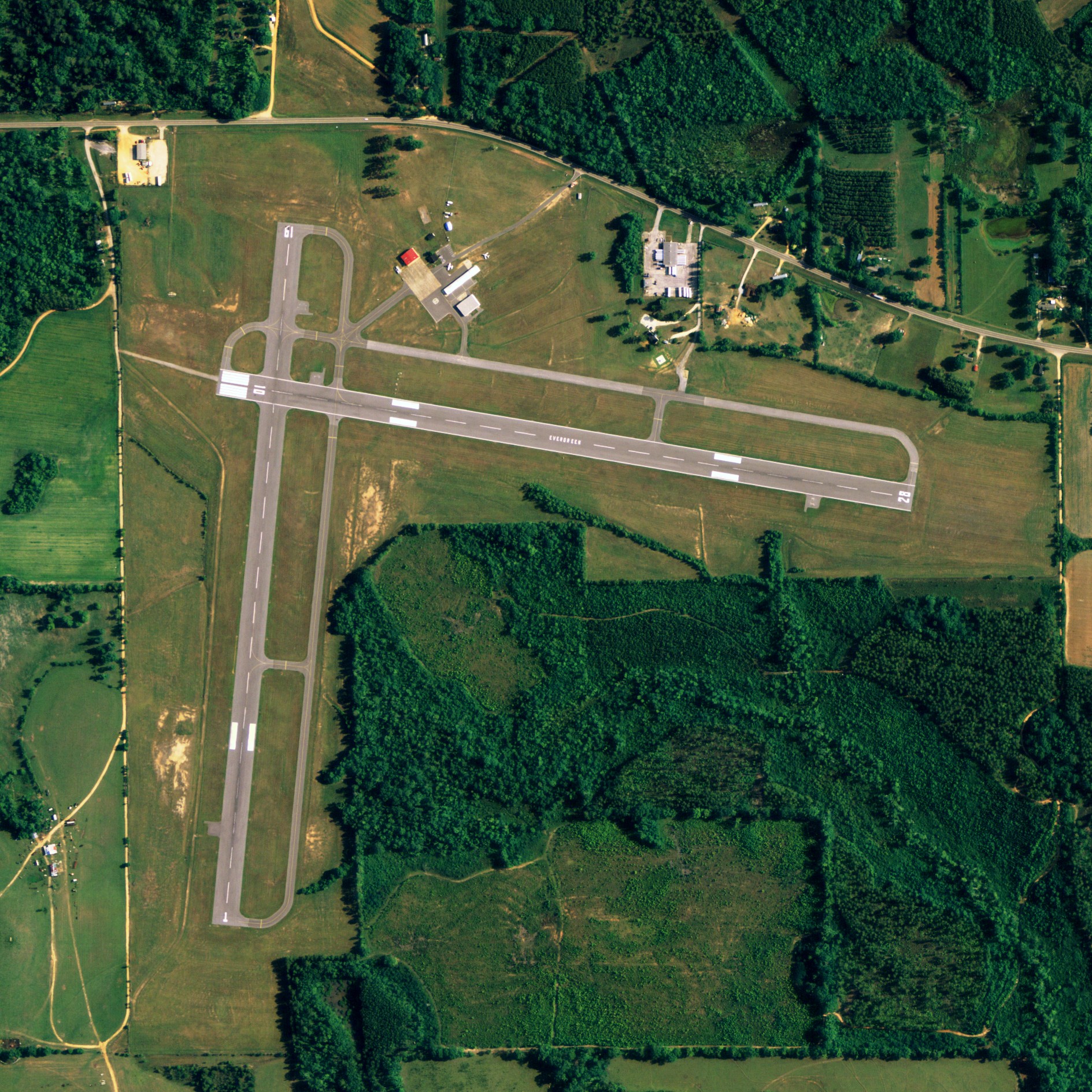
| NAIP aerial image, 30 June 2006 |
| IATA: none – ICAO: KGZH – FAA LID: GZH |
| Summary |
| Airport type |
Public / Military |
| Owner |
City of Evergreen |
| Serves |
Evergreen, Alabama |
| Elevation AMSL |
259 ft / 79 m |
| Coordinates |
31°24′57″N 087°02′39″W / 31.41583°N 87.04417°W / 31.41583; -87.04417 |
| Runways |
| Direction |
Length |
Surface |
| ft |
m |
| 1/19 |
4,000 |
1,219 |
Asphalt |
| 10/28 |
4,000 |
1,219 |
Asphalt |
| Statistics (2007) |
| Aircraft operations |
134,005 |
| Source: Federal Aviation Administration |
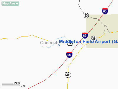
Middleton Field (ICAO: KGZH, FAA LID: GZH, formerly 39J) is a public-use airport located 5 nautical miles (9.3 km; 5.8 mi) west of the central business district of Evergreen, a city in Conecuh County, Alabama, United States. According to the FAA's National Plan of Integrated Airport Systems for 2009–2013, it is categorized as a general aviation facility. Although the airport is owned by the City of Evergreen, it is primarily used for flight training by the U.S Navy.
Although most U.S. airports use the same three-letter location identifier for the FAA and IATA, Middleton Field is assigned GZH by the FAA but has no designation from the IATA. Facilities and aircraft
Middleton Field covers an area of 200 acres (81 ha) which contains two asphalt paved runways (1/19 and 10/28) each measuring 4,000 x 150 ft (1,219 x 46 m). For the 12-month period ending June 25, 2007, the airport had 134,005 aircraft operations, an average of 367 per day: 96% military and 4% general aviation.
Accidents
On July 13, 1982, Lt. Cmdr. Barbara Allen Rainey, the U.S. Navy's first female pilot, and her student were killed in a crash while practicing touch-and-go landings at Middleton Field.
The above content comes from Wikipedia and is published under free licenses – click here to read more.
Location
& QuickFacts
|
FAA Information Effective: |
2007-01-18 |
|
Airport
Identifier: |
GZH |
|
Airport
Status: |
Operational |
|
Longitude/Latitude: |
087-02-38.5560W/31-24-56.8840N
-87.044043/31.415801 (Estimated) |
|
Elevation: |
259 ft / 78.94 m (Surveyed) |
|
Land: |
200 acres |
|
From
nearest city: |
5 nautical miles W of Evergreen, AL |
|
Location: |
Conecuh County, AL |
|
Magnetic Variation: |
01E (1985) |
Owner
& Manager
|
Ownership: |
Publicly owned |
|
Owner: |
City Of Evergreen |
|
Address: |
Po Box 229
Evergreen, AL 36401 |
|
Phone
number: |
334-578-1574 |
|
Manager: |
Bobby Tolbert |
|
Address: |
Po Box 229
Evergreen, AL 36401 |
|
Phone
number: |
334-578-1274 |
Airport
Operations and Facilities
|
Airport Use: |
Open to public |
|
Wind
indicator: |
Yes |
|
Segmented
Circle: |
No |
|
Control
Tower: |
No |
|
Lighting
Schedule: |
DUSK-DAWN
ACTVT MIRL RYS 01/19 & 10/28 AND PAPI RY 10 - CTAF. |
|
Beacon
Color: |
Clear-Green (lighted land airport) |
|
Landing
fee charge: |
No |
|
Sectional
chart: |
New Orleans |
|
Region: |
ASO - Southern |
|
Boundary
ARTCC: |
ZJX - Jacksonville |
|
Tie-in
FSS: |
ANB - Anniston |
|
FSS
on Airport: |
No |
|
FSS
Toll Free: |
1-800-WX-BRIEF |
|
NOTAMs
Facility: |
GZH (NOTAM-d service avaliable) |
|
Federal Agreements: |
N3 |
Airport
Communications
|
CTAF: |
122.700 |
|
Unicom: |
122.700 |
Airport
Services
|
Fuel available: |
100LLMOGAS |
|
Bottled
Oxygen: |
NONE |
|
Bulk
Oxygen: |
NONE |
|
Runway Information
Runway 01/19
|
Dimension: |
4000 x 150 ft / 1219.2 x 45.7 m |
|
Surface: |
ASPH, Fair Condition |
|
Edge
Lights: |
Medium |
|
|
Runway 01 |
Runway 19 |
|
Longitude: |
087-02-50.8770W |
087-02-46.5830W |
|
Latitude: |
31-24-33.4140N |
31-25-12.8260N |
|
Elevation: |
250.00
ft |
258.00
ft |
|
Alignment: |
5 |
127 |
|
Traffic
Pattern: |
Left |
Left |
|
Markings: |
Basic, Fair Condition |
Basic, Fair Condition |
|
Obstruction: |
34 ft trees, 890.0 ft from runway, 5 ft left
of centerline, 20:1 slope to clear |
68 ft trees, 1321.0 ft from runway, 223 ft
right of centerline, 16:1 slope to clear |
|
Runway 10/28
|
Dimension: |
4000 x 150 ft / 1219.2 x 45.7 m |
|
Surface: |
ASPH, Fair Condition |
|
Weight
Limit: |
Single wheel: 30000 lbs.
Dual wheel: 50000 lbs. |
|
Edge
Lights: |
Medium |
|
|
Runway 10 |
Runway 28 |
|
Longitude: |
087-02-51.3420W |
087-02-05.8210W |
|
Latitude: |
31-25-03.9220N |
31-24-57.3760N |
|
Elevation: |
259.00
ft |
243.00
ft |
|
Alignment: |
100 |
127 |
|
Traffic
Pattern: |
Left |
Left |
|
Markings: |
Basic, Fair Condition |
Basic, Fair Condition |
|
VASI: |
4-light PAPI on left side |
|
|
Obstruction: |
67 ft trees, 1300.0 ft from runway, 104 ft
right of centerline, 16:1 slope to clear |
55 ft tree, 1280.0 ft from runway, 10 ft left
of centerline, 19:1 slope to clear |
|
Radio Navigation
Aids
|
ID |
Type |
Name |
Ch |
Freq |
Var |
Dist |
|
PRN |
NDB |
Persimmon/dcmsnd |
|
359.00 |
00E |
34.2 nm |
|
JUY |
NDB |
Judd |
|
264.00 |
02W |
34.2 nm |
|
XBR |
NDB |
Brantley |
|
410.00 |
00E |
39.5 nm |
|
NSE |
TACAN |
Whiting |
070X |
|
01E |
41.6 nm |
|
NGS |
TACAN |
Santa Rosa |
063X |
|
01E |
48.5 nm |
|
UIA |
VOR |
Andalusia |
|
110.20 |
00E |
34.1 nm |
|
MVC |
VORTAC |
Monroeville |
115X |
116.80 |
04E |
16.1 nm |
|
CEW |
VORTAC |
Crestview |
106X |
115.90 |
03E |
40.1 nm |
Remarks
- INTENSIVE
NAVY PROP TRAINING MON-FRI SR-SS.
- DIST
MKRS ON BOTH SIDES OF RYS 10/28 & 01/19 ARE US NAVY EQUIP.
- TRAILER
MANNED BY USN RWY DUTY OFFICER WHEN A110-01 ACTIVE.
PERM USN CRASH CREW.
- ULTRALIGHT
ACTIVITY ON & INVOF ARPT.
- EXISTED
PRIOR TO FAA ACT.
Based
Aircraft
|
Aircraft
based on field: |
6 |
|
Single
Engine Airplanes: |
3 |
|
Ultralights: |
3 |
Operational
Statistics
Time Period:
1999-08-02 - 2000-07-31
|
Aircraft
Operations: |
358/Day |
|
General
Aviation Local: |
0.8% |
|
General
Aviation Itinerant: |
1.2% |
|
Military: |
98.0% |
Middleton Field Airport
Address:
Conecuh County, AL
Tel:
334-578-1574, 334-578-1274
Images
and information placed above are from
http://www.airport-data.com/airport/GZH/
We
thank them for the data!
| General
Info |
| Country |
United
States |
| State |
ALABAMA
|
| FAA ID |
GZH
|
| Latitude |
31-24-56.884N
|
| Longitude |
087-02-38.556W
|
| Elevation |
260 feet
|
| Near City |
EVERGREEN
|
We don't guarantee the information is fresh and accurate. The data may
be wrong or outdated.
For more up-to-date information please refer to other sources.
|
|