|
|
Merkel Field Sylacauga Municipal Airport |
Sylacauga Municipal Airport
Merkel Field |
 |
| IATA: none – ICAO: KSCD – FAA LID: SCD |
| Summary |
| Airport type |
Public |
| Owner |
City of Sylacauga |
| Serves |
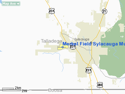
Sylacauga, Alabama |
| Elevation AMSL |
569 ft / 173 m |
| Coordinates |
33°10′19″N 086°18′20″W / 33.17194°N 86.30556°W / 33.17194; -86.30556 |
| Runways |
| Direction |
Length |
Surface |
| ft |
m |
| 9/27 |
5,390 |
1,643 |
Asphalt |
| Statistics (2007) |
| Aircraft operations |
28,316 |
| Based aircraft |
35 |
| Source: Federal Aviation Administration |
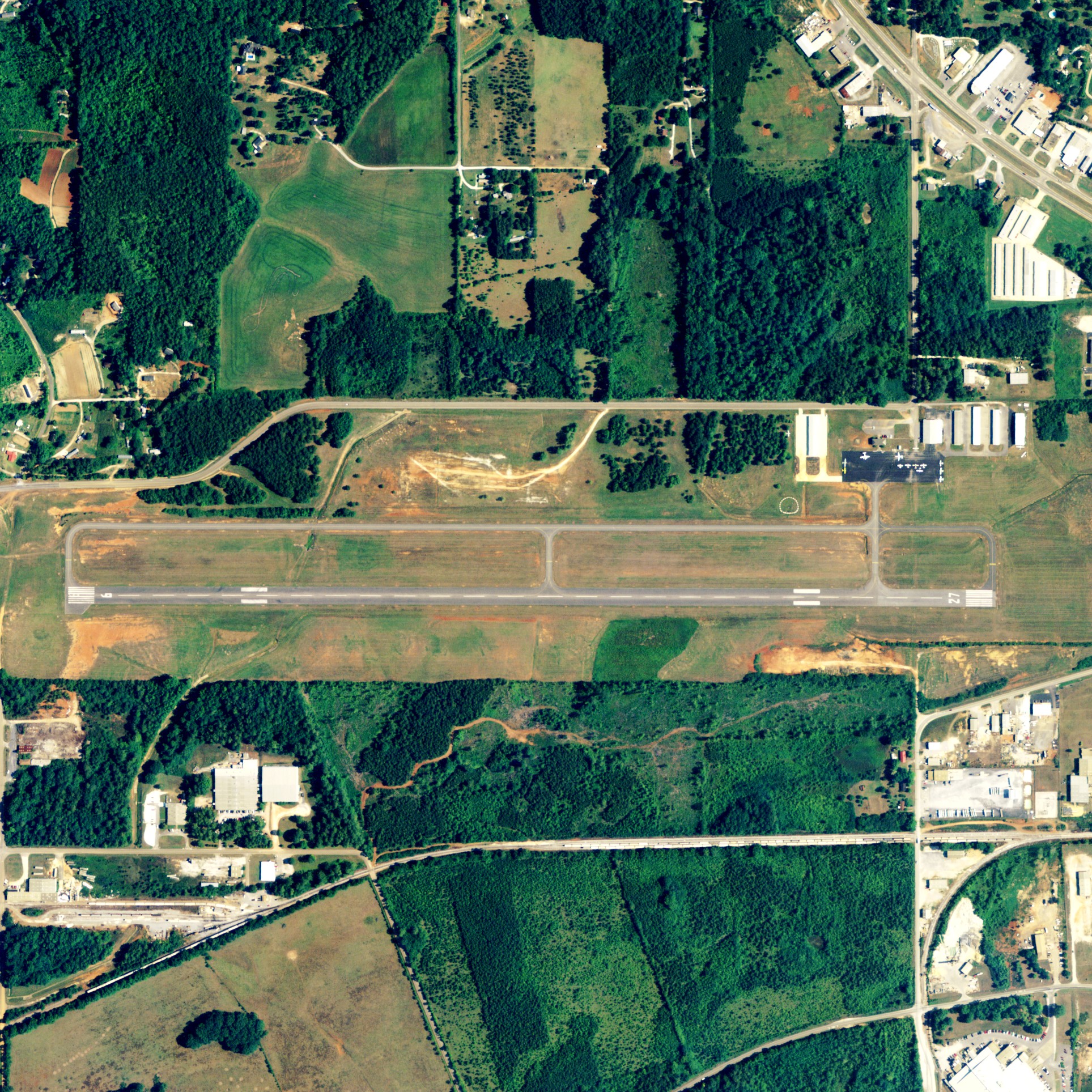
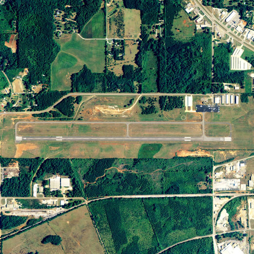
Sylacauga Municipal Airport (ICAO: KSCD, FAA LID: SCD), also known as Merkel Field, is a city-owned public-use airport located three nautical miles (6 km) west of the central business district of Sylacauga, a city in Talladega County, Alabama, United States.
Although most U.S. airports use the same three-letter location identifier for the FAA and IATA, this airport is assigned SCD by the FAA but has no designation from the IATA (which assigned SCD to Sulaco, Honduras).
Facilities and aircraft
Sylacauga Municipal Airport covers an area of 243 acres (98 ha) at an elevation of 569 feet (173 m) above mean sea level. It has one asphalt paved runway designated 9/27 which measures 5,390 by 100 feet (1,643 x 30 m).
For the 12-month period ending January 18, 2007, the airport had 28,316 aircraft operations, an average of 77 per day: 99% general aviation and 1% military. At that time there were 35 aircraft based at this airport: 86% single-engine, 6% multi-engine, 6% glider and 3% ultralight.
The above content comes from Wikipedia and is published under free licenses – click here to read more.
Location
& QuickFacts
|
FAA Information Effective: |
2007-01-18 |
|
Airport
Identifier: |
SCD |
|
Airport
Status: |
Operational |
|
Longitude/Latitude: |
086-18-19.9360W/33-10-18.6090N
-86.305538/33.171836 (Estimated) |
|
Elevation: |
569 ft / 173.43 m (Surveyed) |
|
Land: |
243 acres |
|
From
nearest city: |
3 nautical miles W of Sylacauga, AL |
|
Location: |
Talladega County, AL |
|
Magnetic Variation: |
03W (2005) |
Owner
& Manager
|
Ownership: |
Publicly owned |
|
Owner: |
City Of Sylacauga |
|
Address: |
Po Box 390
Sylacauga, AL 35150 |
|
Phone
number: |
256-249-4353 |
|
Manager: |
Ray Lett
AND LINDA LETT. |
|
Address: |
195 Airport Rd.
Sylacauga, AL 35151 |
|
Phone number: |
256-245-3246 |
Airport
Operations and Facilities
|
Airport Use: |
Open to public |
|
Wind
indicator: |
Yes |
|
Segmented
Circle: |
Yes |
|
Control
Tower: |
No |
|
Lighting
Schedule: |
DUSK-DAWN
ACTVT MIRL RY 09/27 - CTAF. |
|
Beacon
Color: |
Clear-Green (lighted land airport)
OTS INDEFLY. |
|
Landing
fee charge: |
No |
|
Sectional
chart: |
Atlanta |
|
Region: |
ASO - Southern |
|
Boundary
ARTCC: |
ZTL - Atlanta |
|
Tie-in
FSS: |
ANB - Anniston |
|
FSS
on Airport: |
No |
|
FSS
Toll Free: |
1-800-WX-BRIEF |
|
NOTAMs
Facility: |
ANB (NOTAM-d service avaliable) |
|
Federal Agreements: |
NGY |
Airport
Communications
|
CTAF: |
122.800 |
|
Unicom: |
122.800 |
Airport
Services
|
Fuel available: |
100LLA |
|
Airframe Repair: |
MAJOR |
|
Power Plant Repair: |
MAJOR |
|
Bottled
Oxygen: |
NONE |
|
Runway Information
Runway 09/27
|
Dimension: |
5390 x 100 ft / 1642.9 x 30.5 m |
|
Surface: |
ASPH, Fair Condition |
|
Weight
Limit: |
Single wheel: 20000 lbs. |
|
Edge
Lights: |
Medium |
|
|
Runway 09 |
Runway 27 |
|
Longitude: |
086-18-51.6360W |
086-17-48.2350W |
|
Latitude: |
33-10-18.8600N |
33-10-18.3540N |
|
Elevation: |
569.00
ft |
548.00
ft |
|
Alignment: |
91 |
127 |
|
Traffic
Pattern: |
Left |
Left |
|
Markings: |
Basic, Poor Condition
RY 09/27 MARKINGS BADLY FADED, RY NUMBERS UNREADABLE. |
Basic, Poor Condition |
|
VASI: |
2-box on left side |
2-box on left side
VASI OTS INDEFLY. |
|
Obstruction: |
31 ft tree, 620.0 ft from runway, 247 ft right
of centerline, 13:1 slope to clear |
28 ft trees, 1400.0 ft from runway, 42:1 slope
to clear |
|
Radio Navigation
Aids
|
ID |
Type |
Name |
Ch |
Freq |
Var |
Dist |
|
SCD |
NDB |
Sylacauga |
|
284.00 |
03W |
0.7 nm |
|
PLR |
NDB |
Pell City |
|
257.00 |
01E |
23.4 nm |
|
GGY |
NDB |
Gragg-wade |
|
338.00 |
01E |
24.6 nm |
|
DER |
NDB |
Alexander City |
|
382.00 |
01W |
24.7 nm |
|
BEQ |
NDB |
Bessemer |
|
368.00 |
00E |
32.2 nm |
|
BH |
NDB |
Mcden |
|
224.00 |
01W |
33.9 nm |
|
MXF |
TACAN |
Maxwell |
097X |
|
03E |
47.7 nm |
|
TDG |
VOR/DME |
Talladega |
025X |
108.80 |
02E |
27.6 nm |
|
GAD |
VOR/DME |
Gadsden |
070X |
112.30 |
02E |
49.6 nm |
|
VUZ |
VORTAC |
Vulcan |
091X |
114.40 |
02E |
42.3 nm |
|
OKW |
VORTAC |
Brookwood |
047X |
111.00 |
00E |
47.7 nm |
|
BHM |
VOT |
Birmingham Muni |
|
110.00 |
|
32.6 nm |
Remarks
- DEER
ON & INVOF ARPT.
- 17
FT WIDE TWY BTN MAIN RAMP TWY & HNGR AREA.
- ULTRALIGHT
ACTIVITY ON & INVOF ARPT.
Based
Aircraft
|
Aircraft
based on field: |
26 |
|
Single
Engine Airplanes: |
18 |
|
Multi
Engine Airplanes: |
2 |
|
Gliders: |
5 |
|
Ultralights: |
1 |
Operational Statistics
Time Period: 1999-06-09
- 2000-06-07
|
Aircraft
Operations: |
45/Day |
|
General
Aviation Local: |
7.5% |
|
General
Aviation Itinerant: |
90.0% |
|
Military: |
2.5% |
Merkel Field Sylacauga Municipal Airport
Address:
Talladega County, AL
Tel:
256-249-4353,
256-245-3246
Images
and information placed above are from
http://www.airport-data.com/airport/SCD/
We
thank them for the data!
| General
Info |
| Country |
United
States |
| State |
ALABAMA
|
| FAA ID |
SCD
|
| Latitude |
33-10-18.609N
|
| Longitude |
086-18-19.936W
|
| Elevation |
569 feet
|
| Near City |
SYLACAUGA
|
We don't guarantee the information is fresh and accurate. The data may
be wrong or outdated.
For more up-to-date information please refer to other sources.
|
|