 |
|
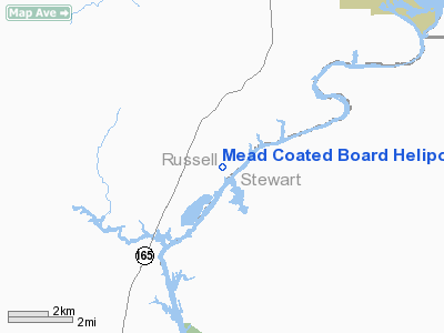
Mead Coated Board Heliport |
Location
& QuickFacts
|
FAA Information Effective: |
2007-01-18 |
|
Airport
Identifier: |
AL13 |
|
Airport
Status: |
Operational |
|
Longitude/Latitude: |
085-01-43.7490W/32-10-20.5480N
-85.028819/32.172374 (Estimated) |
|
Elevation: |
95
ft / 28.96 m (Estimated) |
|
Land: |
0
acres |
|
From
nearest city: |
1 nautical miles N of Cottonton, AL |
|
Location: |
Russell County, AL |
|
Magnetic Variation: |
01W (1985) |
Owner
& Manager
|
Ownership: |
Privately owned |
|
Owner: |
Mead Coated Board Inc |
|
Address: |
P O Box 940
Phenix City, AL 36868-0940 |
|
Phone
number: |
205-855-4711 |
|
Manager: |
David Arceneaux
MANAGER OF ENVIRONMENT, HEALTH & SAFETY. |
|
Address: |
P O Box 940
Phenix City, AL 36868-0940 |
|
Phone number: |
205-855-5157 |
Airport
Operations and Facilities
|
Airport Use: |
Private |
|
Wind
indicator: |
Yes |
|
Segmented
Circle: |
No |
|
Control
Tower: |
No |
|
Lighting
Schedule: |
PHONE REQ
FOR PERIMETER LIGHTS CALL 205-867-5243. |
|
Sectional
chart: |
Atlanta |
|
Region: |
ASO - Southern |
|
Boundary
ARTCC: |
ZTL - Atlanta |
|
Tie-in
FSS: |
ANB - Anniston |
|
FSS
Toll Free: |
1-800-WX-BRIEF |
|
Runway Information
Helipad H1
|
Dimension: |
50 x 50 ft / 15.2 x 15.2 m |
|
Surface: |
CONC, |
|
|
Runway H1 |
Runway |
|
Traffic
Pattern: |
Left |
Left |
|
Radio Navigation
Aids
|
ID |
Type |
Name |
Ch |
Freq |
Var |
Dist |
|
AWS |
NDB |
Lawson |
|
335.00 |
02W |
7.3 nm |
|
PIM |
NDB |
Pine Mountain |
|
272.00 |
03W |
41.1 nm |
|
IWJ |
NDB |
Blaak |
|
344.00 |
03W |
44.4 nm |
|
LKG |
NDB |
Lindbergh |
|
242.00 |
03W |
46.8 nm |
|
LSF |
VOR/DME |
Lawson |
051X |
111.40 |
02W |
9.8 nm |
|
TGE |
VOR/DME |
Tuskegee |
120X |
117.30 |
02E |
37.6 nm |
|
EUF |
VORTAC |
Eufaula |
029X |
109.20 |
02E |
14.3 nm |
|
CSG |
VORTAC |
Columbus |
118X |
117.10 |
01E |
26.6 nm |
|
PZD |
VORTAC |
Pecan |
108X |
116.10 |
02W |
48.7 nm |
Remarks
- VFR
PVT USE; COORDINATE USE WITH BIRMINGHAM GADO.
Mead Coated Board Heliport
Address:
Russell County, AL
Tel:
205-855-4711,
205-855-5157
Images
and information placed above are from
http://www.airport-data.com/airport/AL13/
We
thank them for the data!
| General
Info |
| Country |
United
States |
| State |
ALABAMA
|
| FAA ID |
AL13
|
| Latitude |
32-10-20.548N
|
| Longitude |
085-01-43.749W
|
| Elevation |
95 feet
|
| Near City |
COTTONTON
|
We don't guarantee the information is fresh and accurate. The data may
be wrong or outdated.
For more up-to-date information please refer to other sources.
|
|


