 |
|
Mc Intosh Community Heliport |
|
|
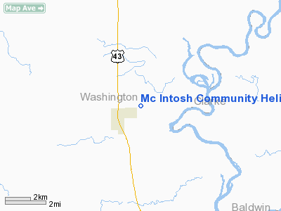
Location
& QuickFacts
|
FAA Information Effective: |
2007-01-18 |
|
Airport
Identifier: |
AL95 |
|
Airport
Status: |
Operational |
|
Longitude/Latitude: |
088-00-45.0020W/31-16-24.6130N
-88.012501/31.273504 (Estimated) |
|
Elevation: |
50
ft / 15.24 m (Estimated) |
|
Land: |
4
acres |
|
From
nearest city: |
1 nautical miles E of Mc Intosh, AL |
|
Location: |
Washington County, AL |
|
Magnetic Variation: |
01E (1990) |
Owner
& Manager
|
Ownership: |
Privately owned |
|
Owner: |
Ciba Geigy Corp. |
|
Address: |
Po Box 113
Mc Intosh, AL 36553-0113 |
|
Phone
number: |
205-944-2201 |
|
Manager: |
L. G. Buffkin |
|
Address: |
Po Box 113
Mc Intosh, AL 36553-0113 |
|
Phone number: |
205-944-2201
EXT. 3200. |
Airport
Operations and Facilities
|
Airport Use: |
Private
EMERGENCY USE ONLY. |
|
Wind
indicator: |
Yes |
|
Segmented
Circle: |
No |
|
Control
Tower: |
No |
|
Lighting
Schedule: |
RDO-CTL
ACTVT ROTG BCN; PERIMETER LGTS; NSTD APCH PATH INDICATOR;
AND WINDSOCK - 122.8. |
|
Beacon Color: |
Clear-Green-Yellow (heliport) |
|
Sectional chart: |
New Orleans |
|
Region: |
ASO - Southern |
|
Boundary ARTCC: |
ZHU - Houston |
|
Tie-in FSS: |
ANB - Anniston |
|
FSS Toll Free: |
1-800-WX-BRIEF |
Airport
Communications
|
Runway Information
Helipad H1
|
Dimension: |
50 x 50 ft / 15.2 x 15.2 m |
|
Surface: |
CONC, |
|
|
Runway H1 |
Runway |
|
Traffic
Pattern: |
Left |
Left |
|
Helipad H2
|
Dimension: |
50 x 50 ft / 15.2 x 15.2 m |
|
Surface: |
CONC, |
|
|
Runway H2 |
Runway |
|
Traffic
Pattern: |
Left |
Left |
|
Radio Navigation
Aids
|
ID |
Type |
Name |
Ch |
Freq |
Var |
Dist |
|
MO |
NDB |
Wisle |
|
248.00 |
02E |
34.3 nm |
|
ESU |
NDB |
Summerdale |
|
204.00 |
01E |
48.8 nm |
|
GCV |
VORTAC |
Greene County |
104X |
115.70 |
05E |
26.5 nm |
|
MVC |
VORTAC |
Monroeville |
115X |
116.80 |
04E |
35.7 nm |
|
SJI |
VORTAC |
Semmes |
100X |
115.30 |
05E |
37.4 nm |
|
BFM |
VORTAC |
Brookley |
075X |
112.80 |
04E |
39.8 nm |
Remarks
- (E111-2)
NO OPNS ARE CONDUCTED WITH A TAILWIND COMPONENT IN EXCESS OF 10 KTS;
THE PINE TREES NW OF HELIPAD ARE CUT DOWN.
- ALL
APCH/DEP RTE OPNS ARE CONDUCTED 250 DEG CLKWS TO 270 DEG USING TD PAD
AS CNTR OF A COMPASS ROSE; THE TD LDG AREA IS APROPLY MKD; A NON-OBSTRUCTING
WIND INDICATOR IS MAINTD ADJ TO THE LDG/TKOF AREA;
Mc Intosh Community Heliport
Address:
Washington County, AL
Tel:
205-944-2201
Images
and information placed above are from
http://www.airport-data.com/airport/AL95/
We
thank them for the data!
| General
Info |
| Country |
United
States |
| State |
ALABAMA
|
| FAA ID |
AL95
|
| Latitude |
31-16-24.613N
|
| Longitude |
088-00-45.002W
|
| Elevation |
50 feet
|
| Near City |
MC INTOSH
|
We don't guarantee the information is fresh and accurate. The data may
be wrong or outdated.
For more up-to-date information please refer to other sources.
|
|


