 |
|
Madison County Executive Airport |
Madison County Executive Airport
Tom Sharp Jr. Field |
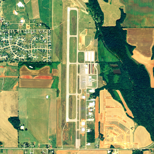 |
| NAIP aerial image, 2006 |
| IATA: none â ICAO: KMDQ â FAA LID: MDQ |
| Summary |
| Airport type |
Public |
| Owner |
Madison County Executive Airport Authority |
| Serves |
Huntsville, Alabama |
| Elevation AMSL |
756 ft / 230 m |
| Coordinates |
34°51â²41â³N 086°33â²27â³W / 34.86139°N 86.5575°W / 34.86139; -86.5575 |
| Website |
www.MCEAA.org |
| Runways |
| Direction |
Length |
Surface |
| ft |
m |
| 18/36 |
5,008 |
1,526 |
Asphalt |
| Statistics (2009) |
| Aircraft operations |
34,260 |
| Based aircraft |
102 |
| Sources: FAA, airport web site |
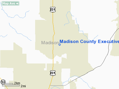
Madison County Executive Airport (ICAO: KMDQ, FAA LID: MDQ, formerly M82), also known as Tom Sharp Jr. Field, is a public-use airport in Madison County, Alabama, United States. It is owned by the Madison County Executive Airport Authority and located one nautical mile (1.85 km) northeast of the central business district of Huntsville. According to the FAA's National Plan of Integrated Airport Systems for 2009â2013, it is categorized as a general aviation facility.
Although most U.S. airports use the same three-letter location identifier for the FAA and IATA, Madison County Executive Airport is assigned MDQ by the FAA but has no designation from the IATA (which assigned MDQ to Mar del Plata, Argentina).
Facilities and aircraft
The airport covers an area of 485 acres (196 ha) at an elevation of 756 feet (230 m) above mean sea level. It has one runway designated 18/36 with an asphalt surface measuring 5,008 by 100 feet (1,526 x 30 m).
For the 12-month period ending April 16, 2009, the airport had 34,260 aircraft operations, an average of 93 per day: 93% general aviation, 5% air taxi, and 2% military. At that time there were 102 aircraft based at this airport: 82% single-engine, 9% multi-engine, 2% jet and 67% helicopter.
The above content comes from Wikipedia and is published under free licenses – click here to read more.
Location
& QuickFacts
|
FAA Information Effective: |
2007-01-18 |
|
Airport
Identifier: |
MDQ |
|
Airport
Status: |
Operational |
|
Longitude/Latitude: |
086-33-26.9000W/34-51-41.1000N
-86.557472/34.861417 (Estimated) |
|
Elevation: |
756 ft / 230.43 m (Surveyed) |
|
Land: |
485 acres |
|
From
nearest city: |
1 nautical miles NE of Huntsville, AL |
|
Location: |
Madison County, AL |
|
Magnetic Variation: |
02W (2000) |
Owner
& Manager
|
Ownership: |
Publicly owned |
|
Owner: |
Madison Co Exec Arpt Auth
TOM SHARP CHAIRMAN. |
|
Address: |
Po Box 110
Meridianville, AL 35759 |
|
Phone
number: |
256-828-3883 |
|
Manager: |
Ray Meyer |
|
Address: |
358 Bolling Rd
Meridianville, AL 35759 |
|
Phone number: |
256-828-3883 |
Airport
Operations and Facilities
|
Airport Use: |
Open to public |
|
Wind
indicator: |
Yes |
|
Segmented
Circle: |
Yes |
|
Control
Tower: |
No |
|
Lighting
Schedule: |
DUSK-DAWN
ACTVT MIRL RY 18/36, REILS RY 18, 36 - CTAF. |
|
Beacon
Color: |
Clear-Green (lighted land airport) |
|
Landing
fee charge: |
No |
|
Sectional
chart: |
Atlanta |
|
Region: |
ASO - Southern |
|
Boundary
ARTCC: |
ZME - Memphis |
|
Tie-in
FSS: |
ANB - Anniston |
|
FSS
on Airport: |
No |
|
FSS
Toll Free: |
1-800-WX-BRIEF |
|
NOTAMs
Facility: |
MDQ (NOTAM-d service avaliable) |
|
Federal Agreements: |
NGY |
Airport
Communications
|
CTAF: |
123.000 |
|
Unicom: |
123.000 |
Airport
Services
|
Fuel available: |
100LLA MOGAS |
|
Airframe Repair: |
MAJOR |
|
Power Plant Repair: |
MAJOR |
|
Bottled
Oxygen: |
NONE |
|
Bulk
Oxygen: |
NONE |
|
Runway Information
Runway 18/36
|
Dimension: |
5008 x 100 ft / 1526.4 x 30.5 m |
|
Surface: |
ASPH, Good Condition |
|
Weight
Limit: |
Single wheel: 60000 lbs.
Dual wheel: 75000 lbs.
Dual
tandem wheel: 140000 lbs. |
|
Edge
Lights: |
Medium |
|
|
Runway 18 |
Runway 36 |
|
Longitude: |
086-33-26.4184W |
086-33-27.3945W |
|
Latitude: |
34-52-05.8092N |
34-51-16.3175N |
|
Elevation: |
719.00
ft |
756.00
ft |
|
Alignment: |
127 |
1 |
|
Traffic
Pattern: |
Left |
Right |
|
Markings: |
Precision instrument, Good Condition |
Precision instrument, Good Condition |
|
Crossing
Height: |
40.00
ft |
40.00
ft |
|
VASI: |
4-light PAPI on left side |
4-light PAPI on left side |
|
Visual
Glide Angle: |
3.00° |
3.00° |
|
Runway
End Identifier: |
Yes |
Yes |
|
Touchdown
Lights: |
|
No |
|
Radio Navigation
Aids
|
ID |
Type |
Name |
Ch |
Freq |
Var |
Dist |
|
SYI |
FAN MARKER |
Bomar |
|
|
01W |
37.7 nm |
|
HUA |
NDB |
Redstone |
|
287.00 |
00W |
11.7 nm |
|
CWH |
NDB |
Capshaw |
|
350.00 |
01W |
12.1 nm |
|
TNY |
NDB |
Kelso |
|
358.00 |
01W |
16.4 nm |
|
GZS |
NDB |
Giles/dcmsnd |
|
375.00 |
00E |
30.2 nm |
|
BGF |
NDB |
Boiling Fork |
|
263.00 |
02W |
30.7 nm |
|
CPP |
NDB |
Cole Spring |
|
230.00 |
01W |
32.5 nm |
|
UOS |
NDB |
Sewanee |
|
275.00 |
02E |
38.5 nm |
|
ULH |
NDB |
Burwi |
|
332.00 |
03W |
39.3 nm |
|
ARF |
NDB |
Saratoga |
|
296.00 |
02W |
40.1 nm |
|
LUG |
NDB |
Verona |
|
251.00 |
00W |
40.4 nm |
|
LRT |
NDB |
Lawrenceburg |
|
269.00 |
00E |
41.3 nm |
|
FTP |
NDB |
Fort Payne |
|
426.00 |
01W |
48.2 nm |
|
APT |
NDB |
Jasper |
|
382.00 |
02W |
49.4 nm |
|
UXM |
VOR |
Tullahoma Regional |
|
109.65 |
03W |
34.8 nm |
|
DCU |
VOR/DME |
Decatur |
075X |
112.80 |
01W |
22.8 nm |
|
SYI |
VOR/DME |
Shelbyville |
027X |
109.00 |
01W |
42.5 nm |
|
RQZ |
VORTAC |
Rocket |
059X |
112.20 |
02E |
5.4 nm |
|
MSL |
VORTAC |
Muscle Shoals |
112X |
116.50 |
01E |
47.0 nm |
|
HSV |
VOT |
Huntsville |
|
111.00 |
|
12.8 nm |
Remarks
- GCO
AVBL ON FREQ 121.725 THRU HSV APCH & ANB FSS.
Based Aircraft
|
Aircraft
based on field: |
57 |
|
Single
Engine Airplanes: |
54 |
|
Multi
Engine Airplanes: |
2 |
|
Helicopters: |
1 |
Operational Statistics
Time Period: 1999-08-26
- 2000-08-24
|
Aircraft
Operations: |
89/Day |
|
General
Aviation Local: |
12.4% |
|
General
Aviation Itinerant: |
87.6% |
Madison County Executive Airport
Address:
Madison County, AL
Tel:
256-828-3883
Images
and information placed above are from
http://www.airport-data.com/airport/MDQ/
We
thank them for the data!
| General
Info |
| Country |
United
States |
| State |
ALABAMA
|
| FAA ID |
MDQ
|
| Latitude |
34-51-41.070N
|
| Longitude |
086-33-26.900W
|
| Elevation |
755 feet
|
| Near City |
HUNTSVILLE
|
We don't guarantee the information is fresh and accurate. The data may
be wrong or outdated.
For more up-to-date information please refer to other sources.
|
|


