 |
|
- This article refers to an airport in Samson, Alabama. For the Logan airport in Massachusetts (Boston area), see Logan International Airport
Logan Field
Samson Municipal Airport |
 |
| IATA: none â ICAO: none â FAA LID: 1A4 |
| Summary |
| Airport type |
Public |
| Owner |
City of Samson |
| Serves |
Samson, Alabama |
| Elevation AMSL |
200 ft / 61 m |
| Coordinates |
31°06â²10â³N 086°03â²44â³W / 31.10278°N 86.06222°W / 31.10278; -86.06222 |
| Runways |
| Direction |
Length |
Surface |
| ft |
m |
| 5/23 |
3,256 |
992 |
Asphalt |
| Source: Federal Aviation Administration |
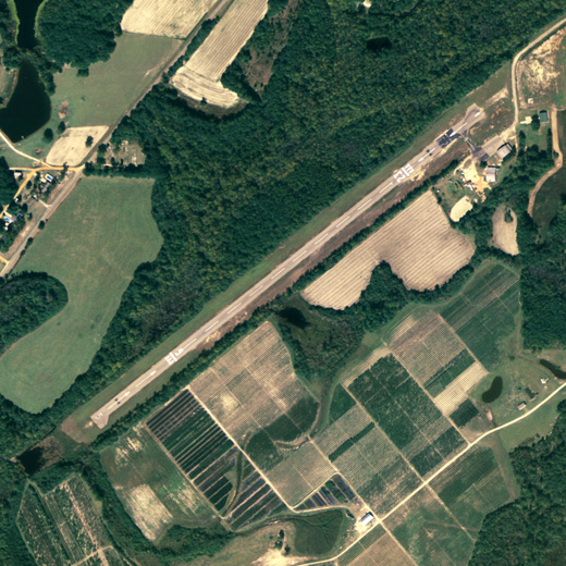
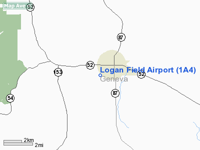
Logan Field (FAA LID: 1A4), also known as Samson Municipal Airport, is a city-owned, public-use airport located one nautical mile (2 km) southwest of the central business district of Samson, a city in Geneva County, Alabama, United States.
Facilities
Logan Field has one asphalt paved runway designated 5/23 which meassures 3,256 by 75 feet (992 by 23 m).
The above content comes from Wikipedia and is published under free licenses – click here to read more.
Location
& QuickFacts
|
FAA Information Effective: |
2007-01-18 |
|
Airport
Identifier: |
1A4 |
|
Airport
Status: |
Operational |
|
Longitude/Latitude: |
086-03-44.0000W/31-06-10.0000N
-86.062222/31.102778 (Estimated) |
|
Elevation: |
200 ft / 60.96 m (Estimated) |
|
Land: |
0
acres |
|
From
nearest city: |
1 nautical miles SW of Samson, AL |
|
Location: |
Geneva County, AL |
|
Magnetic Variation: |
() |
Owner
& Manager
|
Ownership: |
Publicly owned |
|
Owner: |
City Of Samson |
|
Address: |
104 E Main Street
Samson, AL 36477 |
|
Phone
number: |
334-898-7541 |
|
Manager: |
Randy S. Goodwin |
|
Address: |
420 S. Canal Street
Samson, AL 36477 |
|
Phone number: |
334-898-2682
CELL PHONE 334-303-9050. |
Airport
Operations and Facilities
|
Airport Use: |
Open to public |
|
Segmented Circle: |
No |
|
Control Tower: |
No |
|
Sectional chart: |
New Orleans |
|
Region: |
ASO - Southern |
|
Boundary ARTCC: |
ZJX - Jacksonville |
|
Responsible ARTCC: |
ZJX - Jacksonville |
|
Tie-in FSS: |
ANB - Anniston |
|
FSS Toll Free: |
1-800-WX-BRIEF |
Airport
Services
|
Airframe Repair: |
MINOR |
|
Power Plant Repair: |
MINOR |
|
Runway Information
Runway 05/23
|
Dimension: |
3256 x 75 ft / 992.4 x 22.9 m |
|
Surface: |
ASPH, Poor Condition
SURFACE VERY ROUGH, WEATHERED, RAVELED, LOOSE AGGREGATE. |
|
Edge
Lights: |
Low
LIRL OTS INDEFLY. |
|
|
Runway 05 |
Runway 23 |
|
Traffic
Pattern: |
Left |
Left |
|
Markings: |
Basic, Good Condition |
Basic, Good Condition |
|
Displaced
threshold: |
722.00 ft
HAS 19:1 SLOPE TO DSPLCD THLD. |
693.00 ft
HAS 23:1 SLOPE TO DSPLCD THLD. |
|
Obstruction: |
80 ft trees, 868.0 ft from runway, 204 ft left
of centerline, 8:1 slope to clear |
72 ft trees, 1011.0 ft from runway, 11:1 slope
to clear |
|
Radio Navigation
Aids
|
ID |
Type |
Name |
Ch |
Freq |
Var |
Dist |
|
BVG |
NDB |
Boll Weevil |
|
352.00 |
03E |
14.6 nm |
|
OZ |
NDB |
Ruckr |
|
212.00 |
00E |
14.7 nm |
|
JUY |
NDB |
Judd |
|
264.00 |
02W |
20.8 nm |
|
LOR |
NDB |
Lowe |
|
269.00 |
03W |
22.5 nm |
|
HYE |
NDB |
Hanchey |
|
221.00 |
00E |
26.5 nm |
|
BKK |
NDB |
Tri County |
|
275.00 |
02W |
28.1 nm |
|
XBR |
NDB |
Brantley |
|
410.00 |
00E |
30.0 nm |
|
XNE |
NDB |
Spring Hill |
|
281.00 |
00E |
35.2 nm |
|
TO |
NDB |
Blood |
|
365.00 |
01W |
43.8 nm |
|
SMY |
NDB |
Soyya |
|
329.00 |
02W |
45.3 nm |
|
DTS |
NDB |
Destin |
|
254.00 |
01W |
47.0 nm |
|
DWG |
TACAN |
Warrington |
002X |
|
00E |
44.4 nm |
|
EDN |
VOR |
Enterprise |
|
116.60 |
03W |
14.2 nm |
|
UIA |
VOR |
Andalusia |
|
110.20 |
00E |
21.0 nm |
|
HEY |
VOR |
Hanchey |
|
110.60 |
02E |
26.6 nm |
|
FYL |
VOR |
Tri County |
|
108.40 |
08W |
28.2 nm |
|
OZR |
VOR/DME |
Cairns |
049X |
111.20 |
02E |
20.0 nm |
|
RRS |
VORTAC |
Wiregrass |
053X |
111.60 |
02E |
34.2 nm |
|
CEW |
VORTAC |
Crestview |
106X |
115.90 |
03E |
35.9 nm |
Based
Aircraft
|
Aircraft
based on field: |
4 |
|
Single
Engine Airplanes: |
4 |
Logan Field Airport
Address:
Geneva County, AL
Tel:
334-898-7541,
334-898-2682
Images
and information placed above are from
http://www.airport-data.com/airport/1A4/
We
thank them for the data!
| General
Info |
| Country |
United
States |
| State |
ALABAMA
|
| FAA ID |
1A4
|
| Latitude |
31.102778
31° 06' 10.00" N |
| Longitude |
-86.062222
086° 03' 44.00" W |
| Elevation |
200 feet
61 meters |
| Magnetic
Variation |
002° W
(08/06) |
| Operating
Agency |
MUNICIPAL
|
We don't guarantee the information is fresh and accurate. The data may
be wrong or outdated.
For more up-to-date information please refer to other sources.
|
|


