 |
|
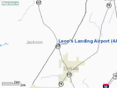
Location
& QuickFacts
|
FAA Information Effective: |
2007-01-18 |
|
Airport
Identifier: |
4AL7 |
|
Airport
Status: |
Operational |
|
Longitude/Latitude: |
085-41-23.4000W/34-44-41.0000N
-85.689833/34.744722 (Estimated) |
|
Elevation: |
1430 ft / 435.86 m (Estimated) |
|
Land: |
0
acres |
|
From
nearest city: |
4 nautical miles SE of Flat Rock, AL |
|
Location: |
Jackson County, AL |
|
Magnetic Variation: |
03W (2000) |
Owner
& Manager
|
Ownership: |
Privately owned |
|
Owner: |
Leon Wilks |
|
Address: |
23354 Alabama Hwy 117
Flat Rock, AL 35966 |
|
Phone
number: |
256-632-3570 |
|
Manager: |
Leon Wilks |
|
Address: |
23354 Alabama Hwy 117
Flat Rock, AL 35966 |
|
Phone number: |
256-632-3570 |
Airport
Operations and Facilities
|
Airport Use: |
Private |
|
Segmented
Circle: |
No |
|
Control
Tower: |
No |
|
Sectional
chart: |
Atlanta |
|
Region: |
ASO - Southern |
|
Boundary
ARTCC: |
ZTL - Atlanta |
|
Tie-in
FSS: |
ANB - Anniston |
|
FSS
Toll Free: |
1-800-WX-BRIEF |
|
Runway Information
Runway 16/34
|
Dimension: |
3000 x 100 ft / 914.4 x 30.5 m |
|
Surface: |
TURF, |
|
|
Runway 16 |
Runway 34 |
|
Traffic
Pattern: |
Left |
Left |
|
Obstruction: |
30 ft trees, 625.0 ft from runway |
20 ft pline, 550.0 ft from runway |
|
Radio Navigation
Aids
|
ID |
Type |
Name |
Ch |
Freq |
Var |
Dist |
|
FTP |
NDB |
Fort Payne |
|
426.00 |
01W |
13.5 nm |
|
APT |
NDB |
Jasper |
|
382.00 |
02W |
19.6 nm |
|
UOS |
NDB |
Sewanee |
|
275.00 |
02E |
29.4 nm |
|
BGF |
NDB |
Boiling Fork |
|
263.00 |
02W |
32.0 nm |
|
CQN |
NDB |
Daisy |
|
341.00 |
02W |
36.5 nm |
|
UWI |
NDB |
Whitfield |
|
400.00 |
03W |
36.8 nm |
|
OYD |
NDB |
Floyd |
|
388.00 |
02W |
37.4 nm |
|
ARF |
NDB |
Saratoga |
|
296.00 |
02W |
39.7 nm |
|
OUK |
NDB |
Calhoun |
|
323.00 |
02W |
43.0 nm |
|
HDI |
NDB |
Hardwick |
|
369.00 |
01W |
45.8 nm |
|
TNY |
NDB |
Kelso |
|
358.00 |
01W |
48.1 nm |
|
HUA |
NDB |
Redstone |
|
287.00 |
00W |
49.4 nm |
|
UXM |
VOR |
Tullahoma Regional |
|
109.65 |
03W |
47.0 nm |
|
GQO |
VORTAC |
Choo Choo |
105X |
115.80 |
01E |
29.5 nm |
|
RMG |
VORTAC |
Rome |
101X |
115.40 |
01E |
45.0 nm |
|
RQZ |
VORTAC |
Rocket |
059X |
112.20 |
02E |
46.7 nm |
Remarks
Based
Aircraft
|
Aircraft
based on field: |
1 |
|
Single
Engine Airplanes: |
1 |
Leon's Landing Airport
Address:
Jackson County, AL
Tel:
256-632-3570
Images
and information placed above are from
http://www.airport-data.com/airport/4AL7/
We
thank them for the data!
| General
Info |
| Country |
United
States |
| State |
ALABAMA
|
| FAA ID |
4AL7
|
| Latitude |
34-44-41.000N
|
| Longitude |
085-41-23.400W
|
| Elevation |
1430 feet
|
| Near City |
FLAT ROCK
|
We don't guarantee the information is fresh and accurate. The data may
be wrong or outdated.
For more up-to-date information please refer to other sources.
|
|


