 |
|
| Lanett Municipal Airport |
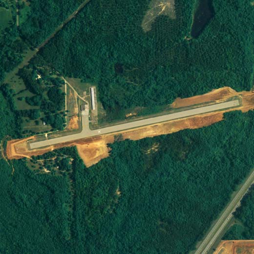 |
| NAIP aerial image, 2006 |
| IATA: none â ICAO: none â FAA LID: 7A3 |
| Summary |
| Airport type |
Public |
| Owner |
City of Lanett |
| Serves |
Lanett, Alabama |
| Elevation AMSL |
624 ft / 190 m |
| Coordinates |
32°48â²43â³N 085°13â²46â³W / 32.81194°N 85.22944°W / 32.81194; -85.22944 |
| Runways |
| Direction |
Length |
Surface |
| ft |
m |
| 8/26 |
3,148 |
960 |
Asphalt |
| Statistics (2010) |
| Aircraft operations |
3,290 |
| Based aircraft |
13 |
| Source: Federal Aviation Administration |
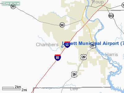
Lanett Municipal Airport (FAA LID: 7A3) is a city-owned public-use airport located three nautical miles (6 km) southwest of the central business district of Lanett, a city in Chambers County, Alabama, United States. According to the FAA's National Plan of Integrated Airport Systems for 2009â2013, it is categorized as a general aviation facility.
Facilities and aircraft
Lanett Municipal Airport covers an area of 150 acres (61 ha) at an elevation of 624 feet (190 m) above mean sea level. It has one runway designated 8/26 with an asphalt surface measuring 3,148 by 80 feet (960 x 24 m).
For the 12-month period ending February 24, 2010, the airport had 3,290 aircraft operations, an average of 274 per month: 99.7% general aviation and 0.3% military. At that time there were 13 aircraft based at this airport: 84.6% single-engine, 7.7% multi-engine and 7.7% ultralight.
The above content comes from Wikipedia and is published under free licenses – click here to read more.
Location
& QuickFacts
|
FAA Information Effective: |
2007-01-18 |
|
Airport
Identifier: |
7A3 |
|
Airport
Status: |
Operational |
|
Longitude/Latitude: |
085-13-46.4920W/32-48-43.3660N
-85.229581/32.812046 (Estimated) |
|
Elevation: |
624 ft / 190.20 m (Surveyed) |
|
Land: |
150 acres |
|
From
nearest city: |
3 nautical miles SW of Lanett, AL |
|
Location: |
Chambers County, AL |
|
Magnetic Variation: |
01W (1985) |
Owner
& Manager
|
Ownership: |
Publicly owned |
|
Owner: |
City Of Lanett |
|
Address: |
Po Box 290
Lanett, AL 36863 |
|
Phone
number: |
334-644-2141 |
|
Manager: |
Fred Johnson |
|
Address: |
4445 51st Ave Sw, Po Box 322
Lanett, AL 36863 |
|
Phone number: |
334-576-6998 |
Airport
Operations and Facilities
|
Airport Use: |
Open to public |
|
Wind
indicator: |
Yes |
|
Segmented
Circle: |
No |
|
Control
Tower: |
No |
|
Lighting
Schedule: |
DUSK-DAWN |
|
Beacon
Color: |
Clear-Green (lighted land airport) |
|
Landing
fee charge: |
No |
|
Sectional
chart: |
Atlanta |
|
Region: |
ASO - Southern |
|
Boundary
ARTCC: |
ZTL - Atlanta |
|
Tie-in
FSS: |
ANB - Anniston |
|
FSS
on Airport: |
No |
|
FSS
Toll Free: |
1-800-WX-BRIEF |
|
NOTAMs
Facility: |
ANB (NOTAM-d service avaliable) |
|
Federal Agreements: |
N |
Airport
Communications
|
CTAF: |
122.800 |
|
Unicom: |
122.800 |
Airport
Services
|
Fuel available: |
100LL |
|
Airframe Repair: |
MAJOR |
|
Power Plant Repair: |
MINOR |
|
Bottled
Oxygen: |
NONE |
|
Bulk
Oxygen: |
NONE |
|
Runway Information
Runway 08/26
|
Dimension: |
3148 x 80 ft / 959.5 x 24.4 m |
|
Surface: |
ASPH, Poor Condition
RY 08/26 SFC CRACKED, LOOSE AGGREGATE. |
|
Weight
Limit: |
Single wheel: 16000 lbs. |
|
Edge
Lights: |
Medium |
|
|
Runway 08 |
Runway 26 |
|
Longitude: |
085-14-04.6590W |
085-13-28.3880W |
|
Latitude: |
32-48-40.4170N |
32-48-46.3300N |
|
Elevation: |
618.00
ft |
624.00
ft |
|
Alignment: |
79 |
127 |
|
Traffic
Pattern: |
Left |
Left |
|
Markings: |
Basic, Poor Condition
RY 08/26 MARKINGS FADED. |
Basic, Poor Condition |
|
Obstruction: |
62 ft trees, 818.0 ft from runway, 165 ft left
of centerline, 9:1 slope to clear
RY 08 HAS +20 FT TREES 0-80 FT FROM THLD & 80 FT L AND
+10 FT BRUSH 55 FT FROM THLD & 85 FT R. |
42 ft tree, 336.0 ft from runway, 122 ft left
of centerline, 3:1 slope to clear
RY 26 HAS +15 FT TREES 0-70 FT FROM THLD & 90 FT L AND
+5 FT BRUSH 75 FT FROM THLD & 100 FT R. |
|
Radio Navigation
Aids
|
ID |
Type |
Name |
Ch |
Freq |
Var |
Dist |
|
PIM |
NDB |
Pine Mountain |
|
272.00 |
03W |
18.1 nm |
|
AWS |
NDB |
Lawson |
|
335.00 |
02W |
32.9 nm |
|
DER |
NDB |
Alexander City |
|
382.00 |
01W |
37.2 nm |
|
EQQ |
NDB |
Coweta County |
|
234.00 |
03W |
37.3 nm |
|
GPQ |
NDB |
Carrollton |
|
278.00 |
02W |
45.6 nm |
|
FF |
NDB |
Pecat |
|
316.00 |
02W |
47.6 nm |
|
TGE |
VOR/DME |
Tuskegee |
120X |
117.30 |
02E |
29.7 nm |
|
LSF |
VOR/DME |
Lawson |
051X |
111.40 |
02W |
31.2 nm |
|
LGC |
VORTAC |
Lagrange |
103X |
115.60 |
01E |
14.3 nm |
|
CSG |
VORTAC |
Columbus |
118X |
117.10 |
01E |
16.0 nm |
Remarks
- DEER
ON & INVOF ARPT.
- BUILT
PRIOR TO FAA ACT.
Based
Aircraft
|
Aircraft
based on field: |
14 |
|
Single
Engine Airplanes: |
11 |
|
Multi
Engine Airplanes: |
2 |
|
Ultralights: |
1 |
Operational Statistics
Time Period: 1998-10-20
- 1999-10-19
|
Aircraft
Operations: |
64/Week |
|
General
Aviation Local: |
28.6% |
|
General
Aviation Itinerant: |
71.1% |
|
Military: |
0.3% |
Lanett Municipal Airport
Address:
Chambers County, AL
Tel:
334-644-2141,
334-576-6998
Images
and information placed above are from
http://www.airport-data.com/airport/7A3/
We
thank them for the data!
| General
Info |
| Country |
United
States |
| State |
ALABAMA
|
| FAA ID |
7A3
|
| Time |
UTC-6(-5DT)
|
| Latitude |
32.812047
32° 48' 43.37" N |
| Longitude |
-85.229581
085° 13' 46.49" W |
| Elevation |
624 feet
190 meters |
| Type |
Civil
|
| Magnetic
Variation |
003° W
(01/06) |
| Beacon |
Yes
|
| Operating
Agency |
MUNICIPAL
|
| Operating
Hours |
SEE REMARKS
FOR OPERATING HOURS OR COMMUNICATIONS FOR POSSIBLE HOURS |
| Daylight
Saving Time |
Second
Sunday in March at 0200 to first Sunday in November at 0200 local
time (Exception Arizona and that portion of Indiana in the Eastern
Time Zone) |
We don't guarantee the information is fresh and accurate. The data may
be wrong or outdated.
For more up-to-date information please refer to other sources.
|
|


