 |
|
Jackson Municipal Airport |
| Jackson Municipal Airport |
 |
| IATA: none – ICAO: none – FAA LID: 4R3 |
| Summary |
| Airport type |
Public |
| Owner |
Jackson, Alabama |
| Serves |
Jackson, Alabama |
| Elevation AMSL |
39 ft / 12 m |
| Coordinates |
31°28′14″N 087°53′45″W / 31.47056°N 87.89583°W / 31.47056; -87.89583 |
| Runways |
| Direction |
Length |
Surface |
| ft |
m |
| 1/19 |
5,003 |
1,525 |
Asphalt |
| Statistics (2007) |
| Aircraft operations |
2,800 |
| Source: Federal Aviation Administration |
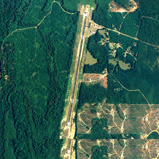
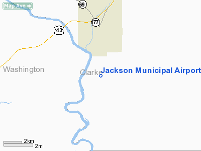
Jackson Municipal Airport (FAA LID: 4R3) is a city-owned public-use airport located 2 nautical miles (4 km) south of the central business district of Jackson, a city in Clarke County, Alabama, United States.
Facilities and aircraft
Jackson Municipal Airport covers an area of 112 acres (0.17 sq mi; 0.45 km), and contains one runway designated 1/19 that is 5,003 x 75 feet (1,525 x 23 meters) with asphalt pavement. For the 12-month period ending July 25, 2007, the airport had 2,800 general aviation aircraft operations.
The above content comes from Wikipedia and is published under free licenses – click here to read more.
Location
& QuickFacts
|
FAA Information Effective: |
2007-01-18 |
|
Airport
Identifier: |
4R3 |
|
Airport
Status: |
Operational |
|
Longitude/Latitude: |
087-53-40.9950W/31-28-19.5910N
-87.894721/31.472109 (Estimated) |
|
Elevation: |
39
ft / 11.89 m (Estimated) |
|
Land: |
112 acres |
|
From
nearest city: |
2 nautical miles S of Jackson, AL |
|
Location: |
Clarke County, AL |
|
Magnetic Variation: |
01E (1985) |
Owner
& Manager
|
Ownership: |
Publicly owned |
|
Owner: |
City Of Jackson |
|
Address: |
Po Box 1096
Jackson, AL 36545 |
|
Phone number: |
334-246-2461 |
|
Manager: |
Brenda Coleman |
|
Address: |
Po Box 1011
Jackson, AL 36546 |
|
Phone number: |
334-246-2304 |
Airport
Operations and Facilities
|
Airport Use: |
Open to public |
|
Wind
indicator: |
Yes
TETRAHYDRON. |
|
Segmented
Circle: |
No |
|
Control
Tower: |
No |
|
Lighting
Schedule: |
DUSK-DAWN |
|
Beacon
Color: |
Clear-Green (lighted land airport)
BCN OBSCURED BY TREES TO THE EAST. |
|
Landing
fee charge: |
No |
|
Sectional
chart: |
New Orleans |
|
Region: |
ASO - Southern |
|
Boundary
ARTCC: |
ZHU - Houston |
|
Tie-in
FSS: |
ANB - Anniston |
|
FSS
on Airport: |
No |
|
FSS
Toll Free: |
1-800-WX-BRIEF |
|
NOTAMs
Facility: |
ANB (NOTAM-d service avaliable) |
|
Federal Agreements: |
NY1 |
Airport
Communications
Airport
Services
|
Fuel available: |
100LL |
|
Airframe Repair: |
NONE |
|
Power Plant Repair: |
NONE |
|
Bottled
Oxygen: |
NONE |
|
Bulk
Oxygen: |
NONE |
|
Runway Information
Runway 18/36
|
Dimension: |
4995 x 75 ft / 1522.5 x 22.9 m |
|
Surface: |
ASPH, Good Condition |
|
Weight
Limit: |
Single wheel: 25000 lbs. |
|
Edge
Lights: |
Medium |
|
|
Runway 18 |
Runway 36 |
|
Traffic
Pattern: |
Left |
Left |
|
Markings: |
Basic, Good Condition |
Basic, Good Condition |
|
VASI: |
pulsating/steady burning on left side |
pulsating/steady burning on left side |
|
Obstruction: |
28 ft trees, 486.0 ft from runway, 10:1 slope
to clear |
93 ft trees, 1580.0 ft from runway, 125 ft
left of centerline, 14:1 slope to clear |
|
Radio Navigation
Aids
|
ID |
Type |
Name |
Ch |
Freq |
Var |
Dist |
|
BCZ |
NDB |
Choctaw |
|
228.00 |
01E |
40.3 nm |
|
MO |
NDB |
Wisle |
|
248.00 |
02E |
47.7 nm |
|
MVC |
VORTAC |
Monroeville |
115X |
116.80 |
04E |
27.8 nm |
|
GCV |
VORTAC |
Greene County |
104X |
115.70 |
05E |
37.8 nm |
Remarks
- RY
18/36 SLOPES UPHILL TO THE SOUTH.
- OTS
INDEFLY.
- VFR
OPERNS ONLY.
Based
Aircraft
|
Aircraft
based on field: |
4 |
|
Single
Engine Airplanes: |
3 |
|
Multi
Engine Airplanes: |
1 |
Operational Statistics
Time Period: 1999-02-22
- 2000-02-21
|
Aircraft
Operations: |
54/Week |
|
General
Aviation Local: |
21.4% |
|
General
Aviation Itinerant: |
78.6% |
Jackson Municipal Airport
Address:
Clarke County, AL
Tel:
334-246-2461, 334-246-2304
Images
and information placed above are from
http://www.airport-data.com/airport/4R3/
We
thank them for the data!
| General
Info |
| Country |
United
States |
| State |
ALABAMA
|
| FAA ID |
4R3
|
| Latitude |
31-28-19.591N
|
| Longitude |
087-53-40.995W
|
| Elevation |
39 feet
|
| Near City |
JACKSON
|
We don't guarantee the information is fresh and accurate. The data may
be wrong or outdated.
For more up-to-date information please refer to other sources.
|
|


