|
|
Coordinates: 30°17â²23â³N 087°40â²18â³W / 30.28972°N 87.67167°W / 30.28972; -87.67167
| Jack Edwards Airport {www.jka.us.com} |
 |
| IATA: GUF â ICAO: KJKA â FAA LID: JKA |
| Summary |
| Airport type |
Public |
| Owner |
City of Gulf Shores |
| Location |
Gulf Shores, Alabama |
| Elevation AMSL |
17 ft / 5 m |
| Runways |
| Direction |
Length |
Surface |
| ft |
m |
| 9/27 |
6,962 |
2,122 |
Asphalt |
| 17/35 |
3,596 |
1,096 |
Asphalt |
| Statistics (2006) |
| Aircraft operations |
95,501 |
| Based aircraft |
133 |
| Source: Federal Aviation Administration |
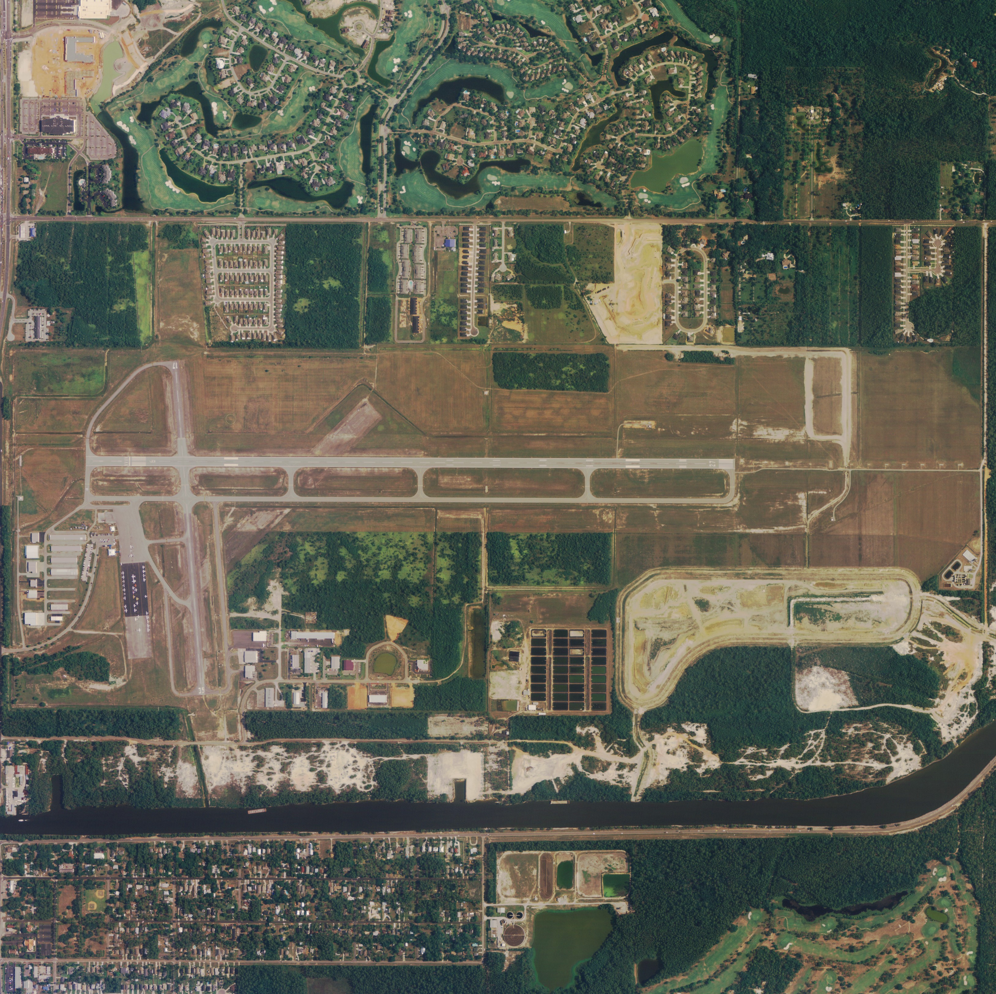
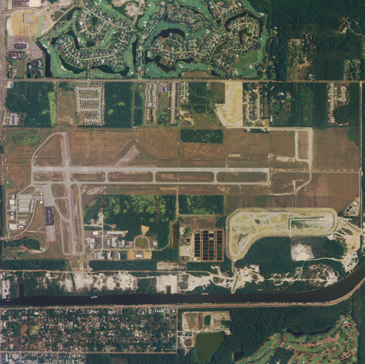
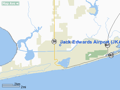
Jack Edwards Airport (IATA: GUF, ICAO: KJKA, FAA LID: JKA, formerly AL15) is a general aviation airport located two miles (3 km) north of the central business district of Gulf Shores, a city in Baldwin County, Alabama, United States.
Although most U.S. airports use the same three-letter location identifier for the FAA and IATA, Jack Edwards Airport is assigned JKA by the FAA and GUF by the IATA. History
Jack Edwards Airport was originally an outlying field for Naval Air Station Pensacola. The U.S. Navy sold it to the state of Alabama in 1977 and the new airport was named for U.S. Rep. Jack Edwards. In 1983 the state sold the airport to the city of Gulf Shores. A new terminal was built in 1998 and a runway extension was completed in 2003.
Facilities and aircraft
Jack Edwards Airport covers an area of 583 acres (204 ha) which contains two asphalt paved runways: 9/27 measuring 6,962 x 100 ft (2,122 x 30 m) and 17/35 measuring 3,596 x 75 ft (1,096 x 23 m).
For the 12-month period ending March 7, 2010, the airport had 95,501 aircraft operations, an average of 261 per day: 98% general aviation and 2% military. At that time there were 163 aircraft based at this airport: 80% single-engine, 15% multi-engine and 5% jet.
Jack Edwards Airport covers an area of 838 acres which contains two asphalt paved runways: 9/27 measuring 6,962 x 100 ft (2,122 x 30 m) and 17/35 measuring 3,596 x 75 ft (1,096 x 23 m).[1]
Jack Edwards national airport has an average of 83,585 aircraft operations, an average of 229 per day: 98% general aviation and 2% military. At that time there were 163 aircraft based at this airport: 80% single-engine, 15% multi-engine and 5% jet.[1]
The above content comes from Wikipedia and is published under free licenses – click here to read more.
Location
& QuickFacts
|
FAA Information Effective: |
2007-01-18 |
|
Airport
Identifier: |
JKA |
|
Airport
Status: |
Operational |
|
Longitude/Latitude: |
087-40-18.4000W/30-17-22.7000N
-87.671778/30.289639 (Estimated) |
|
Elevation: |
17
ft / 5.18 m (Surveyed) |
|
Land: |
503 acres |
|
From
nearest city: |
2 nautical miles N of Gulf Shores, AL |
|
Location: |
Baldwin County, AL |
|
Magnetic Variation: |
00E (2000) |
Owner
& Manager
|
Ownership: |
Publicly owned |
|
Owner: |
City Of Gulf Shores |
|
Address: |
Po Box 299
Gulf Shores, AL 36547 |
|
Phone
number: |
251-968-2425 |
|
Manager: |
Russ Kilgore |
|
Address: |
Po Box 299
Gulf Shores, AL 36547 |
|
Phone number: |
251-967-3968 |
Airport
Operations and Facilities
|
Airport Use: |
Open to public |
|
Wind
indicator: |
Yes |
|
Segmented
Circle: |
No |
|
Control
Tower: |
No |
|
Lighting
Schedule: |
DUSK-DAWN
HIRL RY 09/27 PRESET MED INTST DUSK-DAWN TO INCR INTST ACTIVATE
HIRL RY 09/27, MALSR RY 27 & PAPI RY 09 & 27 - CTAF. |
|
Beacon
Color: |
Clear-Green (lighted land airport) |
|
Landing
fee charge: |
No |
|
Sectional
chart: |
New Orleans |
|
Region: |
ASO - Southern |
|
Boundary
ARTCC: |
ZJX - Jacksonville |
|
Tie-in
FSS: |
ANB - Anniston |
|
FSS
on Airport: |
No |
|
FSS
Toll Free: |
1-800-WX-BRIEF |
|
NOTAMs
Facility: |
ANB (NOTAM-d service avaliable) |
|
Federal Agreements: |
NGPY |
Airport
Communications
|
CTAF: |
122.700 |
|
Unicom: |
122.700 |
Airport
Services
|
Fuel available: |
100LLA |
|
Airframe Repair: |
MAJOR |
|
Power Plant Repair: |
MAJOR |
|
Bottled
Oxygen: |
NONE |
|
Bulk
Oxygen: |
NONE |
|
Runway Information
Runway 09/27
|
Dimension: |
6962 x 100 ft / 2122.0 x 30.5 m |
|
Surface: |
ASPH, Good Condition |
|
Weight
Limit: |
Single wheel: 80000 lbs.
Dual wheel: 100000 lbs. |
|
Edge
Lights: |
High |
|
|
Runway 09 |
Runway 27 |
|
Longitude: |
087-40-48.8781W |
087-39-29.4684W |
|
Latitude: |
30-17-25.0233N |
30-17-25.1538N |
|
Elevation: |
16.00 ft |
16.00 ft |
|
Alignment: |
90 |
127 |
|
ILS
Type: |
|
ILS/DME |
|
Traffic
Pattern: |
Left |
Left |
|
Markings: |
Non-precision instrument, Good Condition |
Precision instrument, Good Condition |
|
Crossing
Height: |
50.00
ft |
50.00
ft |
|
Displaced
threshold: |
462.00
ft |
0.00 ft |
|
VASI: |
4-light PAPI on left side |
4-light PAPI on left side |
|
Visual
Glide Angle: |
3.00° |
3.00° |
|
Approach
lights: |
|
MALSR |
|
Decleard
distances: |
Take off run available 6962.00 ft
Take off distance available 6962.00 ft
Actual stop distance available 6962.00 ft
Landing distance available 6500.00 ft |
Take off run available 6500.00 ft
Take off distance available 6500.00 ft
Actual stop distance available 6500.00 ft
Landing distance available 6500.00 ft |
|
Runway 17/35
|
Dimension: |
3596 x 75 ft / 1096.1 x 22.9 m |
|
Surface: |
ASPH, Good Condition |
|
Weight
Limit: |
Single wheel: 80000 lbs.
Dual wheel: 100000 lbs. |
|
Edge
Lights: |
Medium |
|
|
Runway 17 |
Runway 35 |
|
Longitude: |
087-40-38.0477W |
087-40-34.5436W |
|
Latitude: |
30-17-35.7189N |
30-17-00.2624N |
|
Elevation: |
17.00 ft |
11.00 ft |
|
Alignment: |
127 |
127 |
|
Traffic
Pattern: |
Left |
Left |
|
Markings: |
Basic, Fair Condition |
Basic, Fair Condition |
|
Obstruction: |
50 ft trees, 1650.0 ft from runway, 29:1 slope
to clear |
55 ft trees, 1300.0 ft from runway, 20:1 slope
to clear |
|
Radio Navigation
Aids
|
ID |
Type |
Name |
Ch |
Freq |
Var |
Dist |
|
ESU |
NDB |
Summerdale |
|
204.00 |
01E |
12.9 nm |
|
PKZ |
NDB |
Pickens |
|
326.00 |
01E |
27.1 nm |
|
MO |
NDB |
Wisle |
|
248.00 |
02E |
43.2 nm |
|
NPA |
TACAN |
Pensacola |
119X |
|
01E |
18.9 nm |
|
NSE |
TACAN |
Whiting |
070X |
|
01E |
42.8 nm |
|
NGS |
TACAN |
Santa Rosa |
063X |
|
01E |
42.8 nm |
|
NUN |
VOR |
Saufley |
|
108.80 |
01E |
20.6 nm |
|
BFM |
VORTAC |
Brookley |
075X |
112.80 |
04E |
27.8 nm |
|
SJI |
VORTAC |
Semmes |
100X |
115.30 |
05E |
44.2 nm |
Remarks
- EXTSV
BANNER TOW OPNS ALG CST LN 10 MIS WSW TO 30 MIS ESE; S OF PENSACOLA.
- FBO
PHONE 251-968-6380.
Based
Aircraft
|
Aircraft
based on field: |
133 |
|
Single
Engine Airplanes: |
106 |
|
Multi
Engine Airplanes: |
20 |
|
Jet Engine
Airplanes: |
7 |
Operational Statistics
Time Period: 2005-03-08
- 2006-03-07
|
Aircraft
Operations: |
262/Day |
|
General
Aviation Local: |
11.8% |
|
General
Aviation Itinerant: |
85.9% |
|
Military: |
2.3% |
Jack Edwards Airport
Address:
Baldwin County, AL
Tel:
251-968-2425,
251-967-3968
Images
and information placed above are from
http://www.airport-data.com/airport/JKA/
We
thank them for the data!
| General
Info |
| Country |
United
States |
| State |
ALABAMA
|
| FAA ID |
JKA
|
| Latitude |
30-17-22.260N
|
| Longitude |
087-40-25.373W
|
| Elevation |
16 feet
|
| Near City |
GULF SHORES
|
We don't guarantee the information is fresh and accurate. The data may
be wrong or outdated.
For more up-to-date information please refer to other sources.
|
|