|
|
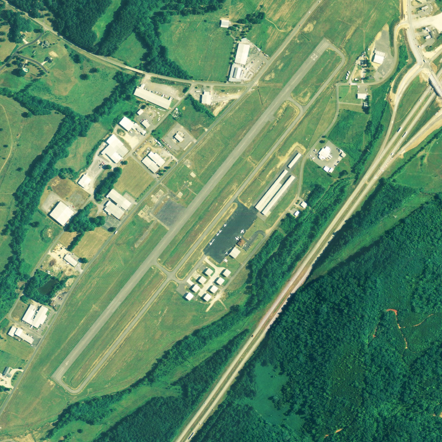
| Isbell Field |
 |
| NAIP aerial image, 15 June 2006 |
| IATA: none – ICAO: none – FAA LID: 4A9 |
| Summary |
| Airport type |
Public |
| Owner |
City of Fort Payne |
| Serves |
Fort Payne, Alabama |
| Elevation AMSL |
877 ft / 267 m |
| Coordinates |
34°28′25″N 085°43′17″W / 34.47361°N 85.72139°W / 34.47361; -85.72139 |
| Runways |
| Direction |
Length |
Surface |
| ft |
m |
| 4/22 |
5,001 |
1,524 |
Asphalt |
| Statistics (2009) |
| Aircraft operations |
16,470 |
| Based aircraft |
56 |
| Source: Federal Aviation Administration |
Isbell Field (FAA LID: 4A9) is a city-owned public-use airport located two nautical miles (3.7 km) north of the central business district of Fort Payne, a city in DeKalb County, Alabama, United States. According to the FAA's National Plan of Integrated Airport Systems for 2009–2013, it is categorized as a general aviation facility.
Facilities and aircraft
Isbell Field covers an area of 126 acres (51 ha) at an elevation of 877 feet (267 m) above mean sea level. It has one runway designated 4/22 with an asphalt surface measuring 5,001 by 100 feet (1,524 x 30 m).
For the 12-month period ending May 12, 2009, the airport had 16,470 general aviation aircraft operations, an average of 45 per day. At that time there were 56 aircraft based at this airport: 82% single-engine, 13% multi-engine and 5% jet.
The above content comes from Wikipedia and is published under free licenses – click here to read more.

Location
& QuickFacts
|
FAA Information Effective: |
2007-01-18 |
|
Airport
Identifier: |
4A9 |
|
Airport
Status: |
Operational |
|
Longitude/Latitude: |
085-43-17.0500W/34-28-25.3100N
-85.721403/34.473697 (Estimated) |
|
Elevation: |
877 ft / 267.31 m (Surveyed) |
|
Land: |
126 acres |
|
From
nearest city: |
2 nautical miles N of Fort Payne, AL |
|
Location: |
De Kalb County, AL |
|
Magnetic Variation: |
01W (1990) |
Owner
& Manager
|
Ownership: |
Publicly owned |
|
Owner: |
City Of Fort Payne
BUTCH LANE, AIRPORT BOARD. |
|
Address: |
200 Gault Ave
Fort Payne, AL 35967 |
|
Phone
number: |
256-845-1524 |
|
Manager: |
Peggy Cowart |
|
Address: |
2200 Terminal Road
Fort Payne, AL 35967 |
|
Phone number: |
256-845-9129 |
Airport
Operations and Facilities
|
Airport Use: |
Open to public |
|
Wind
indicator: |
Yes |
|
Segmented
Circle: |
No |
|
Control
Tower: |
No |
|
Lighting
Schedule: |
DUSK-DAWN |
|
Beacon
Color: |
Clear-Green (lighted land airport)
ROTG BCN OTS INDEFLY. |
|
Landing
fee charge: |
No |
|
Sectional
chart: |
Atlanta |
|
Region: |
ASO - Southern |
|
Boundary
ARTCC: |
ZTL - Atlanta |
|
Tie-in
FSS: |
ANB - Anniston |
|
FSS
on Airport: |
No |
|
FSS
Toll Free: |
1-800-WX-BRIEF |
|
NOTAMs
Facility: |
ANB (NOTAM-d service avaliable) |
|
Federal Agreements: |
NGY |
Airport
Communications
|
CTAF: |
122.800 |
|
Unicom: |
122.800 |
Airport
Services
|
Fuel available: |
100LLA |
|
Airframe Repair: |
MAJOR |
|
Power Plant Repair: |
MAJOR |
|
Bottled
Oxygen: |
NONE |
|
Bulk
Oxygen: |
NONE |
|
Runway Information
Runway 04/22
|
Dimension: |
5001 x 100 ft / 1524.3 x 30.5 m |
|
Surface: |
ASPH, Good Condition |
|
Weight
Limit: |
Single wheel: 16000 lbs. |
|
Edge
Lights: |
Medium |
|
|
Runway 04 |
Runway 22 |
|
Longitude: |
085-43-36.0600W |
085-42-58.0300W |
|
Latitude: |
34-28-06.2400N |
34-28-44.3800N |
|
Elevation: |
856.00
ft |
873.00
ft |
|
Alignment: |
39 |
127 |
|
Traffic
Pattern: |
Left |
Left |
|
Markings: |
Basic, Good Condition |
Basic, Good Condition |
|
Obstruction: |
49 ft pole, 1353.0 ft from runway, 6 ft right
of centerline, 23:1 slope to clear |
45 ft pole, 1403.0 ft from runway, 103 ft left
of centerline, 26:1 slope to clear |
|
Radio Navigation
Aids
|
ID |
Type |
Name |
Ch |
Freq |
Var |
Dist |
|
FTP |
NDB |
Fort Payne |
|
426.00 |
01W |
3.7 nm |
|
ARF |
NDB |
Saratoga |
|
296.00 |
02W |
28.2 nm |
|
OYD |
NDB |
Floyd |
|
388.00 |
02W |
29.6 nm |
|
APT |
NDB |
Jasper |
|
382.00 |
02W |
35.9 nm |
|
OUK |
NDB |
Calhoun |
|
323.00 |
02W |
39.6 nm |
|
UWI |
NDB |
Whitfield |
|
400.00 |
03W |
42.8 nm |
|
UOS |
NDB |
Sewanee |
|
275.00 |
02E |
44.7 nm |
|
BGF |
NDB |
Boiling Fork |
|
263.00 |
02W |
45.7 nm |
|
EVZ |
NDB |
Cartersville |
|
308.00 |
04W |
46.6 nm |
|
HUA |
NDB |
Redstone |
|
287.00 |
00W |
49.7 nm |
|
GAD |
VOR/DME |
Gadsden |
070X |
112.30 |
02E |
34.9 nm |
|
RMG |
VORTAC |
Rome |
101X |
115.40 |
01E |
35.3 nm |
|
GQO |
VORTAC |
Choo Choo |
105X |
115.80 |
01E |
40.6 nm |
|
RQZ |
VORTAC |
Rocket |
059X |
112.20 |
02E |
49.1 nm |
Remarks
Based
Aircraft
|
Aircraft
based on field: |
50 |
|
Single
Engine Airplanes: |
43 |
|
Multi
Engine Airplanes: |
6 |
|
Jet Engine
Airplanes: |
1 |
Operational Statistics
Time Period: 2005-06-03
- 2006-06-02
|
Aircraft
Operations: |
46/Day |
|
General
Aviation Local: |
43.7% |
|
General
Aviation Itinerant: |
56.3% |
Isbell Field Airport
Address:
De Kalb County, AL
Tel:
256-845-1524,
256-845-9129
Images
and information placed above are from
http://www.airport-data.com/airport/4A9/
We
thank them for the data!
| General
Info |
| Country |
United
States |
| State |
ALABAMA
|
| FAA ID |
4A9
|
| Latitude |
34-28-25.310N
|
| Longitude |
085-43-17.050W
|
| Elevation |
877 feet
|
| Near City |
FORT PAYNE
|
We don't guarantee the information is fresh and accurate. The data may
be wrong or outdated.
For more up-to-date information please refer to other sources.
|
|