|
|
Huntsville International - Carl T Jones Field Airport |
Coordinates: 34°38â²14â³N 086°46â²30â³W / 34.63722°N 86.775°W / 34.63722; -86.775
Huntsville International Airport
Carl T. Jones Field |
 |
 |
| FAA Official Diagram |
| IATA: HSV â ICAO: KHSV â FAA LID: HSV
Location of the Huntsville International Airport
|
| Summary |
| Airport type |
Public |
| Owner |
Huntsville / Madison County Airport Authority |
| Location |
Huntsville, Alabama |
| Elevation AMSL |
629 ft / 192 m |
| Website |
www.hsvairport.org/hia/ |
| Runways |
| Direction |
Length |
Surface |
| ft |
m |
| 18L/36R |
10,006 |
3,050 |
Asphalt |
| 18R/36L |
12,600 |
3,840 |
Asphalt |
| Statistics (2009) |
| Aircraft operations |
61,200 |
| Based aircraft |
87 |
| Source: Federal Aviation Administration |
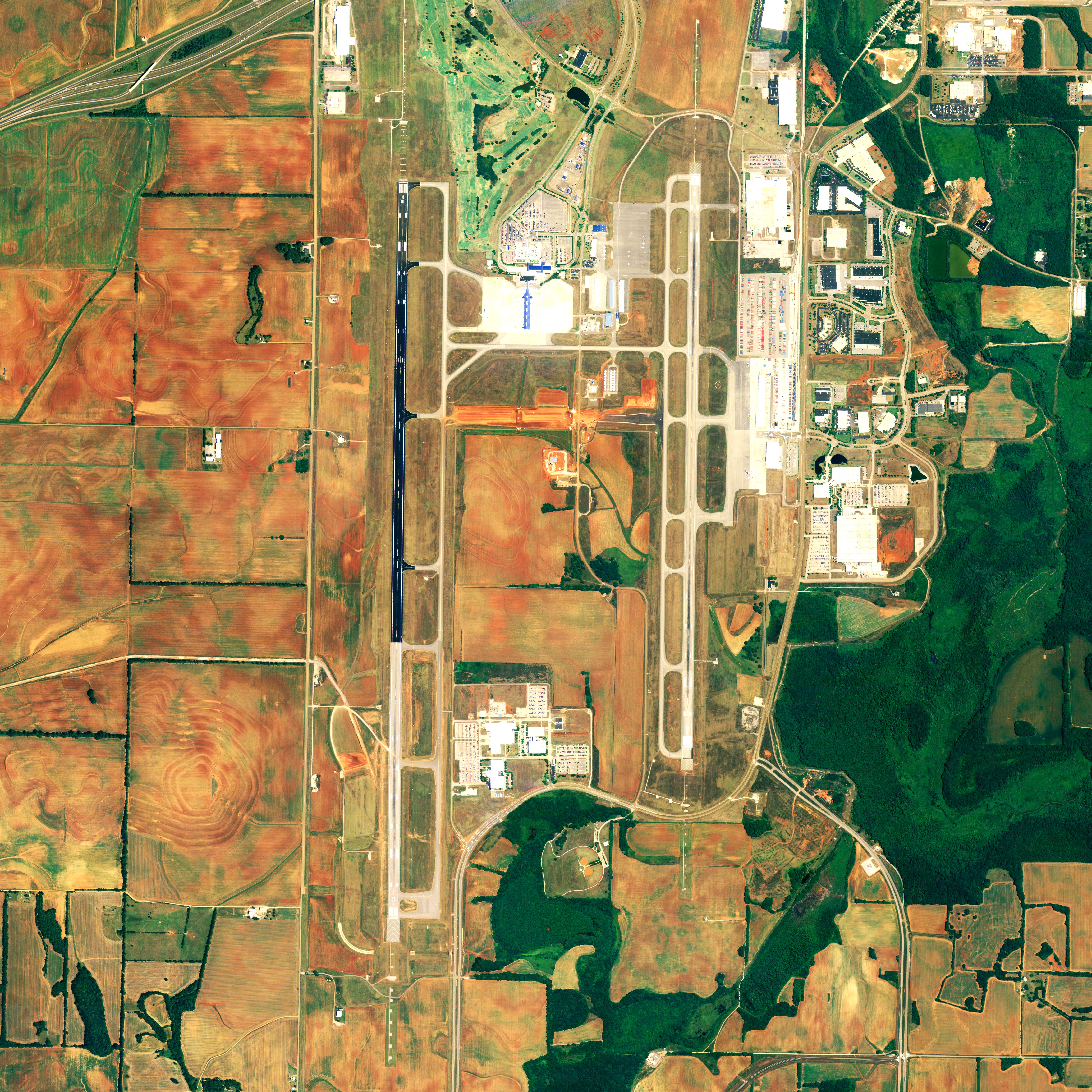
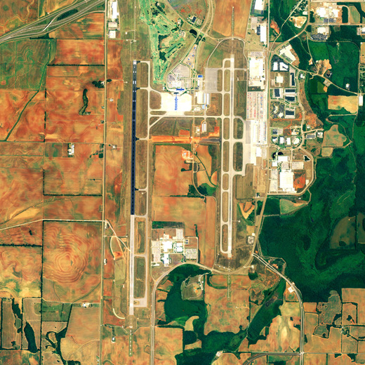
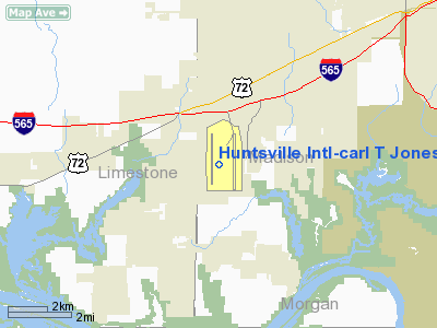
Huntsville International Airport (IATA: HSV, ICAO: KHSV, FAA LID: HSV), also known as Carl T. Jones Field, is an airport located 9 miles (14 km) southwest of the central business district of Huntsville, a city in Madison County, Alabama, United States. The airport is a part of the Port of Huntsville, and serves the Huntsville-Decatur Combined Statistical Area. It is located at 1000 Glenn Hearn Boulevard in Huntsville, Alabama. It has a single straight-forward layout with 12 gates and features restrooms, shops, restaurants, phones and large murals depicting various aviation and space exploration scenes. There is a Four Points by Sheraton above the ticketing area/lobby, and adjacent to the terminal is a parking garage and to opposite sides are the control tower and a golf course. The airport's west runway, at 12,600 ft (3,800 m), is the second longest in the Southeastern United States; it is smaller than the international runway at Miami International Airport.
The airport's "Fly Huntsville" custom jingle encourages passengers to depart directly from Huntsville instead of driving to Birmingham or Nashville. An August 2009 report by the Bureau of Transportation Statistics covering the first quarter of 2009 revealed that Huntsville passengers paid, on average, the highest airfares in the United States. The airport reported that commercial airline passenger traffic at Huntsville International increased 2.3 percent in January 2010 over the same period one year ago. Airlines and destinations
Huntsville International Airport is served by airlines representing all three international airline alliances.
| Airlines |
Destinations |
| AirTran Airways |
Baltimore, Orlando |
| American Airlines |
Dallas/Fort Worth |
| American Eagle |
Chicago-O'Hare |
| Continental Express operated by ExpressJet Airlines |
Houston-Intercontinental |
| Delta Air Lines |
Atlanta |
| Delta Connection operated by Atlantic Southeast Airlines |
Atlanta |
| Delta Connection operated by Comair |
Atlanta, Detroit, Washington-Reagan [ends November 10] |
| Delta Connection operated by Pinnacle Airlines |
Atlanta, Detroit, Memphis |
| United Express operated by Atlantic Southeast Airlines |
Chicago-O'Hare, Washington-Dulles |
| United Express operated by ExpressJet Airlines |
Chicago-O'Hare, Washington-Dulles |
| United Express operated by SkyWest Airlines |
Denver |
| US Airways Express operated by Air Wisconsin |
Washington-Reagan |
| US Airways Express operated by Mesa Airlines |
Charlotte |
| US Airways Express operated by PSA Airlines |
Charlotte, Washington-Reagan |
| US Airways Express operated by Republic Airlines |
Washington-Reagan |
| US Airways Express operated by Trans States Airlines |
Washington-Reagan |
Cargo
Huntsville International is the largest airport in Alabama in terms of cargo transport. Huntsville features daily cargo service to Europe, and frequent service to Mexico and Hong Kong. These airlines have Huntsville operations:
- ABX Air
- Atlas Air
- Cargolux
- FedEx Express
- Panalpina
- UPS Airlines
Expansion
In 1989, Huntsville International became the first airport in the United States to install an ASR-9 dual-channel airport surveillance radar system.
Currently, Huntsville International is undergoing major renovations of the concourse facilities, which will add:
- A $60 million terminal expansion (under construction)
- A new 219 ft (67 m) tall control tower (completed in 2007, opened May 4, 2008)
- An expanded 5,000 sq ft (460 m) concession area on concourse (opened April 12, 2008)
- Upgraded flight information display systems at gates & parking areas (completed in 2007)
- A parking deck expansion with 1,330 additional parking spaces (completed in December 2008)
- An enlarged 20,000 sq ft (1,900 m) public waiting and security screening area (completed in June 2009)
- An expansion on the west runway, making it the second longest in the southeast (completed in 2006)
- A new taxiway between both runways with a 269 ft (82 m) tunnel running underneath (under construction)
- A new air cargo building at the International Intermodal Center, which will include about 92,000 square feet (8,500 m) (completed in February 2009)
- Security system improvement (completed in October 2008)
- Taxiway "L" between the airport's east and west runways (completed in October 2008)
- Dirt work on a new Jetplex Industrial Park north access road linking the airport's entrance to Wall Triana Highway (completed in July 2008)
- AirTran started servicing HSV with direct flights to Orlando in May, 2010, and to Baltimore in June, 2010.
Also, plans are underway for another terminal area, added runways, and the lengthening of the two current runways.
The above content comes from Wikipedia and is published under free licenses – click here to read more.
Location
& QuickFacts
|
FAA Information Effective: |
2007-01-18 |
|
Airport
Identifier: |
HSV |
|
Airport
Status: |
Operational |
|
Longitude/Latitude: |
086-46-30.2000W/34-38-13.9000N
-86.775056/34.637194 (Estimated) |
|
Elevation: |
629 ft / 191.72 m (Surveyed) |
|
Land: |
4600 acres |
|
From
nearest city: |
9 nautical miles SW of Huntsville, AL |
|
Location: |
Madison County, AL |
|
Magnetic Variation: |
01W (1990) |
Owner
& Manager
|
Ownership: |
Publicly owned |
|
Owner: |
Huntsville Madison County
AIRPORT AUTHORITY |
|
Address: |
P O Box 20008
Huntsville, AL 35824 |
|
Phone number: |
256-772-9395
EXTN 260. |
|
Manager: |
Richard Tucker |
|
Address: |
Box 20008
Huntsville, AL 35824 |
|
Phone number: |
256-772-9395
EXTN 260. |
Airport
Operations and Facilities
|
Airport Use: |
Open to public |
|
Wind
indicator: |
Yes |
|
Segmented
Circle: |
Yes |
|
Control
Tower: |
Yes |
|
Lighting
Schedule: |
DUSK-DAWN
WHEN ATCT CLSD, ACTVT HIRL RYS 18R/36L & 18L/36R AND
TWY LGTS - CTAF. |
|
Beacon
Color: |
Clear-Green (lighted land airport) |
|
Landing
fee charge: |
No |
|
Sectional
chart: |
Atlanta |
|
Region: |
ASO - Southern |
|
Boundary
ARTCC: |
ZME - Memphis |
|
Tie-in
FSS: |
ANB - Anniston |
|
FSS
on Airport: |
No |
|
FSS
Toll Free: |
1-800-WX-BRIEF |
|
NOTAMs
Facility: |
HSV (NOTAM-d service avaliable) |
|
Certification type/date: |
I C S 01/2005 |
|
Federal Agreements: |
NGY |
Airport
Communications
|
CTAF: |
127.600 |
|
Unicom: |
122.950 |
Airport
Services
|
Fuel available: |
100LLA |
|
Airframe Repair: |
MAJOR |
|
Power Plant Repair: |
MAJOR |
|
Bottled
Oxygen: |
HIGH/LOW |
|
Bulk
Oxygen: |
HIGH/LOW |
|
Runway Information
Runway 18L/36R
|
Dimension: |
10006 x 150 ft / 3049.8 x 45.7 m |
|
Surface: |
ASPH, Good Condition |
|
Surface
Treatment: |
Saw-cut or plastic Grooved |
|
Weight
Limit: |
Single wheel: 90000 lbs.
Dual wheel: 200000 lbs.
Dual tandem wheel: 350000 lbs.
Dual dual tandem wheel: 850000 lbs. |
|
Edge
Lights: |
High |
|
|
Runway 18L |
Runway 36R |
|
Longitude: |
086-45-55.6732W |
086-45-57.6644W |
|
Latitude: |
34-39-11.1557N |
34-37-32.1961N |
|
Elevation: |
609.00
ft |
589.00
ft |
|
Alignment: |
127 |
1 |
|
ILS
Type: |
ILS |
ILS/DME |
|
Traffic
Pattern: |
Left |
Right |
|
Markings: |
Precision instrument, Good Condition |
Precision instrument, Good Condition |
|
Crossing
Height: |
70.00
ft |
55.00
ft |
|
Displaced
threshold: |
0.00 ft |
206.00
ft |
|
VASI: |
4-light PAPI on right side |
4-box on left side |
|
Visual
Glide Angle: |
3.00° |
3.00° |
|
Approach
lights: |
MALSR |
MALSR |
|
Runway
End Identifier: |
|
No |
|
Decleard
distances: |
Take off run available 10000.00 ft
Take off distance available 10000.00 ft
Actual stop distance available 9800.00 ft
Landing distance available 9800.00 ft |
Take off run available 10000.00 ft
Take off distance available 10000.00 ft
Actual stop distance available 10000.00 ft
Landing distance available 9800.00 ft |
|
Runway 18R/36L
|
Dimension: |
12600 x 150 ft / 3840.5 x 45.7 m |
|
Surface: |
ASPH, Good Condition |
|
Surface
Treatment: |
Saw-cut or plastic Grooved |
|
Weight
Limit: |
Single wheel: 90000 lbs.
Dual wheel: 200000 lbs.
Dual tandem wheel: 350000 lbs.
Dual dual tandem wheel: 850000 lbs. |
|
Edge
Lights: |
High |
|
|
Runway 18R |
Runway 36L |
|
Longitude: |
086-46-55.5620W |
086-46-58.0470W |
|
Latitude: |
34-39-10.0270N |
34-37-05.4170N |
|
Elevation: |
628.00
ft |
611.00
ft |
|
Alignment: |
127 |
1 |
|
ILS
Type: |
ILS |
ILS |
|
Traffic
Pattern: |
Right |
Left |
|
Markings: |
Precision instrument, Good Condition |
Precision instrument, Good Condition |
|
RVR
Equipment: |
touchdown |
|
|
Approach
lights: |
ALSF2 |
MALSR |
|
Centerline
Lights: |
Yes |
Yes |
|
Touchdown
Lights: |
Yes |
Yes |
|
Decleard
distances: |
Take off run available 12600.00 ft
Take off distance available 12600.00 ft
Actual stop distance available 12600.00 ft
Landing distance available 12600.00 ft |
Take off run available 12600.00 ft
Take off distance available 12600.00 ft
Actual stop distance available 12600.00 ft
Landing distance available 12600.00 ft |
|
Radio Navigation
Aids
|
ID |
Type |
Name |
Ch |
Freq |
Var |
Dist |
|
HUA |
NDB |
Redstone |
|
287.00 |
00W |
5.7 nm |
|
CWH |
NDB |
Capshaw |
|
350.00 |
01W |
8.2 nm |
|
CPP |
NDB |
Cole Spring |
|
230.00 |
01W |
16.4 nm |
|
TNY |
NDB |
Kelso |
|
358.00 |
01W |
32.0 nm |
|
GZS |
NDB |
Giles/dcmsnd |
|
375.00 |
00E |
33.9 nm |
|
ARF |
NDB |
Saratoga |
|
296.00 |
02W |
35.8 nm |
|
LRT |
NDB |
Lawrenceburg |
|
269.00 |
00E |
43.2 nm |
|
BGF |
NDB |
Boiling Fork |
|
263.00 |
02W |
47.7 nm |
|
DCU |
VOR/DME |
Decatur |
075X |
112.80 |
01W |
8.2 nm |
|
RQZ |
VORTAC |
Rocket |
059X |
112.20 |
02E |
11.9 nm |
|
MSL |
VORTAC |
Muscle Shoals |
112X |
116.50 |
01E |
35.7 nm |
|
HSV |
VOT |
Huntsville |
|
111.00 |
|
20.7 nm |
Remarks
- COMPASS
CALIBRATION PAD ON GA RAMP NON-STANDARD CONFIGURATION AND OUT OF CALIBRATION
INDEFLY.
- APRXLY
300 FT OF TWY J SOUTH OF THE TERMINAL; SE PORTION OF TWY G WHERE IT
ENTERS THE ACR APRON; & APRXLY 75 FT OF TWY E BTN TWYS E5 &
E6 ARE NOT VSB FROM THE ATCT.
- INTXN
OF TWY J AND SERVICE RD IS UNCONTROLLED.
- APRXLY
2200 FT OF TWY W SOUTH OF TWY W-5 NOT VISIBLE FROM TWR.
- PAEW
NORTH SIDE OF TWY J AT AIR CARRIER APRON.
Based
Aircraft
|
Aircraft
based on field: |
101 |
|
Single
Engine Airplanes: |
68 |
|
Multi
Engine Airplanes: |
20 |
|
Jet Engine
Airplanes: |
10 |
|
Helicopters: |
3 |
Major Carriers
Serving This Airport
| American Eagle Airlines Inc. |
29.0% |
| Atlantic Southeast Airlines |
20.3% |
| Expressjet Airlines Inc. |
19.9% |
| Delta Air Lines Inc. |
11.8% |
| American Airlines Inc. |
11.4% |
| Comair Inc. |
7.7% |
Most Popular Destinations
|
Dallas/fort
Worth Intl (DFW) |
28.9% |
|
Hartsfield
- Jackson Atlanta Intl (ATL) |
26.1% |
|
George
Bush Intercontinental/houston (IAH) |
19.9% |
|
Chicago O'hare Intl (ORD) |
11.4% |
|
Ronald
Reagan Washington National (DCA) |
9.8% |
|
Cincinnati/northern
Kentucky Intl (CVG) |
2.3% |
|
Orlando Intl (MCO) |
1.6% |
Most Popular Aircraft
|
N14516 |
1.3% |
|
N12528 |
1.1% |
|
N17513 |
1.0% |
|
N14514 |
1.0% |
|
N12519 |
0.9% |
|
N29515 |
0.9% |
|
N14522 |
0.8% |
|
N12530 |
0.8% |
|
N16520 |
0.7% |
|
N28518 |
0.7% |
Operational Statistics
Time Period: 2005-11-01
- 2006-10-31
|
Aircraft
Operations: |
266/Day |
|
Commerical: |
6.5% |
|
Air Taxi: |
27.2% |
|
General
Aviation Local: |
17.7% |
|
General
Aviation Itinerant: |
20.8% |
|
Military: |
27.9% |
Huntsville International-carl T Jones
Field Airport
Address:
Madison County, AL
Tel:
256-772-9395
Images
and information placed above are from
http://www.airport-data.com/airport/HSV/
We
thank them for the data!
| General
Info |
| Country |
United
States |
| State |
ALABAMA
|
| FAA ID |
HSV
|
| Latitude |
34-38-25.611N
|
| Longitude |
086-46-23.194W
|
| Elevation |
629 feet
|
| Near City |
HUNTSVILLE
|
We don't guarantee the information is fresh and accurate. The data may
be wrong or outdated.
For more up-to-date information please refer to other sources.
|
|