 |
|
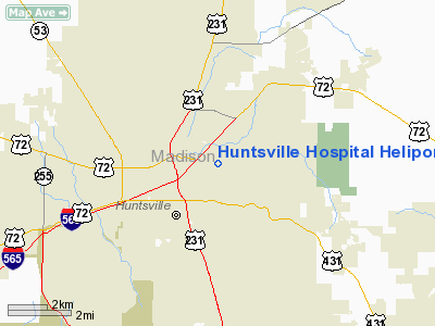
Huntsville Hospital Heliport |
Location
& QuickFacts
|
FAA Information Effective: |
2007-01-18 |
|
Airport
Identifier: |
AL28 |
|
Airport
Status: |
Operational |
|
Longitude/Latitude: |
086-34-26.9710W/34-44-14.3270N
-86.574159/34.737313 (Estimated) |
|
Elevation: |
644 ft / 196.29 m (Estimated) |
|
Land: |
0
acres |
|
From
nearest city: |
10 nautical miles N of Huntsville, AL |
|
Location: |
Madison County, AL |
|
Magnetic Variation: |
00W (1985) |
Owner
& Manager
|
Ownership: |
Privately owned |
|
Owner: |
Huntsville Hospital |
|
Address: |
911 Big Cove Road
Huntsville, AL 35801 |
|
Phone
number: |
256-517-7673 |
|
Manager: |
E-r Charge Nurse |
|
Address: |
Huntsville Hospital, 911 Big Cove Road
Huntsville, AL 35801 |
|
Phone number: |
256-517-7673 |
Airport
Operations and Facilities
|
Airport Use: |
Private |
|
Wind
indicator: |
Yes |
|
Segmented
Circle: |
No |
|
Control
Tower: |
No |
|
Lighting
Schedule: |
DUSK-DAWN |
|
Sectional
chart: |
Atlanta |
|
Region: |
ASO - Southern |
|
Boundary
ARTCC: |
ZME - Memphis |
|
Tie-in
FSS: |
ANB - Anniston |
|
FSS
Toll Free: |
1-800-WX-BRIEF |
|
Runway Information
Helipad H1
|
Dimension: |
20
x 20 ft / 6.1 x 6.1 m |
|
Surface: |
ASPH, |
|
|
Runway H1 |
Runway |
|
Traffic
Pattern: |
Left |
Left |
|
Radio Navigation
Aids
|
ID |
Type |
Name |
Ch |
Freq |
Var |
Dist |
|
SYI |
FAN MARKER |
Bomar |
|
|
01W |
45.2 nm |
|
HUA |
NDB |
Redstone |
|
287.00 |
00W |
6.1 nm |
|
CWH |
NDB |
Capshaw |
|
350.00 |
01W |
10.4 nm |
|
TNY |
NDB |
Kelso |
|
358.00 |
01W |
23.9 nm |
|
CPP |
NDB |
Cole Spring |
|
230.00 |
01W |
25.4 nm |
|
ARF |
NDB |
Saratoga |
|
296.00 |
02W |
33.9 nm |
|
GZS |
NDB |
Giles/dcmsnd |
|
375.00 |
00E |
34.5 nm |
|
BGF |
NDB |
Boiling Fork |
|
263.00 |
02W |
36.4 nm |
|
UOS |
NDB |
Sewanee |
|
275.00 |
02E |
43.6 nm |
|
LRT |
NDB |
Lawrenceburg |
|
269.00 |
00E |
45.2 nm |
|
FTP |
NDB |
Fort Payne |
|
426.00 |
01W |
46.4 nm |
|
ULH |
NDB |
Burwi |
|
332.00 |
03W |
46.5 nm |
|
LUG |
NDB |
Verona |
|
251.00 |
00W |
47.3 nm |
|
UXM |
VOR |
Tullahoma Regional |
|
109.65 |
03W |
41.9 nm |
|
DCU |
VOR/DME |
Decatur |
075X |
112.80 |
01W |
18.8 nm |
|
RQZ |
VORTAC |
Rocket |
059X |
112.20 |
02E |
4.7 nm |
|
MSL |
VORTAC |
Muscle Shoals |
112X |
116.50 |
01E |
45.4 nm |
|
HSV |
VOT |
Huntsville |
|
111.00 |
|
17.7 nm |
Remarks
- VFR
PVT USE; INGRESS FM N; EGRESS TO THE W; TREES REMOVED; NO VEHICLE PARKING.
Huntsville Hospital Heliport
Address:
Madison County, AL
Tel:
256-517-7673
Images
and information placed above are from
http://www.airport-data.com/airport/AL28/
We
thank them for the data!
| General
Info |
| Country |
United
States |
| State |
ALABAMA
|
| FAA ID |
AL28
|
| Latitude |
34-44-14.327N
|
| Longitude |
086-34-26.971W
|
| Elevation |
644 feet
|
| Near City |
HUNTSVILLE
|
We don't guarantee the information is fresh and accurate. The data may
be wrong or outdated.
For more up-to-date information please refer to other sources.
|
|


