 |
|
Headland Municipal Airport |
| Headland Municipal Airport |
 |
| IATA: none – ICAO: none – FAA LID: 0J6 |
| Summary |
| Airport type |
Public |
| Owner |
Headland, Alabama |
| Serves |
Headland, Alabama |
| Elevation AMSL |
359 ft / 109.4 m |
| Coordinates |
31°21′51″N 085°18′42″W / 31.36417°N 85.31167°W / 31.36417; -85.31167 |
| Website |
www.flyheadland.org |
| Runways |
| Direction |
Length |
Surface |
| ft |
m |
| 9/27 |
5,002 |
1,525 |
Asphalt |
| 17/35 |
2,885 |
879 |
Asphalt |
| Statistics (2000) |
| Aircraft operations |
41,203 |
| Source: Federal Aviation Administration |
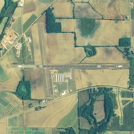
Headland Municipal Airport (FAA LID: 0J6) is a city-owned public-use airport located 2 nautical miles (4 km) northeast of the central business district of Headland, a city in Henry County, Alabama, United States.
Facilities and aircraft
Headland Municipal Airport covers an area of 328 acres (0.51 sq mi; 1.33 km) which contains two runways. Runway 9/27 is 5,002 x 80 feet (1525 x 24 meters) with asphalt pavement. Runway 17/35 is 2,885 x 162 feet (879 x 49 meters) with asphalt pavement. For the 12-month period ending June 5, 2000, the airport had 41,203 general aviation/military aircraft operations.
The above content comes from Wikipedia and is published under free licenses – click here to read more.

Location
& QuickFacts
|
FAA Information Effective: |
2007-01-18 |
|
Airport
Identifier: |
0J6 |
|
Airport
Status: |
Operational |
|
Longitude/Latitude: |
085-18-42.0600W/31-21-50.8910N
-85.311683/31.364136 (Estimated) |
|
Elevation: |
359 ft / 109.42 m (Surveyed) |
|
Land: |
328 acres |
|
From
nearest city: |
2 nautical miles NE of Headland, AL |
|
Location: |
Henry County, AL |
|
Magnetic Variation: |
03W (2005) |
Owner
& Manager
|
Ownership: |
Publicly owned |
|
Owner: |
City Of Headland |
|
Address: |
Po Box 67
Headland, AL 36345 |
|
Phone
number: |
334-693-3365 |
|
Manager: |
Stephanie Blankenship |
|
Address: |
P.o. Box 128
Headland, AL 36345 |
|
Phone number: |
334-693-9415 |
Airport
Operations and Facilities
|
Airport Use: |
Open to public |
|
Wind
indicator: |
Yes |
|
Segmented
Circle: |
Yes |
|
Control
Tower: |
No |
|
Lighting
Schedule: |
DUSK-DAWN
ACTVT MIRL RY 09/27 - CTAF. |
|
Beacon
Color: |
Clear-Green (lighted land airport) |
|
Landing
fee charge: |
No |
|
Sectional
chart: |
New Orleans |
|
Region: |
ASO - Southern |
|
Boundary
ARTCC: |
ZJX - Jacksonville |
|
Tie-in
FSS: |
ANB - Anniston |
|
FSS
on Airport: |
No |
|
FSS
Toll Free: |
1-800-WX-BRIEF |
|
NOTAMs
Facility: |
ANB (NOTAM-d service avaliable) |
|
Federal Agreements: |
NGRY |
Airport
Communications
Airport
Services
|
Fuel available: |
100LL |
|
Power Plant Repair: |
MINOR |
|
Bottled
Oxygen: |
NONE |
|
Bulk
Oxygen: |
NONE |
|
Runway Information
Runway 09/27
|
Dimension: |
5002 x 80 ft / 1524.6 x 24.4 m |
|
Surface: |
ASPH, Good Condition |
|
Weight
Limit: |
Single wheel: 12000 lbs. |
|
Edge
Lights: |
Medium |
|
|
Runway 09 |
Runway 27 |
|
Longitude: |
085-19-08.6800W |
085-18-10.9900W |
|
Latitude: |
31-21-49.8800N |
31-21-49.0900N |
|
Elevation: |
354.00
ft |
355.00
ft |
|
Alignment: |
91 |
127 |
|
Traffic
Pattern: |
Left |
Left |
|
Markings: |
Basic, Good Condition |
Basic, Good Condition |
|
Obstruction: |
26 ft pline, 1131.0 ft from runway, 130 ft
right of centerline, 35:1 slope to clear |
67 ft trees, 1560.0 ft from runway, 8 ft left
of centerline, 20:1 slope to clear |
|
Runway 17/35
|
Dimension: |
2885 x 162 ft / 879.3 x 49.4 m |
|
Surface: |
TURF, Good Condition |
|
|
Runway 17 |
Runway 35 |
|
Longitude: |
085-18-55.7200W |
085-18-52.5200W |
|
Latitude: |
31-22-07.5400N |
31-21-39.1200N |
|
Elevation: |
356.00
ft |
357.00
ft |
|
Alignment: |
127 |
127 |
|
Traffic
Pattern: |
Left |
Left |
|
Obstruction: |
18 ft tree, 405.0 ft from runway, 80 ft right
of centerline, 22:1 slope to clear |
27 ft bldg, 557.0 ft from runway, 82 ft left
of centerline, 20:1 slope to clear |
|
Radio Navigation
Aids
|
ID |
Type |
Name |
Ch |
Freq |
Var |
Dist |
|
HYE |
NDB |
Hanchey |
|
221.00 |
00E |
17.4 nm |
|
LOR |
NDB |
Lowe |
|
269.00 |
03W |
22.2 nm |
|
IWJ |
NDB |
Blaak |
|
344.00 |
03W |
25.9 nm |
|
OZ |
NDB |
Ruckr |
|
212.00 |
00E |
27.2 nm |
|
SMY |
NDB |
Soyya |
|
329.00 |
02W |
29.9 nm |
|
BKK |
NDB |
Tri County |
|
275.00 |
02W |
34.2 nm |
|
BVG |
NDB |
Boll Weevil |
|
352.00 |
03E |
34.5 nm |
|
XNE |
NDB |
Spring Hill |
|
281.00 |
00E |
39.0 nm |
|
LYZ |
NDB |
Willis |
|
359.00 |
01W |
46.8 nm |
|
TO |
NDB |
Blood |
|
365.00 |
01W |
49.4 nm |
|
HEY |
VOR |
Hanchey |
|
110.60 |
02E |
17.5 nm |
|
EDN |
VOR |
Enterprise |
|
116.60 |
03W |
30.6 nm |
|
FYL |
VOR |
Tri County |
|
108.40 |
08W |
34.9 nm |
|
OZR |
VOR/DME |
Cairns |
049X |
111.20 |
02E |
22.0 nm |
|
RRS |
VORTAC |
Wiregrass |
053X |
111.60 |
02E |
7.8 nm |
|
MAI |
VORTAC |
Marianna |
087X |
114.00 |
00E |
36.0 nm |
|
EUF |
VORTAC |
Eufaula |
029X |
109.20 |
02E |
36.4 nm |
Remarks
- RWY35
FARM EQUIP. AND AIRCRAFT MAYBE PARKED CLOSE TO RWY THR.
- RWY
17/35 +2 INCH LIP WHERE RWY INTERSECTS RWY 09/27.
- PRIOR
TO FAA ACTION.
Based
Aircraft
|
Aircraft
based on field: |
47 |
|
Single
Engine Airplanes: |
45 |
|
Multi
Engine Airplanes: |
1 |
|
Helicopters: |
1 |
Operational Statistics
Time Period: 1999-06-07
- 2000-06-05
|
Aircraft
Operations: |
113/Day |
|
General
Aviation Local: |
13.4% |
|
General
Aviation Itinerant: |
76.9% |
|
Military: |
9.7% |
Headland Municipal Airport
Address:
Henry County, AL
Tel:
334-693-3365,
334-693-9415
Images
and information placed above are from
http://www.airport-data.com/airport/0J6/
We
thank them for the data!
| General
Info |
| Country |
United
States |
| State |
ALABAMA
|
| FAA ID |
0J6
|
| Latitude |
31-21-53.622N
|
| Longitude |
085-18-34.760W
|
| Elevation |
359 feet
|
| Near City |
HEADLAND
|
We don't guarantee the information is fresh and accurate. The data may
be wrong or outdated.
For more up-to-date information please refer to other sources.
|
|


