|
|
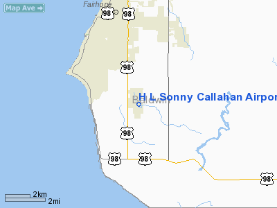
H L Sonny Callahan Airport |
| H. L. "Sonny" Callahan Airport |
 |
| IATA: none â ICAO: none â FAA LID: 4R4 |
| Summary |
| Airport type |
Public |
| Owner |
City of Fairhope |
| Location |
Fairhope, Alabama |
| Elevation AMSL |
95 ft / 29 m |
| Coordinates |
30°27â²38â³N 087°52â²37â³W / 30.46056°N 87.87694°W / 30.46056; -87.87694 |
| Runways |
| Direction |
Length |
Surface |
| ft |
m |
| 1/19 |
6,604 |
2,013 |
Asphalt |
| Statistics (2006) |
| Aircraft operations |
46,800 |
| Based aircraft |
38 |
| Source: Federal Aviation Administration |
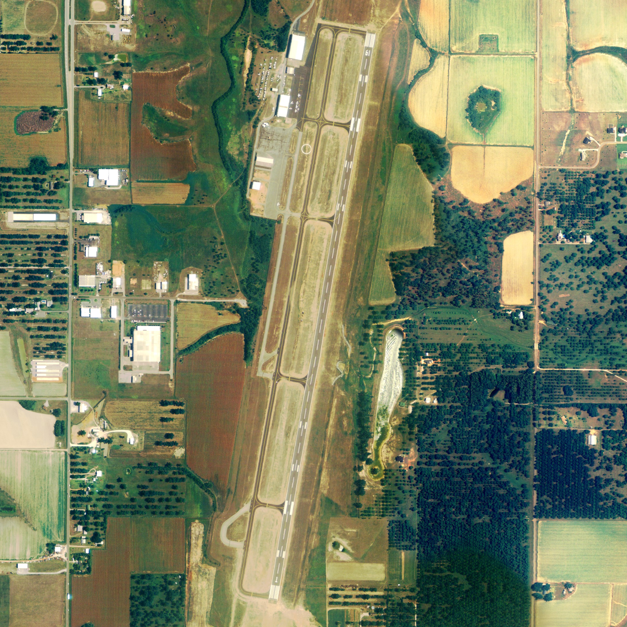
H. L. "Sonny" Callahan Airport (FAA LID: 4R4) is a public airport located three miles (5 km) southeast of the central business district of Fairhope, in Baldwin County, Alabama, United States.
Traffic at the airport is primarily corporate and private. Scheduled service for this region is provided by Mobile Regional Airport and Pensacola Regional Airport.
In March, 2007, the city of Fairhope turned over control of the airport to the airport authority and loaned the authority $8.8 million for improvements. The authority expects to use the money to build new hangers and a new terminal.
Facilities and aircraft
H. L. "Sonny" Callahan Airport covers an area of 144 acres (58 ha) which contains one paved runway (1/19) measuring 6,604 x 100 ft (2,013 x 30 m).
There is a small FBO on the field. The airport is attended daily, year round from 0600-2000. The field offers two RNAV (GPS) approaches and one VOR DME approach.
For 12-month period ending March 28, 2006, the airport had 46,800 aircraft operations, an average of 128 per day: 98% general aviation and 2% military. There are 38 aircraft based at this airport: 71% single engine, 21% multi-engine and 8% jet aircraft.
Passenger Service:
- DayJet (nonstop service to Jacksonville, Lakeland, Tallahassee, Pensacola, Gainesville, Boca Raton, Opa-Locka/Miami Dade County, Naples, Sarasota/Bradenton, Savannah, Macon, and Montgomery with more nonstop cities being added)
The above content comes from Wikipedia and is published under free licenses – click here to read more.
Location
& QuickFacts
|
FAA Information Effective: |
2007-01-18 |
|
Airport
Identifier: |
4R4 |
|
Airport
Status: |
Operational |
|
Longitude/Latitude: |
087-52-37.3150W/30-27-37.8350N
-87.877032/30.460510 (Estimated) |
|
Elevation: |
95
ft / 28.96 m (Surveyed) |
|
Land: |
144 acres |
|
From
nearest city: |
3 nautical miles SE of Fairhope, AL |
|
Location: |
Baldwin County, AL |
|
Magnetic Variation: |
01W (1980) |
Owner
& Manager
|
Ownership: |
Publicly owned |
|
Owner: |
City Of Fairhope |
|
Address: |
Po Drawer 429
Fairhope, AL 36533 |
|
Phone
number: |
251-928-2136 |
|
Manager: |
W. Colton Coile
CHAIRMAN, ARPT BOARD. |
|
Address: |
Po Box 1230
Fairhope, AL 36533 |
|
Phone number: |
251-929-0670 |
Airport
Operations and Facilities
|
Airport Use: |
Open to public |
|
Wind
indicator: |
Yes |
|
Segmented
Circle: |
No |
|
Control
Tower: |
No |
|
Lighting
Schedule: |
DUSK-DAWN
HIRL RY 01/19 PRESET ON LOW INTST; TO INCR INST AND ACTVT
REIL RY 01/19 - CTAF. |
|
Beacon
Color: |
Clear-Green (lighted land airport) |
|
Landing
fee charge: |
No |
|
Sectional
chart: |
New Orleans |
|
Region: |
ASO - Southern |
|
Boundary
ARTCC: |
ZJX - Jacksonville |
|
Responsible
ARTCC: |
ZHU - Houston |
|
Tie-in
FSS: |
ANB - Anniston |
|
FSS
on Airport: |
No |
|
FSS
Toll Free: |
1-800-WX-BRIEF |
|
NOTAMs
Facility: |
ANB (NOTAM-d service avaliable) |
|
Federal Agreements: |
NGY |
Airport
Communications
|
CTAF: |
123.000 |
|
Unicom: |
123.000 |
Airport
Services
|
Fuel available: |
100LLA |
|
Airframe Repair: |
MAJOR |
|
Power Plant Repair: |
MAJOR |
|
Runway Information
Runway 01/19
|
Dimension: |
6604 x 100 ft / 2012.9 x 30.5 m |
|
Surface: |
ASPH, Good Condition |
|
Surface
Treatment: |
Saw-cut or plastic Grooved |
|
Weight
Limit: |
Single wheel: 36000 lbs.
Dual wheel: 58000 lbs. |
|
Edge
Lights: |
High |
|
|
Runway 01 |
Runway 19 |
|
Longitude: |
087-52-43.4600W |
087-52-31.1700W |
|
Latitude: |
30-27-05.5900N |
30-28-10.0800N |
|
Elevation: |
86.00
ft |
91.00
ft |
|
Alignment: |
9 |
127 |
|
Traffic
Pattern: |
Left |
Left |
|
Markings: |
Precision instrument, Good Condition |
Precision instrument, Good Condition |
|
Crossing
Height: |
35.00
ft |
35.00
ft |
|
VASI: |
4-light PAPI on left side |
4-light PAPI on left side |
|
Visual
Glide Angle: |
3.00° |
3.00° |
|
Runway
End Identifier: |
Yes |
Yes |
|
Obstruction: |
, 50:1 slope to clear |
24 ft pole, 1082.0 ft from runway, 100 ft left
of centerline, 36:1 slope to clear |
|
Radio Navigation
Aids
|
ID |
Type |
Name |
Ch |
Freq |
Var |
Dist |
|
ESU |
NDB |
Summerdale |
|
204.00 |
01E |
8.2 nm |
|
MO |
NDB |
Wisle |
|
248.00 |
02E |
28.5 nm |
|
PKZ |
NDB |
Pickens |
|
326.00 |
01E |
36.2 nm |
|
NPA |
TACAN |
Pensacola |
119X |
|
01E |
29.7 nm |
|
NSE |
TACAN |
Whiting |
070X |
|
01E |
47.2 nm |
|
NGS |
TACAN |
Santa Rosa |
063X |
|
01E |
49.5 nm |
|
NUN |
VOR |
Saufley |
|
108.80 |
01E |
28.0 nm |
|
BFM |
VORTAC |
Brookley |
075X |
112.80 |
04E |
13.0 nm |
|
SJI |
VORTAC |
Semmes |
100X |
115.30 |
05E |
29.6 nm |
|
GCV |
VORTAC |
Greene County |
104X |
115.70 |
05E |
49.6 nm |
Based
Aircraft
|
Aircraft
based on field: |
38 |
|
Single
Engine Airplanes: |
27 |
|
Multi
Engine Airplanes: |
8 |
|
Jet Engine
Airplanes: |
3 |
Operational Statistics
Time Period: 2005-03-29
- 2006-03-28
|
Aircraft
Operations: |
129/Day |
|
General
Aviation Local: |
44.9% |
|
General
Aviation Itinerant: |
53.0% |
|
Military: |
2.1% |
H L Sonny Callahan Airport
Address:
Baldwin County, AL
Tel:
251-928-2136,
251-929-0670
Images
and information placed above are from
http://www.airport-data.com/airport/4R4/
We
thank them for the data!
| General
Info |
| Country |
United
States |
| State |
ALABAMA
|
| FAA ID |
4R4
|
| Latitude |
30-27-43.605N
|
| Longitude |
087-52-40.871W
|
| Elevation |
95 feet
|
| Near City |
FAIRHOPE
|
We don't guarantee the information is fresh and accurate. The data may
be wrong or outdated.
For more up-to-date information please refer to other sources.
|
|