 |
|
Grove Hill Municipal Airport |
| Grove Hill Municipal Airport |
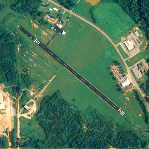 |
| NAIP aerial image, 2006 |
| IATA: none – ICAO: none – FAA LID: 3A0 |
| Summary |
| Airport type |
Public |
| Owner |
City of Grove Hill |
| Serves |
Grove Hill, Alabama |
| Elevation AMSL |
478 ft / 146 m |
| Coordinates |
31°41′22″N 087°45′41″W / 31.68944°N 87.76139°W / 31.68944; -87.76139 |
| Runways |
| Direction |
Length |
Surface |
| ft |
m |
| 13/31 |
2,704 |
824 |
Asphalt |
| Statistics (2010) |
| Aircraft operations |
2,490 |
| Based aircraft |
6 |
| Source: Federal Aviation Administration |
Grove Hill Municipal Airport (FAA LID: 3A0) is a city-owned public-use airport located two nautical miles (3.7 km) southeast of the central business district of Grove Hill, a city in Clarke County, Alabama, United States. According to the FAA's National Plan of Integrated Airport Systems for 2009–2013, it is categorized as a general aviation facility.
Facilities and aircraft
Grove Hill Municipal Airport covers an area of 130 acres (53 ha) at an elevation of 478 feet (146 m) above mean sea level. It has one runway designated 13/31 with an asphalt surface measuring 2,704 by 75 feet (824 x 23 m).
For the 12-month period ending February 23, 2010, the airport had 2,490 general aviation aircraft operations, an average of 207 per month. At that time there were 6 aircraft based at this airport: 83% single-engine and 17% multi-engine.
The above content comes from Wikipedia and is published under free licenses – click here to read more.

Location
& QuickFacts
|
FAA Information Effective: |
2007-01-18 |
|
Airport
Identifier: |
3A0 |
|
Airport
Status: |
Operational |
|
Longitude/Latitude: |
087-45-40.9950W/31-41-21.5660N
-87.761387/31.689324 (Estimated) |
|
Elevation: |
478 ft / 145.69 m (Estimated) |
|
Land: |
130 acres |
|
From
nearest city: |
2 nautical miles SE of Grove Hill, AL |
|
Location: |
Clarke County, AL |
|
Magnetic Variation: |
01E (1985) |
Owner
& Manager
|
Ownership: |
Publicly owned |
|
Owner: |
City Of Grove Hill |
|
Address: |
P.o.box 847
Grove Hill, AL 36451 |
|
Phone
number: |
251-275-3153 |
|
Manager: |
Edd Stifflemire |
|
Address: |
P.o.box 847
Grove Hill, AL 36451 |
|
Phone number: |
251-275-3153 |
Airport
Operations and Facilities
|
Airport Use: |
Open to public |
|
Wind
indicator: |
Yes |
|
Segmented
Circle: |
No |
|
Control
Tower: |
No |
|
Landing
fee charge: |
No |
|
Sectional
chart: |
New Orleans |
|
Region: |
ASO - Southern |
|
Boundary
ARTCC: |
ZTL - Atlanta |
|
Tie-in
FSS: |
ANB - Anniston |
|
FSS
on Airport: |
No |
|
FSS
Toll Free: |
1-800-WX-BRIEF |
|
NOTAMs
Facility: |
ANB (NOTAM-d service avaliable) |
|
Federal Agreements: |
N1 |
Airport
Communications
Airport
Services
|
Airframe Repair: |
NONE |
|
Power Plant Repair: |
NONE |
|
Bottled
Oxygen: |
NONE |
|
Bulk
Oxygen: |
NONE |
|
Runway Information
Runway 13/31
|
Dimension: |
2704
x 75 ft / 824.2 x 22.9 m
RY 13/31 W 500 FT CLSD INDEFLY. |
|
Surface: |
ASPH, Good Condition |
|
Weight
Limit: |
Single wheel: 12000 lbs. |
|
|
Runway 13 |
Runway 31 |
|
Traffic
Pattern: |
Left |
Left |
|
Markings: |
Basic, Good Condition |
Basic, Good Condition |
|
Displaced
threshold: |
0.00 ft |
65.00
ft |
|
Runway
End Identifier: |
No |
No |
|
Centerline
Lights: |
No |
No |
|
Touchdown
Lights: |
No |
No |
|
Obstruction: |
98 ft trees, 2787.0 ft from runway, 26:1 slope
to clear |
57 ft trees, 959.0 ft from runway, 207 ft right
of centerline, 13:1 slope to clear
OBSTN CLNC SLOPE 17:1 FM DSPLCD THLD. |
|
Radio Navigation
Aids
|
ID |
Type |
Name |
Ch |
Freq |
Var |
Dist |
|
BCZ |
NDB |
Choctaw |
|
228.00 |
01E |
31.5 nm |
|
RZO |
NDB |
Marengo |
|
391.00 |
01E |
45.5 nm |
|
MVC |
VORTAC |
Monroeville |
115X |
116.80 |
04E |
25.0 nm |
Remarks
Based
Aircraft
|
Aircraft
based on field: |
5 |
|
Single
Engine Airplanes: |
4 |
|
Multi
Engine Airplanes: |
1 |
Operational Statistics
Time Period: 2005-07-20
- 2006-07-19
|
Aircraft
Operations: |
48/Week |
|
General
Aviation Local: |
3.6% |
|
General
Aviation Itinerant: |
96.4% |
Grove Hill Municipal Airport
Address:
Clarke County, AL
Tel:
251-275-3153
Images
and information placed above are from
http://www.airport-data.com/airport/3A0/
We
thank them for the data!
| General
Info |
| Country |
United
States |
| State |
ALABAMA
|
| FAA ID |
3A0
|
| Latitude |
31-41-21.566N
|
| Longitude |
087-45-40.995W
|
| Elevation |
478 feet
|
| Near City |
GROVE
HILL |
We don't guarantee the information is fresh and accurate. The data may
be wrong or outdated.
For more up-to-date information please refer to other sources.
|
|


