 |
|
| Gragg-Wade Field |
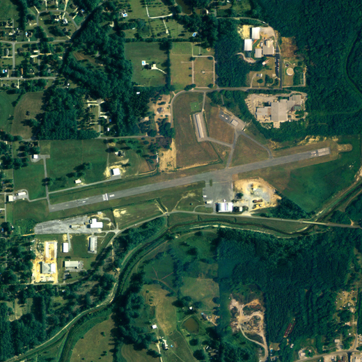 |
| NAIP aerial image, 22 June 2006 |
| IATA: none â ICAO: none â FAA LID: 02A |
| Summary |
| Airport type |
Public |
| Owner |
Chilton County Airport Authority |
| Serves |
Chilton County, Alabama |
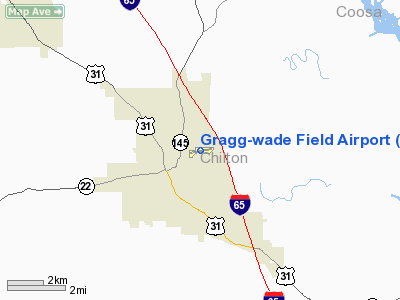
| Location |
Clanton, Alabama |
| Elevation AMSL |
585 ft / 178.3 m |
| Coordinates |
32°51â²02â³N 086°36â²41â³W / 32.85056°N 86.61139°W / 32.85056; -86.61139 |
| Runways |
| Direction |
Length |
Surface |
| ft |
m |
| 8/26 |
4,008 |
1,222 |
Asphalt |
| Statistics (2006) |
| Aircraft operations |
23,924 |
| Source: Federal Aviation Administration |
Gragg-Wade Field (FAA LID: 02A) is a county-owned public-use airport in Chilton County, Alabama, United States. It is located 1 nautical mile (2 km) east of the central business district of Clanton, Alabama According to the FAA's National Plan of Integrated Airport Systems for 2009â2013, it is categorized as a general aviation facility.
Facilities and aircraft
Gragg-Wade Field covers an area of 101 acres (0.16 sq mi; 0.41 km) which contains one runway designated 8/26 is 4,008 x 100 feet (1222 x 30 meters) asphalt pavement. For the 12-month period ending December 12, 2006, the airport had 23,924 general aviation aircraft operations.
The above content comes from Wikipedia and is published under free licenses – click here to read more.
Location
& QuickFacts
|
FAA Information Effective: |
2007-01-18 |
|
Airport
Identifier: |
02A |
|
Airport
Status: |
Operational |
|
Longitude/Latitude: |
086-36-41.1700W/32-51-01.7400N
-86.611436/32.850483 (Estimated) |
|
Elevation: |
585 ft / 178.31 m (Surveyed) |
|
Land: |
101 acres |
|
From
nearest city: |
1 nautical miles E of Clanton, AL |
|
Location: |
Chilton County, AL |
|
Magnetic Variation: |
00W (1985) |
Owner
& Manager
|
Ownership: |
Publicly owned |
|
Owner: |
Chilton County Airport Authority |
|
Address: |
Po Box 1984
Clanton, AL 35046 |
|
Phone number: |
205-755-6300 |
|
Manager: |
Airport Authority |
|
Address: |
700 Airport Road
Clanton, AL 35045 |
|
Phone number: |
205-280-3800 |
Airport
Operations and Facilities
|
Airport Use: |
Open to public |
|
Wind
indicator: |
Yes |
|
Segmented
Circle: |
No |
|
Control
Tower: |
No |
|
Lighting
Schedule: |
DUSK-DAWN |
|
Beacon
Color: |
Clear-Green (lighted land airport) |
|
Landing
fee charge: |
No |
|
Sectional
chart: |
Atlanta |
|
Region: |
ASO - Southern |
|
Boundary
ARTCC: |
ZTL - Atlanta |
|
Tie-in
FSS: |
ANB - Anniston |
|
FSS
on Airport: |
No |
|
FSS
Toll Free: |
1-800-WX-BRIEF |
|
NOTAMs
Facility: |
ANB (NOTAM-d service avaliable) |
|
Federal Agreements: |
N |
Airport
Communications
|
CTAF: |
122.800 |
|
Unicom: |
122.800 |
Airport
Services
|
Fuel available: |
100LL |
|
Airframe Repair: |
MAJOR |
|
Power Plant Repair: |
MAJOR |
|
Bottled
Oxygen: |
NONE |
|
Bulk
Oxygen: |
NONE |
|
Runway Information
Runway 08/26
|
Dimension: |
4008 x 100 ft / 1221.6 x 30.5 m |
|
Surface: |
ASPH, Good Condition |
|
Weight
Limit: |
Single wheel: 16000 lbs. |
|
Edge
Lights: |
Medium |
|
|
Runway 08 |
Runway 26 |
|
Longitude: |
086-37-04.1800W |
086-36-18.1600W |
|
Latitude: |
32-50-57.7400N |
32-51-05.7400N |
|
Elevation: |
585.00
ft |
566.00
ft |
|
Alignment: |
78 |
127 |
|
Traffic
Pattern: |
Left |
Left |
|
Markings: |
Non-precision instrument, Good Condition |
Non-precision instrument, Good Condition |
|
Crossing
Height: |
27.00
ft |
27.00
ft |
|
Displaced
threshold: |
819.00
ft |
0.00 ft |
|
VASI: |
nonstandard system
RY 08 SINGLE BOX VASI LEFT SIDE. |
nonstandard system
RY 26 SINGLE BOX VASI LEFT SIDE. RY
26 VASI OTS INDEFLY. |
|
Visual
Glide Angle: |
6.00° |
6.00° |
|
Obstruction: |
77 ft tree, 707.0 ft from runway, 121 ft left
of centerline, 6:1 slope to clear
RY 08 APCH RATIO 14:1 TO DSPLCD THLD. |
76 ft tree, 1007.0 ft from runway, 79 ft right
of centerline, 10:1 slope to clear |
|
Radio Navigation
Aids
|
ID |
Type |
Name |
Ch |
Freq |
Var |
Dist |
|
GGY |
NDB |
Gragg-wade |
|
338.00 |
01E |
0.2 nm |
|
SCD |
NDB |
Sylacauga |
|
284.00 |
03W |
24.4 nm |
|
BEQ |
NDB |
Bessemer |
|
368.00 |
00E |
31.9 nm |
|
DER |
NDB |
Alexander City |
|
382.00 |
01W |
32.9 nm |
|
SE |
NDB |
Pollk |
|
344.00 |
01W |
38.4 nm |
|
BH |
NDB |
Mcden |
|
224.00 |
01W |
41.4 nm |
|
PLR |
NDB |
Pell City |
|
257.00 |
01E |
46.3 nm |
|
MXF |
TACAN |
Maxwell |
097X |
|
03E |
30.9 nm |
|
JYU |
VOR/DME |
Junior |
083X |
113.60 |
01W |
36.0 nm |
|
OKW |
VORTAC |
Brookwood |
047X |
111.00 |
00E |
39.8 nm |
|
MGM |
VORTAC |
Montgomery |
058X |
112.10 |
03E |
40.6 nm |
|
BHM |
VOT |
Birmingham Muni |
|
110.00 |
|
43.4 nm |
Remarks
Based
Aircraft
|
Aircraft
based on field: |
21 |
|
Single
Engine Airplanes: |
16 |
|
Multi
Engine Airplanes: |
1 |
|
Helicopters: |
2 |
|
Ultralights: |
2 |
Operational Statistics
Time Period: 1999-05-27
- 2000-05-25
|
Aircraft
Operations: |
66/Day |
|
General
Aviation Local: |
5.1% |
|
General
Aviation Itinerant: |
94.9% |
Gragg-wade Field Airport
Address:
Chilton County, AL
Tel:
205-755-6300, 205-280-3800
Images
and information placed above are from
http://www.airport-data.com/airport/02A/
We
thank them for the data!
| General
Info |
| Country |
United
States |
| State |
ALABAMA
|
| FAA ID |
02A
|
| Latitude |
32-51-01.752N
|
| Longitude |
086-36-41.232W
|
| Elevation |
586 feet
|
| Near City |
CLANTON
|
We don't guarantee the information is fresh and accurate. The data may
be wrong or outdated.
For more up-to-date information please refer to other sources.
|
|


