 |
|
| George Downer Airport |
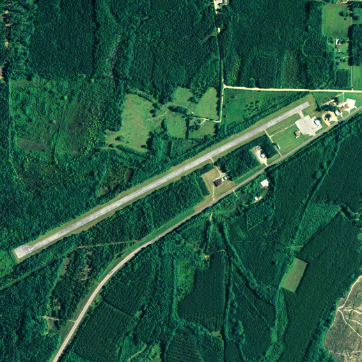 |
| NAIP aerial image, 21 June 2006 |
| IATA: AIV – ICAO: KAIV – FAA LID: AIV |
| Summary |
| Airport type |
Public |
| Owner |
City of Aliceville |
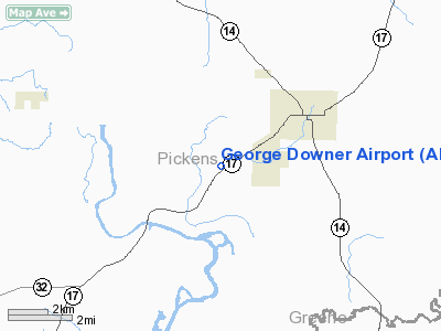
| Serves |
Aliceville, Alabama |
| Elevation AMSL |
150 ft / 45.7 m |
| Coordinates |
33°06′23″N 088°11′52″W / 33.10639°N 88.19778°W / 33.10639; -88.19778 |
| Runways |
| Direction |
Length |
Surface |
| ft |
m |
| 6/24 |
4,970 |
1,515 |
Asphalt |
| Statistics (2006) |
| Aircraft operations |
5,400 |
| Source: Federal Aviation Administration |
George Downer Airport (IATA: AIV, ICAO: KAIV, FAA LID: AIV) is a city-owned public-use airport located 2 nautical miles (4 km) southwest of the central business district of Aliceville, a city in Pickens County, Alabama, United States. According to the FAA's National Plan of Integrated Airport Systems for 2009–2013, it is categorized as a general aviation facility.
Facilities and aircraft
George Downer Airport covers an area of 41 acres (0.06 sq mi; 0.17 km) which contains one runway designated 6/24 is 4,970 x 80 feet (1,515 x 24 meters) asphalt. For the 12-month period ending July 26, 2006, the airport had 5,400 general aviation aircraft operations.
The above content comes from Wikipedia and is published under free licenses – click here to read more.
Location
& QuickFacts
|
FAA Information Effective: |
2007-01-18 |
|
Airport
Identifier: |
AIV |
|
Airport
Status: |
Operational |
|
Longitude/Latitude: |
088-11-52.0500W/33-06-23.2750N
-88.197792/33.106465 (Estimated) |
|
Elevation: |
150 ft / 45.72 m (Surveyed) |
|
Land: |
41
acres |
|
From
nearest city: |
2 nautical miles SW of Aliceville, AL |
|
Location: |
Pickens County, AL |
|
Magnetic Variation: |
01E (1985) |
Owner
& Manager
|
Ownership: |
Publicly owned |
|
Owner: |
City Of Aliceville |
|
Address: |
215 First St Ne
Aliceville, AL 35442 |
|
Phone
number: |
205-373-6611 |
|
Manager: |
City Of Aliceville |
|
Address: |
215 First St Ne
Aliceville, AL 35442 |
|
Phone number: |
205-373-6611 |
Airport
Operations and Facilities
|
Airport Use: |
Open to public |
|
Wind
indicator: |
Yes |
|
Segmented
Circle: |
No |
|
Control
Tower: |
No |
|
Lighting
Schedule: |
DUSK-DAWN |
|
Beacon
Color: |
Clear-Green (lighted land airport) |
|
Landing
fee charge: |
No |
|
Sectional
chart: |
Memphis |
|
Region: |
ASO - Southern |
|
Boundary
ARTCC: |
ZME - Memphis |
|
Tie-in
FSS: |
ANB - Anniston |
|
FSS
on Airport: |
No |
|
FSS
Toll Free: |
1-800-WX-BRIEF |
|
NOTAMs
Facility: |
ANB (NOTAM-d service avaliable) |
|
Federal Agreements: |
N |
Airport
Communications
|
CTAF: |
122.800 |
|
Unicom: |
122.800 |
Airport
Services
|
Airframe Repair: |
NONE |
|
Power Plant Repair: |
NONE |
|
Bottled
Oxygen: |
NONE |
|
Bulk
Oxygen: |
NONE |
|
Runway Information
Runway 06/24
|
Dimension: |
4970 x 80 ft / 1514.9 x 24.4 m |
|
Surface: |
ASPH, Poor Condition
CRACKED WITH VEGETATION, LOOSE AGGREGATE. |
|
Edge
Lights: |
Low |
|
|
Runway 06 |
Runway 24 |
|
Longitude: |
088-12-17.7600W |
088-11-26.3400W |
|
Latitude: |
33-06-11.6000N |
33-06-34.9500N |
|
Elevation: |
142.00
ft |
150.00
ft |
|
Traffic
Pattern: |
Left |
Left |
|
Markings: |
Basic, Poor Condition
RY MARKINGS FADED. |
Basic, Poor Condition
RY MARKINGS FADED. |
|
Displaced
threshold: |
193.00
ft |
613.00
ft |
|
Obstruction: |
16 ft trees, 223.0 ft from runway, 61 ft left
of centerline, 1:1 slope to clear
OBSTN CLNC SLOPE 26:1 FM DSPL THLD.
+13
FT TREES 41 FT FM THLD PERPENDICULAR TO RY END. |
43 ft trees, 307.0 ft from runway, 91 ft right
of centerline, 2:1 slope to clear
OBSTN CLNC SLOPE 21:1 FM DISP THLD.
+4' FENCE 122' FM & PARALLEL TO THR; +15' ROAD 174' FM
THR 125'R, +15' TREES 120' FM THR 115' R&L 40'-120'L. |
|
Radio Navigation
Aids
|
ID |
Type |
Name |
Ch |
Freq |
Var |
Dist |
|
AIV |
NDB |
Aliceville |
|
254.00 |
|
0.8 nm |
|
STF |
NDB |
Bryan |
|
281.00 |
02E |
38.2 nm |
|
EOG |
NDB |
Greensboro |
|
417.00 |
01E |
40.6 nm |
|
FDF |
NDB |
Fayette |
|
204.00 |
00E |
41.3 nm |
|
RZO |
NDB |
Marengo |
|
391.00 |
01E |
42.6 nm |
|
LMS |
NDB |
Louisville |
|
212.00 |
00E |
43.5 nm |
|
NMM |
TACAN |
Meridian |
056X |
|
01E |
36.3 nm |
|
NJW |
TACAN |
Joe Williams |
61Y |
|
01E |
37.2 nm |
|
IGB |
VORTAC |
Bigbee |
109X |
116.20 |
04E |
27.8 nm |
|
CBM |
VORTAC |
Caledonia |
099X |
115.20 |
00E |
34.4 nm |
|
LDK |
VORTAC |
Crimson |
125X |
117.80 |
03E |
34.5 nm |
|
EWA |
VORTAC |
Kewanee |
085X |
113.80 |
04E |
46.4 nm |
|
OKW |
VORTAC |
Brookwood |
047X |
111.00 |
00E |
48.4 nm |
Remarks
Operational
Statistics
Time Period: 2005-07-27
- 2006-07-26
|
Aircraft
Operations: |
104/Week |
|
General
Aviation Itinerant: |
100.0% |
George Downer Airport
Address:
Pickens County, AL
Tel:
205-373-6611
Images
and information placed above are from
http://www.airport-data.com/airport/AIV/
We
thank them for the data!
| General
Info |
| Country |
United
States |
| State |
ALABAMA
|
| FAA ID |
AIV
|
| Latitude |
33-06-25.448N
|
| Longitude |
088-11-50.106W
|
| Elevation |
150 feet
|
| Near City |
ALICEVILLE
|
We don't guarantee the information is fresh and accurate. The data may
be wrong or outdated.
For more up-to-date information please refer to other sources.
|
|


