 |
|
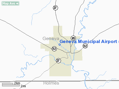
| Geneva Municipal Airport |
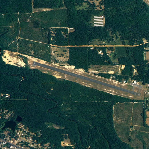 |
| NAIP aerial image, 2006 |
| IATA: none – ICAO: none – FAA LID: 33J |
| Summary |
| Airport type |
Public |
| Owner |
City of Geneva |
| Serves |
Geneva, Alabama |
| Elevation AMSL |
101 ft / 31 m |
| Coordinates |
31°03′09″N 085°52′08″W / 31.0525°N 85.86889°W / 31.0525; -85.86889 |
| Runways |
| Direction |
Length |
Surface |
| ft |
m |
| 11/29 |
3,984 |
1,214 |
Asphalt |
| Statistics (2009) |
| Aircraft operations |
9,069 |
| Based aircraft |
22 |
| Source: Federal Aviation Administration |
Geneva Municipal Airport (FAA LID: 33J) is a city-owned public-use airport located two nautical miles (3.7 km) north of the central business district of Geneva, a city in Geneva County, Alabama, United States. According to the FAA's National Plan of Integrated Airport Systems for 2009–2013, it is categorized as a general aviation facility.
Facilities and aircraft
Geneva Municipal Airport covers an area of 105 acres (42 ha) at an elevation of 101 feet (31 m) above mean sea level. It has one runway designated 11/29 with an asphalt surface measuring 3,984 by 98 feet (1,214 x 30 m).
For the 12-month period ending June 10, 2009, the airport had 9,069 aircraft operations, an average of 24 per day: 93% general aviation and 67% military. At that time there were 22 aircraft based at this airport, all single-engine.
The above content comes from Wikipedia and is published under free licenses – click here to read more.
Location
& QuickFacts
|
FAA Information Effective: |
2007-01-18 |
|
Airport
Identifier: |
33J |
|
Airport
Status: |
Operational |
|
Longitude/Latitude: |
085-52-49.2000W/31-03-19.0000N
-85.880333/31.055278 (Estimated) |
|
Elevation: |
101 ft / 30.78 m (Estimated) |
|
Land: |
105 acres |
|
From
nearest city: |
2 nautical miles N of Geneva, AL |
|
Location: |
Geneva County, AL |
|
Magnetic Variation: |
00W (1985) |
Owner
& Manager
|
Ownership: |
Publicly owned |
|
Owner: |
Town Of Geneva |
|
Address: |
Po Box 37
Geneva, AL 36340 |
|
Phone number: |
334-684-2485 |
|
Manager: |
Woodrow Williams |
|
Address: |
Route 1
Geneva, AL 36340 |
|
Phone number: |
334-684-3591 |
Airport
Operations and Facilities
|
Airport Use: |
Open to public |
|
Wind
indicator: |
Yes |
|
Segmented
Circle: |
No |
|
Control
Tower: |
No |
|
Lighting
Schedule: |
DUSK-DAWN |
|
Beacon
Color: |
Clear-Green (lighted land airport) |
|
Landing
fee charge: |
No |
|
Sectional
chart: |
New Orleans |
|
Region: |
ASO - Southern |
|
Traffic
Pattern Alt: |
900 ft |
|
Boundary
ARTCC: |
ZJX - Jacksonville |
|
Tie-in
FSS: |
ANB - Anniston |
|
FSS
on Airport: |
No |
|
FSS
Toll Free: |
1-800-WX-BRIEF |
|
NOTAMs
Facility: |
ANB (NOTAM-d service avaliable) |
|
Federal Agreements: |
N |
Airport
Communications
|
CTAF: |
122.800 |
|
Unicom: |
122.800 |
Airport
Services
|
Fuel available: |
100LL |
|
Airframe Repair: |
MINOR |
|
Power Plant Repair: |
MINOR |
|
Bottled
Oxygen: |
NONE |
|
Bulk
Oxygen: |
NONE |
|
Runway Information
Runway 11/29
|
Dimension: |
3984 x 98 ft / 1214.3 x 29.9 m |
|
Surface: |
ASPH, Poor Condition
RY 11/29 SFC CRACKED WITH GRASS GROWING THRU, TOP 1/2 INCH OF RY
CONSISTS OF LOOSE AGGREGATE 615 FT FROM RY 11. |
|
Weight
Limit: |
Single wheel: 16000 lbs. |
|
Edge
Lights: |
Medium
LGTD THLD RELOCATED 145 FT ON EAST END; 3839 FT LGTD AT NIGHT. |
|
|
Runway 11 |
Runway 29 |
|
Traffic
Pattern: |
Left |
Left |
|
Markings: |
Basic, Fair Condition |
Basic, Fair Condition
NSTD DSPLCD THLD MARKINGS; BAR ONLY ; NO CHEVRONS. |
|
Displaced
threshold: |
0.00 ft |
145.00
ft |
|
Obstruction: |
65 ft trees, 1317.0 ft from runway, 133 ft
right of centerline, 17:1 slope to clear |
51 ft tree, 685.0 ft from runway, 155 ft left
of centerline, 9:1 slope to clear
OBSTN CLNC 16:1 FM DSPLCD THLD.
-3 FT DITCH 156 FT FM THLD, +4 FT FENCE 156 FT FM THLD &
30 FT L OF CNTRLN, 15 FT BRUSH 190 FT FM THLD & 60 FT
L OF CNTRLN. |
|
Radio Navigation
Aids
|
ID |
Type |
Name |
Ch |
Freq |
Var |
Dist |
|
OZ |
NDB |
Ruckr |
|
212.00 |
00E |
10.8 nm |
|
BVG |
NDB |
Boll Weevil |
|
352.00 |
03E |
17.7 nm |
|
BKK |
NDB |
Tri County |
|
275.00 |
02W |
18.9 nm |
|
LOR |
NDB |
Lowe |
|
269.00 |
03W |
19.6 nm |
|
HYE |
NDB |
Hanchey |
|
221.00 |
00E |
22.2 nm |
|
JUY |
NDB |
Judd |
|
264.00 |
02W |
30.2 nm |
|
SMY |
NDB |
Soyya |
|
329.00 |
02W |
35.5 nm |
|
XBR |
NDB |
Brantley |
|
410.00 |
00E |
37.1 nm |
|
XNE |
NDB |
Spring Hill |
|
281.00 |
00E |
38.1 nm |
|
TO |
NDB |
Blood |
|
365.00 |
01W |
48.0 nm |
|
DTS |
NDB |
Destin |
|
254.00 |
01W |
49.7 nm |
|
DWG |
TACAN |
Warrington |
002X |
|
00E |
47.9 nm |
|
EDN |
VOR |
Enterprise |
|
116.60 |
03W |
14.5 nm |
|
FYL |
VOR |
Tri County |
|
108.40 |
08W |
19.0 nm |
|
HEY |
VOR |
Hanchey |
|
110.60 |
02E |
22.5 nm |
|
UIA |
VOR |
Andalusia |
|
110.20 |
00E |
30.4 nm |
|
OZR |
VOR/DME |
Cairns |
049X |
111.20 |
02E |
15.1 nm |
|
RRS |
VORTAC |
Wiregrass |
053X |
111.60 |
02E |
26.9 nm |
|
MAI |
VORTAC |
Marianna |
087X |
114.00 |
00E |
42.2 nm |
|
CEW |
VORTAC |
Crestview |
106X |
115.90 |
03E |
43.4 nm |
Remarks
Based Aircraft
|
Aircraft
based on field: |
11 |
|
Single
Engine Airplanes: |
9 |
|
Ultralights: |
2 |
Operational Statistics
Time Period: 1999-08-16
- 2000-08-14
|
Aircraft
Operations: |
175/Week |
|
General
Aviation Local: |
2.7% |
|
General
Aviation Itinerant: |
90.4% |
|
Military: |
6.9% |
Geneva Municipal Airport
Address:
Geneva County, AL
Tel:
334-684-2485, 334-684-3591
Images
and information placed above are from
http://www.airport-data.com/airport/33J/
We
thank them for the data!
| General
Info |
| Country |
United
States |
| State |
ALABAMA
|
| FAA ID |
33J
|
| Latitude |
31-03-19.000N
|
| Longitude |
085-52-49.200W
|
| Elevation |
101 feet
|
| Near City |
GENEVA
|
We don't guarantee the information is fresh and accurate. The data may
be wrong or outdated.
For more up-to-date information please refer to other sources.
|
|


