 |
|
|
|
|
|
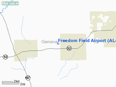
Location
& QuickFacts
|
FAA Information Effective: |
2007-01-18 |
|
Airport
Identifier: |
AL41 |
|
Airport
Status: |
Operational |
|
Longitude/Latitude: |
085-37-31.7600W/31-06-57.6380N
-85.625489/31.116011 (Estimated) |
|
Elevation: |
285 ft / 86.87 m (Estimated) |
|
Land: |
200 acres |
|
From
nearest city: |
1 nautical miles WN of Slocomb, AL |
|
Location: |
Geneva County, AL |
|
Magnetic Variation: |
00W (1985) |
Owner
& Manager
|
Ownership: |
Privately owned |
|
Owner: |
Howard P. Culbreth, Jr. |
|
Address: |
500 W Woodland Ave
Dothan, AL 36301 |
|
Phone
number: |
205-792-1844
WORK PHONE NUMBER 205-886-3541. |
|
Manager: |
Raymond Mc Peak/mac Booth |
|
Address: |
Rt 2, Box 33a
Slocomb, AL 36375 |
|
Phone number: |
205-886-3541 |
Airport
Operations and Facilities
|
Airport Use: |
Private |
|
Wind
indicator: |
Yes |
|
Segmented
Circle: |
No |
|
Control
Tower: |
No |
|
Lighting
Schedule: |
PHONE REQ
FOR MIRL RY 10/28 CALL 205-886-3541. |
|
Beacon
Color: |
Yellow (unlighted seaplane base) |
|
Sectional
chart: |
Jacksonville |
|
Region: |
ASO - Southern |
|
Boundary
ARTCC: |
ZJX - Jacksonville |
|
Tie-in
FSS: |
ANB - Anniston |
|
FSS
Toll Free: |
1-800-WX-BRIEF |
|
Runway Information
Runway 10/28
|
Dimension: |
3300 x 90 ft / 1005.8 x 27.4 m |
|
Surface: |
TURF, |
|
Edge
Lights: |
Medium |
|
|
Runway 10 |
Runway 28 |
|
Traffic
Pattern: |
Left |
Right |
|
Obstruction: |
|
450 ft twr, 2640.0 ft from runway |
|
Radio Navigation
Aids
|
ID |
Type |
Name |
Ch |
Freq |
Var |
Dist |
|
OZ |
NDB |
Ruckr |
|
212.00 |
00E |
11.8 nm |
|
HYE |
NDB |
Hanchey |
|
221.00 |
00E |
15.1 nm |
|
LOR |
NDB |
Lowe |
|
269.00 |
03W |
15.9 nm |
|
BKK |
NDB |
Tri County |
|
275.00 |
02W |
15.9 nm |
|
BVG |
NDB |
Boll Weevil |
|
352.00 |
03E |
22.7 nm |
|
SMY |
NDB |
Soyya |
|
329.00 |
02W |
25.3 nm |
|
XNE |
NDB |
Spring Hill |
|
281.00 |
00E |
38.6 nm |
|
JUY |
NDB |
Judd |
|
264.00 |
02W |
41.0 nm |
|
XBR |
NDB |
Brantley |
|
410.00 |
00E |
43.5 nm |
|
IWJ |
NDB |
Blaak |
|
344.00 |
03W |
46.2 nm |
|
TO |
NDB |
Blood |
|
365.00 |
01W |
49.5 nm |
|
HEY |
VOR |
Hanchey |
|
110.60 |
02E |
15.6 nm |
|
FYL |
VOR |
Tri County |
|
108.40 |
08W |
16.5 nm |
|
EDN |
VOR |
Enterprise |
|
116.60 |
03W |
17.9 nm |
|
UIA |
VOR |
Andalusia |
|
110.20 |
00E |
41.1 nm |
|
OZR |
VOR/DME |
Cairns |
049X |
111.20 |
02E |
10.6 nm |
|
RRS |
VORTAC |
Wiregrass |
053X |
111.60 |
02E |
14.2 nm |
|
MAI |
VORTAC |
Marianna |
087X |
114.00 |
00E |
32.6 nm |
Remarks
Based
Aircraft
|
Aircraft
based on field: |
20 |
|
Single
Engine Airplanes: |
15 |
|
Ultralights: |
5 |
Freedom Field Airport
Address:
Geneva County, AL
Tel:
205-792-1844,
205-886-3541
Images
and information placed above are from
http://www.airport-data.com/airport/AL41/
We
thank them for the data!
| General
Info |
| Country |
United
States |
| State |
ALABAMA
|
| FAA ID |
AL41
|
| Latitude |
31-06-57.638N
|
| Longitude |
085-37-31.760W
|
| Elevation |
285 feet
|
| Near City |
SLOCOMB
|
We don't guarantee the information is fresh and accurate. The data may
be wrong or outdated.
For more up-to-date information please refer to other sources.
|
|


