 |
|
|
|
|
|
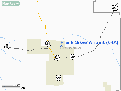
Location
& QuickFacts
|
FAA Information Effective: |
2007-01-18 |
|
Airport
Identifier: |
04A |
|
Airport
Status: |
Operational |
|
Longitude/Latitude: |
086-15-44.8580W/31-44-10.5610N
-86.262461/31.736267 (Estimated) |
|
Elevation: |
300 ft / 91.44 m (Surveyed) |
|
Land: |
35
acres |
|
From
nearest city: |
2 nautical miles N of Luverne, AL |
|
Location: |
Crenshaw County, AL |
|
Magnetic Variation: |
00W (1985) |
Owner
& Manager
|
Ownership: |
Publicly owned |
|
Owner: |
City Of Luverne |
|
Address: |
Po Box 249
Luverne, AL 36049 |
|
Phone number: |
334-335-3741 |
|
Manager: |
Cheryl Yawn |
|
Address: |
Po Box 341
Luverne, AL 36049 |
|
Phone number: |
334-335-6213 |
Airport
Operations and Facilities
|
Airport Use: |
Open to public |
|
Wind
indicator: |
Yes |
|
Segmented
Circle: |
No |
|
Control
Tower: |
No |
|
Lighting
Schedule: |
DUSK-DAWN
ACTVT LIRL RY 04/22 - CTAF. |
|
Beacon
Color: |
Clear-Green (lighted land airport) |
|
Landing
fee charge: |
No |
|
Sectional
chart: |
New Orleans |
|
Region: |
ASO - Southern |
|
Boundary
ARTCC: |
ZTL - Atlanta |
|
Responsible
ARTCC: |
ZJX - Jacksonville |
|
Tie-in
FSS: |
ANB - Anniston |
|
FSS
on Airport: |
No |
|
FSS
Toll Free: |
1-800-WX-BRIEF |
|
NOTAMs
Facility: |
ANB (NOTAM-d service avaliable) |
Airport
Communications
|
CTAF: |
122.800 |
|
Unicom: |
122.800 |
Airport
Services
|
Bottled
Oxygen: |
NONE |
|
Bulk
Oxygen: |
NONE |
|
Runway Information
Runway 04/22
|
Dimension: |
4640 x 80 ft / 1414.3 x 24.4 m |
|
Surface: |
ASPH, Fair Condition |
|
Weight
Limit: |
Single wheel: 15000 lbs. |
|
Edge
Lights: |
Non-standard lighting system
RY 04/22 NSTD LIRL: FIRST 750 FT OF RY 04 & FIRST 875 FT OF
RY 22 UNLGTD. |
|
|
Runway 04 |
Runway 22 |
|
Traffic
Pattern: |
Left |
Left |
|
Markings: |
Basic, Good Condition |
Basic, Good Condition |
|
Displaced
threshold: |
740.00
ft |
875.00
ft |
|
Obstruction: |
44 ft trees, 336.0 ft from runway, 90 ft right
of centerline, 3:1 slope to clear
RY 04 APCH RATIO 24:1 FROM DSPLCD THLD. |
75 ft trees, 1400.0 ft from runway, 16:1 slope
to clear
RY 22 APCH RATIO 30:1 FROM DSPLCD THLD. |
|
Radio Navigation
Aids
|
ID |
Type |
Name |
Ch |
Freq |
Var |
Dist |
|
TO |
NDB |
Blood |
|
365.00 |
01W |
9.8 nm |
|
XBR |
NDB |
Brantley |
|
410.00 |
00E |
10.6 nm |
|
XNE |
NDB |
Spring Hill |
|
281.00 |
00E |
15.1 nm |
|
PRN |
NDB |
Persimmon/dcmsnd |
|
359.00 |
00E |
19.3 nm |
|
JUY |
NDB |
Judd |
|
264.00 |
02W |
26.7 nm |
|
BVG |
NDB |
Boll Weevil |
|
352.00 |
03E |
27.9 nm |
|
LOR |
NDB |
Lowe |
|
269.00 |
03W |
34.9 nm |
|
OZ |
NDB |
Ruckr |
|
212.00 |
00E |
38.3 nm |
|
HYE |
NDB |
Hanchey |
|
221.00 |
00E |
38.4 nm |
|
SE |
NDB |
Pollk |
|
344.00 |
01W |
46.7 nm |
|
MXF |
TACAN |
Maxwell |
097X |
|
03E |
39.0 nm |
|
UIA |
VOR |
Andalusia |
|
110.20 |
00E |
26.5 nm |
|
EDN |
VOR |
Enterprise |
|
116.60 |
03W |
32.2 nm |
|
HEY |
VOR |
Hanchey |
|
110.60 |
02E |
38.1 nm |
|
OZR |
VOR/DME |
Cairns |
049X |
111.20 |
02E |
39.3 nm |
|
MGM |
VORTAC |
Montgomery |
058X |
112.10 |
03E |
29.4 nm |
Remarks
- 480'
MSL WATER TWR SOUTH OF RWY 22.
- VFR
ONLY.
Based
Aircraft
|
Aircraft
based on field: |
4 |
|
Single
Engine Airplanes: |
3 |
|
Multi
Engine Airplanes: |
1 |
Operational Statistics
Time Period: 1999-07-02
- 2000-06-30
|
Aircraft
Operations: |
109/Week |
|
General
Aviation Local: |
5.1% |
|
General
Aviation Itinerant: |
94.9% |
Frank Sikes Airport
Address:
Crenshaw County, AL
Tel:
334-335-3741, 334-335-6213
Images
and information placed above are from
http://www.airport-data.com/airport/04A/
We
thank them for the data!
| General
Info |
| Country |
United
States |
| State |
ALABAMA
|
| FAA ID |
04A
|
| Latitude |
31-44-10.561N
|
| Longitude |
086-15-44.858W
|
| Elevation |
300 feet
|
| Near City |
LUVERNE
|
We don't guarantee the information is fresh and accurate. The data may
be wrong or outdated.
For more up-to-date information please refer to other sources.
|
|


