|
|
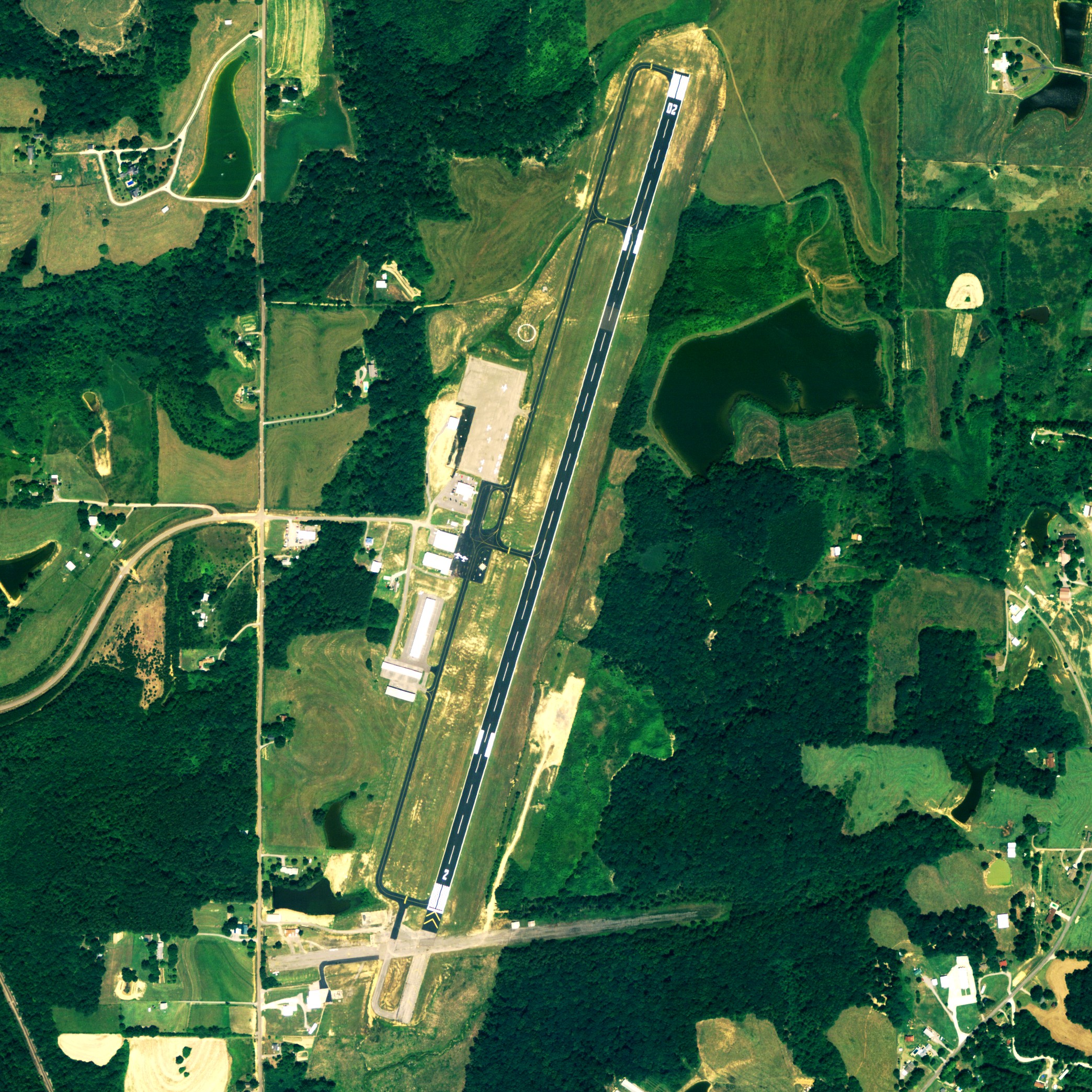
| Folsom Field |
 |
| NAIP aerial image, 24 August 2006 |
| IATA: none â ICAO: none â FAA LID: 3A1 |
| Summary |
| Airport type |
Public |
| Owner |
City & County of Cullman, Alabama |
| Serves |
Cullman, Alabama |
| Elevation AMSL |
969 ft / 295.4 m |
| Coordinates |
34°16â²07â³N 086°51â²29â³W / 34.26861°N 86.85806°W / 34.26861; -86.85806 |
| Runways |
| Direction |
Length |
Surface |
| ft |
m |
| 2/20 |
5,500 |
1,676 |
Asphalt |
| Statistics (2006) |
| Aircraft operations |
37,830 |
| Source: Federal Aviation Administration |
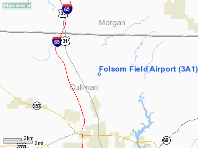
Folsom Field (FAA LID: 3A1) is a city-county owned public-use airport located 5 nautical miles (9 km) north of the central business district of Cullman, a city in Cullman County, Alabama, United States. According to the FAA's National Plan of Integrated Airport Systems for 2009â2013, it is categorized as a general aviation facility. Facilities and aircraft
Folsom Field covers an area of 90 acres (0.14 sq mi; 0.36 km), and contains one runway designated 2/20 that is 5,500 x 100 feet (1,676 x 30 meters) with asphalt pavement. It is located 969 feet, or 295.4 meters above sea level, and for the 12-month period ending July 12, 2006, the airport had 37,830 general aviation/military aircraft operations.
Skydive Alabama
Skydive Alabama, a civilian skydiving center, is operated out of Folsom Field. Skydive Alabama (SA) is a United States Parachute Association (USPA) affiliated drop zone that operates year-round, maintaining a fleet of two jump aircraft, a Beechcraft King Air, and a Cessna 182. Most skydives take place from an altitude of around 14,000 feet. SA maintains USPA certified instructors on staff to provide tandem and Accelerated Freefall (AFF) training for beginning skydivers, as well providing coaching, rigging services, gear sales and rental, and camping areas for experienced skydivers.
The above content comes from Wikipedia and is published under free licenses – click here to read more.
Location
& QuickFacts
|
FAA Information Effective: |
2007-01-18 |
|
Airport
Identifier: |
3A1 |
|
Airport
Status: |
Operational |
|
Longitude/Latitude: |
086-51-28.9350W/34-16-07.3250N
-86.858037/34.268701 (Estimated) |
|
Elevation: |
969 ft / 295.35 m (Surveyed) |
|
Land: |
90
acres |
|
From
nearest city: |
5 nautical miles N of Cullman, AL |
|
Location: |
Cullman County, AL |
|
Magnetic Variation: |
01W (1990) |
Owner
& Manager
|
Ownership: |
Publicly owned |
|
Owner: |
City/county Of Cullman |
|
Address: |
Po Box 278
Cullman, AL 35056 |
|
Phone number: |
256-739-1212 |
|
Manager: |
Bob Burns |
|
Address: |
231 Co Rd 1360
Vinemont, AL 35179 |
|
Phone number: |
256-775-1011 |
Airport
Operations and Facilities
|
Airport Use: |
Open to public |
|
Wind
indicator: |
Yes |
|
Segmented
Circle: |
Yes |
|
Control
Tower: |
No |
|
Lighting
Schedule: |
DUSK-DAWN
ACTVT MIRL RY 02/20 - CTAF. |
|
Beacon
Color: |
Clear-Green (lighted land airport) |
|
Landing
fee charge: |
No |
|
Sectional
chart: |
Atlanta |
|
Region: |
ASO - Southern |
|
Traffic
Pattern Alt: |
1000 ft |
|
Boundary
ARTCC: |
ZME - Memphis |
|
Tie-in
FSS: |
ANB - Anniston |
|
FSS
on Airport: |
No |
|
FSS
Toll Free: |
1-800-WX-BRIEF |
|
NOTAMs
Facility: |
3A1 (NOTAM-d service avaliable) |
|
Federal Agreements: |
NGY |
Airport
Communications
|
CTAF: |
122.800 |
|
Unicom: |
122.800 |
Airport
Services
|
Fuel available: |
100LLA1+ |
|
Airframe Repair: |
MAJOR |
|
Power Plant Repair: |
MAJOR |
|
Bottled
Oxygen: |
NONE |
|
Bulk
Oxygen: |
NONE |
|
Runway Information
Runway 02/20
|
Dimension: |
5500 x 100 ft / 1676.4 x 30.5 m |
|
Surface: |
ASPH, Good Condition |
|
Weight
Limit: |
Single wheel: 30000 lbs. |
|
Edge
Lights: |
Medium |
|
|
Runway 02 |
Runway 20 |
|
Longitude: |
086-51-38.2560W |
086-51-19.6200W |
|
Latitude: |
34-15-41.2450N |
34-16-33.4000N |
|
Elevation: |
935.00
ft |
969.00
ft |
|
Alignment: |
17 |
127 |
|
Traffic
Pattern: |
Left |
Left |
|
Markings: |
Non-precision instrument, Good Condition |
Non-precision instrument, Good Condition |
|
Crossing
Height: |
53.00
ft |
0.00 ft |
|
VASI: |
2-light PAPI on left side |
2-light PAPI on left side |
|
Visual
Glide Angle: |
3.00° |
0.00° |
|
Runway
End Identifier: |
Yes |
Yes |
|
Obstruction: |
126 ft trees, 2397.0 ft from runway, 4 ft left
of centerline, 17:1 slope to clear |
9 ft tree, 249.0 ft from runway, 104 ft left
of centerline, 5:1 slope to clear |
|
Radio Navigation
Aids
|
ID |
Type |
Name |
Ch |
Freq |
Var |
Dist |
|
CPP |
NDB |
Cole Spring |
|
230.00 |
01W |
6.2 nm |
|
HUA |
NDB |
Redstone |
|
287.00 |
00W |
27.2 nm |
|
CWH |
NDB |
Capshaw |
|
350.00 |
01W |
30.6 nm |
|
ARF |
NDB |
Saratoga |
|
296.00 |
02W |
31.5 nm |
|
BH |
NDB |
Mcden |
|
224.00 |
01W |
45.5 nm |
|
DCU |
VOR/DME |
Decatur |
075X |
112.80 |
01W |
23.2 nm |
|
GAD |
VOR/DME |
Gadsden |
070X |
112.30 |
02E |
42.4 nm |
|
RQZ |
VORTAC |
Rocket |
059X |
112.20 |
02E |
33.7 nm |
|
VUZ |
VORTAC |
Vulcan |
091X |
114.40 |
02E |
36.0 nm |
|
MSL |
VORTAC |
Muscle Shoals |
112X |
116.50 |
01E |
41.0 nm |
|
BHM |
VOT |
Birmingham Muni |
|
110.00 |
|
42.7 nm |
|
HSV |
VOT |
Huntsville |
|
111.00 |
|
43.1 nm |
Remarks
- EXTENSIVE
FLIGHT TNG WITHIN ARPT AREA.
- GCO
AVAILABLE ON FREQ 121.725 HUNTSVILLE CLNC.
- BEFORE
FAA ACT.
Based
Aircraft
|
Aircraft
based on field: |
56 |
|
Single
Engine Airplanes: |
40 |
|
Multi
Engine Airplanes: |
6 |
|
Helicopters: |
10 |
Operational Statistics
Time Period: 2005-07-13
- 2006-07-12
|
Aircraft
Operations: |
104/Day |
|
General
Aviation Local: |
40.5% |
|
General
Aviation Itinerant: |
59.2% |
|
Military: |
0.3% |
Folsom Field Airport
Address:
Cullman County, AL
Tel:
256-739-1212, 256-775-1011
Images
and information placed above are from
http://www.airport-data.com/airport/3A1/
We
thank them for the data!
| General
Info |
| Country |
United
States |
| State |
ALABAMA
|
| FAA ID |
3A1
|
| Latitude |
34-16-07.570N
|
| Longitude |
086-51-30.000W
|
| Elevation |
963 feet
|
| Near City |
CULLMAN
|
We don't guarantee the information is fresh and accurate. The data may
be wrong or outdated.
For more up-to-date information please refer to other sources.
|
|